كراي كراسنودار
كراسنودار كراي (روسية: Краснода́рский край, النطق Krasnodarsky kray; النطق الروسي: [krəsnɐˈdarskʲɪj kraj]) هي إحدى الكيانات الفدرالية (كراي)، تقع في منطقة شمال القوقاز في جنوب روسيا، وإدارياً هي جزء من المنطقة الاتحادية الجنوبية. ومركزها الاداري هي مدينة كراسنودار. كثالث أكبر كيان اتحادي من حيث السكان، يبلغ عدد سكان الكراي 5,226,647 حسب تعداد 2010.[10]
Krasnodar Krai | |
|---|---|
| Краснодарский край | |
 Flag  Coat of arms | |
| النشيد: Anthem of Krasnodar Krai[1] | |
 | |
| البلد | روسيا |
| المنطقة الاتحادية | الجنوبية[2] |
| المنطقة الاقتصادية | شمال القوقاز[3] |
| تأسست | September 13, 1937[4] |
| Administrative center | كراسنودار[5] |
| الحكومة | |
| • الكيان | Legislative Assembly[6] |
| • Head of Administration (Governor)[8] | Alexander Tkachyov[7] |
| المساحة | |
| • Total | 76٬000 كم² (29٬000 ميل²) |
| ترتيب المساحة | 42nd |
| التعداد (2010 Census)[10] | |
| • Total | 5٬226٬647 |
| • Estimate (2018) | 5٬603٬420 (+7٫2%) |
| • الترتيب | 3rd |
| • الكثافة | 69/km2 (180/sq mi) |
| • Urban | 52٫9% |
| • الريف | 47٫1% |
| منطقة التوقيت | UTC+3 (توقيت موسكو |
| ISO 3166 code | RU-KDA |
| لوحات السيارات | 23 |
| OKTMO ID | 03000000 |
| اللغات الرسمية | الروسية[12] |
| الموقع الإلكتروني | http://admkrai.krasnodar.ru/ |
كراي كراسنودار كان يُعرف من قبل، وللآن بشكل غير رسمي، بإسم كوبان، وهو تعبير يعود إلى جمهورية كوبان الشعبية السابقة ومنطقة كوبان التاريخية الواقعة بين بحر آزوڤ و نهر كوبان والتي تشمل معظم أراضي الكراي. ويحدها أوبلاست روستوڤ إلى الشمال، كراي ستاڤروپول إلى الشرق، قرة چاي - چركسيا إلى الجنوب الشرقي، و أديگيا هي جيب محاط بالكراي من جميع الجهات. ويتقاسم كراي كراسنودار الحدود الدولية مع جورجيا من الشرق، والحدود المتنازَع عليها مع القرم عبر مضيق كرچ.
. . . . . . . . . . . . . . . . . . . . . . . . . . . . . . . . . . . . . . . . . . . . . . . . . . . . . . . . . . . . . . . . . . . . . . . . . . . . . . . . . . . . . . . . . . . . . . . . . . . . . . . . . . . . . . . . . . . . . . . . . . . . . . . . . . . . . . . . . . . . . . . . . . . . . . . . . . . . . . . . . . . . . . . .
الجغرافيا

*المناطق الأصغر بطول شمال القوقاز هي جمهوريات: قرة چاي - چركسيا، كبردينو - بلقاريا، أوستيا الشمالية - ألانيا، إنگوشتيا، وچچنيا.
*الأصفر هو المنطقة الاتحادية الجنوبية والوردي هو منطقة شمال القوقاز الاتحادية.
Krasnodar Krai is located in the southwestern part of the North Caucasus and borders Rostov Oblast in the northeast, Stavropol Krai and Karachay-Cherkessia in the east, and with the Abkhazia region (internationally recognized as part of Georgia) in the south.[13] The Republic of Adygea is completely encircled by the krai territory. The krai's Taman Peninsula is situated between the Sea of Azov in the north and the Black Sea in the south.[14] In the west, the Kerch Strait separates the krai from the contested Crimean Peninsula, internationally recognised as part of Ukraine but under de facto Russian control.[14] At its widest extent, the krai stretches for 327 kilometers (203 mi) from north to south and for 360 kilometers (220 mi) from east to west.[13]
The krai is split into two distinct parts by the Kuban River, which gave its name to this entire geographic region.[14] The southern, seaward part is the western extremity of the Caucasus range, lying within the Crimean Submediterranean forest complex ecoregion;[15] the climate is Mediterranean or, in the southeast, subtropical.[14] Historically it is known as Circassia. The northern part is a steppe zone which shares continental climate patterns.[14] It is also known as Kuban region.
The height of the mountains exceeds 3,000 meters (9,800 ft), with Mount Tsakhvoa being the highest at 3,346 meters (10,978 ft),[14]with Mount Fisht, at 2,867 meters (9,406 ft), being the Great Caucasus' westernmost peak with a glacier.[14]
The Black Sea coast stretches from the Kerch Strait to Adler and is shielded by the Caucasus Mountains from the cold northern winds.[14] Numerous small mountain rivers flow in the coastal areas, often creating picturesque waterfalls.[14]
Lake Abrau, located in the wine-making region of Abrau-Dyurso, is the largest lake in the northeastern Caucasus region.[14]
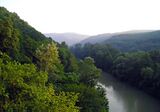 A hilly landscape near Goryachy Klyuch
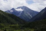 Mount Tsakhvoa is the highest peak in Krasnodar Krai
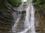 Pshadskiye Waterfalls
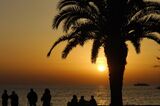 On a beach in Sochi


التاريخ
The region's earliest known inhabitants are referred to, generally, as the Maiōtai, who are the ancestors of the modern-day Circassians, Abkhazians and Abazins[16] (after the Greek name for the Sea of Azov). During the 6th century BC, Pontic Greeks founded the area's first cities, such as Phanagoria (near modern Sennoy) and Hermonassa (on the Taman Peninsula), who traded with nomadic tribes including the Skuthai (Scythians) and Sindi.
From the 8th to the 10th centuries, the area was dominated by the Khazars, a Turkic people who had earlier migrated from the east onto the Pontic-Caspian Steppe, where a hypothesis claims that they converted to Judaism. After the defeat of the Khazar Khanate in 965 Kievan Prince Svyatoslav conquered the area, it came under the rule of Kievan Rus', and it then formed the Tmutarakan principality. Later, due to the increasing claims of the Eastern Roman Empire at the end of the 11th century, the Tmutarakan principality came under the authority of the Eastern Roman Emperors (until 1204).[بحاجة لمصدر]
In that period of history, the Circassians were first mentioned, under the ethnonym Kassogs. For example, the Kassog Prince Rededya was mentioned in The Tale of Igor's Campaign.[17]
In 1243–1438, the current territory of the Kuban was part of the Golden Horde. After the latter's collapse, parts of Kuban were held under the Crimean Khanate, Circassia, and the Ottoman Empire, which dominated the region. The Tsardom of Russia began to challenge the protectorate of the Ottoman Empire in the area during the Russo-Turkish wars.

In April 1783, after the liquidation of the Crimean Khanate, right-bank Kuban and Taman Peninsula were annexed to the Russian Empire by decree of Catherine II. In 1792–1794, the Cossacks moved there from Zaporizhzhia, now located in Ukraine, and formed the Black Sea Area troops, with the creation of a solid cordon line for the Kuban River and the marginalization of the neighboring Circassians. The administrative region was accorded the status of "Land of Black Sea Cossack Army", with its center in the city of Yekaterinodar (renamed Krasnodar by the Bolsheviks in 1920).
In 1900, the region's population numbered around two million people. In 1913, the gross grain harvest Kuban region entered second place in Russia, for the production of marketable grain – in first place.[مطلوب توضيح] During the Russian Civil War, the anti-communist Kuban People's Republic was established on 28 January 1918. It sought union with the Ukrainian People's Republic during its brief independence until Soviet forces occupied the latter in May 1920.
Krasnodar Krai was founded on 13 September 1937, when Azov-Black Sea Krai of the Russian SFSR was split up in Krasnodar Krai and Rostov Oblast. On 30 January 1996 Krasnodar Krai signed a power-sharing agreement with the federal government, granting it autonomy.[18] This agreement would be abolished on 12 April 2002.[19]
فيضانات 2012
On July 7, 2012, at least 171 people died in Krasnodar Krai, after torrential rains overnight caused the worst flooding and landslides in more than seventy years.[20][21] Over 280 millimeters (11 in) of rain – the typical amount for a four- or five-month period – was reported to have fallen within forty-eight hours.[22] A local police spokesman stated that most of the dead were in Krymsky District, where at least 159 died when a wave of water 5 meters (16 ft) high swept through the town of Krymsk in the middle of the night.[21][22] Ten more deaths occurred in Gelendzhik, including five electrocuted when a transformer fell into the floodwater, and two in Novorossiysk.[20][22] Authorities stated that 17 people had been officially reported missing, and there were fears the death toll would rise further, while medics had hospitalized 210 people, including 16 children.[بحاجة لمصدر]
The regional government claimed that over 24,000 people were affected by the floods, with more than 3,000 evacuated, and that more than 10,000 rescuers and 140 helicopters were searching for victims and evacuating survivors.[20][22] In Krymsk, 14 temporary shelters were set up to house around 2,000 evacuees.[بحاجة لمصدر] The transport system in the region was said to have collapsed, while oil shipments from Novorossiysk were halted when the port, located in the lower part of the city, was threatened by landslides.[20][22][23] Russia's President Vladimir Putin flew to the area to hold emergency talks with officials in Krymsk, while authorities in Perm Krai dispatched a rescue team to evacuate dozens of children from the region, who had been staying at summer camps on the Black Sea coast.[20][23]
Residents of Krymsk claimed the wave of water that hit the town resulted from the sluice gates of a nearby reservoir being opened, although the prosecutor general's investigative committee denied this. Local prosecutors had earlier confirmed that the gates were opened, but stated that it was too early to determine whether this was the cause of the flooding.[21]
الاقتصاد
النقل


الديمغرافيا
الجماعات العرقية: the 2010 Census identified ethnic groups, as shown in the following table:[10]
| التعداد | العرقية | النسبة من إجمالي السكان |
|---|---|---|
| 4,522,962 | روس | 88.3% |
| 281,680 | أرمن | 5.5% |
| 83,746 | أوكران | 1.6% |
| 24,840 | تتار | 0.5% |
| 22,595 | يونان | 0.4% |
| 17,826 | گرج | 0.3% |
| 16,890 | بلاروس | 0.3% |
| 13,834 | أديغه | 0.3% |
| 12,920 | غجر | 0.3% |
| 12,171 | ألمان | 0.2% |
| 10,165 | آذريون | 0.2% |
| 8,527 | أتراك | 0.2% |
| 5,170 | Moldovans | 0.1% |
| 3,764 | Assyrians | 0.1% |
| 79,768 | Others | 1.5% |
- 101,657 people were registered from administrative databases, and could not declare an ethnicity. It is estimated that the proportion of ethnicities in this group is the same as that of the declared group.[24]
الإحصائيات الحيوية لعام 2007: Source
- Birth Rate: 11.19 per 1000
- Death Rate: 14.39 per 1000
- Net Immigration: +7.1 per 1000
- NGR: -0.32% per Year
- PGR: +0.39% per Year
الإحصائيات الحيوية لعام 2008:[25]
- Population (Jan 2009): 5,100,000
- Births (2008): 62,200
- Deaths (2008): 72,900
- الإحصائيات الحيوية لعام 2012
- Births: 69 031 (13.1 per 1000)
- Deaths: 69 427 (13.1 per 1000) [26]
- Total fertility rate:[27]
2009 - 1.59 | 2010 - 1.57 | 2011 - 1.58 | 2012 - 1.70 | 2013 - 1.72(e)
الدين
According to a 2012 official survey[28] 52.2% of the population of Krasnodar Krai adheres to the Russian Orthodox Church, 3% are unaffiliated generic Christians, 1% adheres to other Orthodox Churches, and 1% are Muslims. In addition, 22% of the population deems itself to be "spiritual but not religious", 13% is atheist, and 7.8% follows other religions or did not give an answer to the question.[28]
. . . . . . . . . . . . . . . . . . . . . . . . . . . . . . . . . . . . . . . . . . . . . . . . . . . . . . . . . . . . . . . . . . . . . . . . . . . . . . . . . . . . . . . . . . . . . . . . . . . . . . . . . . . . . . . . . . . . . . . . . . . . . . . . . . . . . . . . . . . . . . . . . . . . . . . . . . . . . . . . . . . . . . . .
التقسيم الاداري
وتحوي المدن والقرى التالية:
أبينسك،
أنابا،
أبشيرونسك،
- أرمافير،
- بيلوريتشينسك،
- گيلينجيك،
- گورياتشي كليوتش،
- گولكيفيتشي،
- خاديجينسك،
- كورنوفسك،
- كراسنودار،
- كروبوتكين،
- كريمسك،
- كورگاننسك،
سلافايانسك-نا-كوباني، سوتشي، تمرايوك، تيخورتسك، تيماشايوفسك، توابسي، أوست-لابينسك، ييسك،
المراجع
الهامش
- ^ Law #5-KZ
- ^ Президент Российской Федерации. Указ №849 от 13 мая 2000 г. «О полномочном представителе Президента Российской Федерации в федеральном округе». (President of the Russian Federation. Decree #849 of May 13, 2000 On the Plenipotentiary Representative of the President of the Russian Federation in a Federal District).
- ^ Госстандарт Российской Федерации. №ОК 024-95 27 декабря 1995 г. «Общероссийский классификатор экономических регионов. 2. Экономические районы», в ред. Изменения №5/2001 ОКЭР. (گوستاندارت of the Russian Federation. #OK 024-95 December 27, 1995 Russian Classification of Economic Regions. 2. Economic Regions, as amended by the Amendment #5/2001 OKER).
- ^ Azarenkova et al., p. 114
- ^ Charter of Krasnodar Krai, Article 13
- ^ Charter of Krasnodar Krai, Chapter 24
- ^ Official website of Krasnodar Krai. Biography of Alexander Nikolayevich Tkachyov, Governor of Krasnodar Krai (بالروسية)
- ^ Charter of Krasnodar Krai, Article 39
- ^ Федеральная служба государственной статистики (Federal State Statistics Service) (2004-05-21). "Территория, число районов, населённых пунктов и сельских администраций по субъектам Российской Федерации (Territory, Number of Districts, Inhabited Localities, and Rural Administration by Federal Subjects of the Russian Federation)". Всероссийская перепись населения 2002 года (All-Russia Population Census of 2002) (in الروسية). Federal State Statistics Service. Retrieved 2011-11-01.
- ^ أ ب ت Russian Federal State Statistics Service (2011). "Всероссийская перепись населения 2010 года. Том 1". Всероссийская перепись населения 2010 года (2010 All-Russia Population Census) (in Russian). Federal State Statistics Service. Retrieved June 29, 2012.
{{cite web}}: Invalid|ref=harv(help); Unknown parameter|trans_title=ignored (|trans-title=suggested) (help)CS1 maint: unrecognized language (link) - ^ "Об исчислении времени". Официальный интернет-портал правовой информации (in الروسية). 3 June 2011. Retrieved 19 January 2019.
- ^ الرسمية في جميع أرجاء روسيا الاتحادية حسب الفقرة 68.1 من دستور روسيا.
- ^ أ ب Official website of Krasnodar Krai. General Information About the Region Archived أكتوبر 11, 2017 at the Wayback Machine (in روسية)
- ^ أ ب ت ث ج ح خ د ذ ر Gorshenyov
- ^ WWF. Central Asia: Southwest Russia and the Crimean Peninsula on the Black Sea coast
- ^ "Адыги - Энциклопедия, Большая Советская". gatchina3000.ru. Retrieved 2023-03-11.
- ^ "The Song of Igor's Campaign, Igor son of Svyatoslav and grandson of Oleg". lib.ru. Retrieved 2023-03-11.
- ^ Solnick, Steven (29 May 1996). "Asymmetries in Russian Federation Bargaining" (PDF). The National Council for Soviet and East European Research: 12.
- ^ Chuman, Mizuki. "The Rise and Fall of Power-Sharing Treaties Between Center and Regions in Post-Soviet Russia" (PDF). Demokratizatsiya: 146.
- ^ أ ب ت ث ج "Russia Flash Floods: 144 Killed in Krasnodar Region". BBC News. London. July 7, 2012. Retrieved 7 July 2012.
- ^ أ ب ت Elder, Miriam (July 9, 2012). "Russian Floods Kill 150 and Leave Thousands Homeless". The Guardian. London. Retrieved July 9, 2012.
- ^ أ ب ت ث ج "Over 100 Die in Russia as Floods and Landslides Hit Krasnodar Region". The Guardian. London. July 7, 2012. Retrieved July 7, 2012.
- ^ أ ب "Vladimir Putin Flies to Flood-hit Southern Russia as Death Toll Rises". The Guardian. London. July 8, 2012. Archived from the original on July 10, 2012. Retrieved July 9, 2012.
- ^ Перепись-2010: русских становится больше. Perepis-2010.ru (2011-12-19). Retrieved on 2012-07-07.
- ^ Население Краснодарского края в 2008 году увеличилось на 0,4% - Новости России - ИА REGNUM. Regnum.ru (2009-02-19). Retrieved on 2012-07-07.
- ^ http://www.gks.ru/free_doc/2012/demo/edn12-12.htm
- ^ http://www.gks.ru/wps/wcm/connect/rosstat_main/rosstat/ru/statistics/publications/catalog/doc_1137674209312
- ^ أ ب ت Arena - Atlas of Religions and Nationalities in Russia. Sreda.org
- ^ 2012 Survey Maps. "Ogonek", № 34 (5243), 27/08/2012. Retrieved 24-09-2012.
المصادر
- Законодательное Собрание Краснодарского края. Закон №5-КЗ от 5 мая 1995 г. «О символах Краснодарского края», в ред. Закона №2957-КЗ от 8 мая 2014 г. «О внесении изменений в Закон Краснодарского края "О символах Краснодарского края"». (Legislative Assembly of Krasnodar Krai. Law #5-KZ of May 5, 1995 On the Symbols of Krasnodar Krai, as amended by the Law #2957-KZ of May 8, 2014 On Amending the Law of Krasnodar Krai "On the Symbols of Krasnodar Krai").
- قالب:RussiaBasicLawRef/kda
- Горшенёв, М. А. (1983). Путешествия по Краснодарскому краю (in Russian). Физкультура и спорт.
{{cite book}}: CS1 maint: unrecognized language (link) - Азаренкова, А. С.; И. Ю. Бондарь; Н. С. Вертышева (1986) [1986]. Основные административно-территориальные преобразования на Кубани (1793–1985 гг.) (in Russian). Краснодарское книжное издательство.
{{cite book}}: CS1 maint: unrecognized language (link)