بريطانيا العظمى
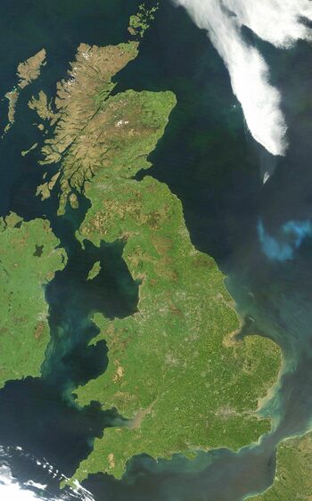
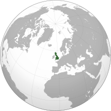
بريطانيا العظمى Great Britain (ويلزية: Prydain Fawr، غالية اسكتلندية: Breatainn Mhòr، الكورنية: Breten Veur، سكوتس: Great Breetain)، وتعرف أيضاً باسم بريطانيا، هي جزيرة تقع في شمال-غرب القارة الاوروپية. وهي تاسع أكبر جزيرة في العالم، وأكبر الجزر الاوروپية وأكبر الجزر البريطانية. في منتصف 2010 كان عدد سكانها 62 مليون نسمة، لتصبح ثالث أكبر جزيرة مأهولة في العالم، بعد جاوة وهونشو.يحيط بها أكثر من 1.000 جزيرة وجزيرة صغرى. تقع جزيرة أيرلندا إلى الغرب منها. سياسياً، يشير اسم بريطانيا العظمى إلى الجزيرة نفسها وعدد من الجزر المحيطة بها، والتي تكون أراضي إنگلترة، إسكتلندا وويلز.[9][10][11][12][13][14]
Other native names
| |
|---|---|
 | |
 | |
| الجغرافيا | |
| الموقع | North-western Europe |
| الإحداثيات | 54°N 2°W / 54°N 2°WCoordinates: 54°N 2°W / 54°N 2°W |
| الأرخبيل | British Isles |
| قريبة من | Atlantic Ocean |
| المساحة | 209,331 km2 (80,823 sq mi)[1] |
| ترتيب المساحة | 9th |
| أعلى منسوب | 1٬345 m (4٬413 ft) |
| أعلى نقطة | Ben Nevis[2] |
| الإدارة | |
| Countries | |
| Largest city | London (pop. 8,878,892) |
| السكان | |
| التعداد | 60,800,000 (2011 census)[3] |
| ترتيب التعداد | 3rd |
| الكثافة السكانية | 302 /km2 (782 /sq mi) |
| اللغات | |
| الجماعات العرقية | |
| معلومات إضافية | |
| Time zone | |
| • Summer (DST) | |
الجزيرة بالكامل هي أراضي دولة المملكة المتحدة لبريطانيا العظمى وأيرلندا الشمالية السيادية، وتشكل بريطانيا العظمى معظم أراضي المملكة المتحدة. معظم إنگلترة وإسكتلندا وويلز على جزيرة بريطانيا العظمى، وعواصهم بالترتيب هي: لندن، إدنبرة، وكارديف.
تكونت مملكة بريطانيا العظمى من الاتحاد السياسي لممالك إنگلترة وإسكتلندا حسب قوانين الاتحاد 1707 الصادرة في 1 مايو 1707 في عهد الملكة آن. عام 1801، تحت قانون الاتحاد، اندمجت المملكة مع مملكة أيرلندا فتأسست المملكة المتحدة لبريطانيا العظمى وأيرلندا. بعد حرب الاستقلال الأيرلندية (1919-1921) انضمت معظم أيرلندا للاتحاد، لتتأسس المملكة المتحدة لبريطانيا العظمى وأيرلندا الشمالية.
تنوع الحياة الحيوانية والنباتية في بريطانيا العظمى محدود مقارنة بالقارة الأوروپية نظراً لحجم الجزيرة حقيقة أن الحياة البرية كان متاحاً لها زمن محدود للتطور منذ العصر الجليدي الأخير. بالنسبة للفطريات فالمعلومات المتوافرة غير وافية لعقد مقارنات مفيدة. ساهم ارتفاع مستوى التحضر على الجزيرة في زيادة معدل انقراض الأنواع إلى حوالي 100 مرة أكثر من من معدل الانقراض الطبيعي.[بحاجة لمصدر]
. . . . . . . . . . . . . . . . . . . . . . . . . . . . . . . . . . . . . . . . . . . . . . . . . . . . . . . . . . . . . . . . . . . . . . . . . . . . . . . . . . . . . . . . . . . . . . . . . . . . . . . . . . . . . . . . . . . . . . . . . . . . . . . . . . . . . . . . . . . . . . . . . . . . . . . . . . . . . . . . . . . . . . . .
التعريف السياسي
التعريف الجغرافيا
التاريخ
- مقالات مفصلة: تاريخ ويلز
- تاريخ المملكة المتحدة
- مقالات مفصلة: بريطانيا العصور الوسطى
- بريطانيا أوائل العصر الحديث
اللغات
التسمية
- مقالة مفصلة: تسمية الجزر البريطانية
اشتقاق مصطلح "العظمى"
استخدام مصطلح بريطانيا العظمى
التنوع الحيوي
الحيوانات
الفطريات
النباتات
الديانات
المدن
. . . . . . . . . . . . . . . . . . . . . . . . . . . . . . . . . . . . . . . . . . . . . . . . . . . . . . . . . . . . . . . . . . . . . . . . . . . . . . . . . . . . . . . . . . . . . . . . . . . . . . . . . . . . . . . . . . . . . . . . . . . . . . . . . . . . . . . . . . . . . . . . . . . . . . . . . . . . . . . . . . . . . . . .
المدن العواصم
عواصم بلدان المملكة المتحدة الثلاثية المؤسسة لبريطانيا العظمى هي:
مدن كبرى أخرى
أكبر المدن حسب عدد سكان المنطقة الكبرى، ولا تشمل المدن العواصم، هي برمنگهام، برايتون وهوڤ، بريستول، كوڤنتري، گلاسگو، ليدز، ليڤرپول، مانشستر، نيوكاسل أپون تيان، نوتينگهام وشيفلد.
انظر أيضاً
المصادر
الهوامش
- ^ ISLAND DIRECTORY, United Nations Environment Programme. Retrieved 9 August 2015.
- ^ "Great Britain's tallest mountain is taller". Ordnance Survey Blog. 18 March 2016.
- ^ 2011 Census: Population Estimates for the United Kingdom. In the 2011 census, the population of England, Wales and Scotland was estimated to be approximately 61,370,000; comprising 60,800,000 on Great Britain, and 570,000 on other islands. Retrieved 23 January 2014
- ^ "Ethnic Group by Age in England and Wales". www.nomisweb.co.uk. Retrieved 2 February 2014.
- ^ "Ethnic groups, Scotland, 2001 and 2011" (PDF). www.scotlandscensus.gov.uk. Retrieved 2 February 2014.
- ^ Britain, Oxford English Dictionary, http://oxforddictionaries.com/definition/Britain, "Britain:/ˈbrɪt(ə)n/ the island containing England, Wales, and Scotland. The name is broadly synonymous with Great Britain, but the longer form is more usual for the political unit."
- ^ Great Britain, Oxford English Dictionary, http://oxforddictionaries.com/definition/Great+Britain, "Great Britain: England, Wales, and Scotland considered as a unit. The name is also often used loosely to refer to the United Kingdom."
- ^ Peters, Pam (2004). The Cambridge Guide to English Usage. Cambridge, England: Cambridge University Press. p. 79. ISBN 0-521-62181-X.
The term Britain is familiar shorthand for Great Britain
- ^ Definitions and recommended usage varies. For example, the Oxford English Dictionary defines Britain as an island and Great Britain as a political unit formed by England, Scotland and Wales.[6][7] حيث يطلق دليل كمبردج للاستخدام الإنگليزي اسم بريطانيا "كاختصار شائع لجزيرة بريطانيا العظمى، التي تحتوي جغرافياً على ويلز وإسكتلندا".[8]
- ^ خطأ استشهاد: وسم
<ref>غير صحيح؛ لا نص تم توفيره للمراجع المسماةnote0 - ^ "Islands by land area, United Nations Environment Programme". Islands.unep.ch. Retrieved 2012-02-24.
- ^ "Population Estimates" (PDF). National Statistics Online. Newport, Wales: Office for National Statistics. 24 June 2010. Retrieved 24 September 2010.[dead link]
- ^ See Geohive.com Country data; Japan Census of 2000; United Kingdom Census of 2001. The editors of List of islands by population appear to have used similar data from the relevant statistics bureaux, and totalled up the various administrative districts that make up each island, and then done the same for less populous islands. An editor of this article has not repeated that work. Therefore this plausible and eminently reasonable ranking is posted as unsourced common knowledge.
- ^ "says 803 islands which have a distinguishable coastline on an Ordnance Survey map, and several thousand more exist which are too small to be shown as anything but a dot". Mapzone.ordnancesurvey.co.uk. Retrieved 2012-02-24.
- ^ "The Robin – Britain's Favourite Bird". BritishBirdLovers.co.uk. Retrieved 2011-08-15.
- ^ Neasden temple, the largest Hindu temple outside of India[dead link]
المراجع
- Pliny the Elder (translated by Rackham, Harris) (1938). Natural History. Harvard University Press.
- Ball, Martin John (1994). The Celtic Languages. Routledge. ISBN 0-415-01035-7.
- Butler, Alban (1997). Butler's Lives of the Saints. Continuum International Publishing Group. ISBN 0-86012-255-7.
- Frodin, D. G. (2001). Guide to Standard Floras of the World. Cambridge University Press. ISBN 0-521-79077-8.
- Spencer, Colin (2003). British Food: An Extraordinary Thousand Years of History. Columbia University Press. ISBN 0-231-13110-0.
- Andrews, Robert (2004). The Rough Guide to Britain. Rough Guides Ltd. ISBN 1-84353-301-4.
- Dawkins, Peter (2004). The Shakespeare Enigma. Polair Publishing. ISBN 0-9545389-4-3.
- Major, John (2004). History in Quotations. Cassell. ISBN 0-304-35387-6.
- Else, David (2005). Great Britain. Lonely Planet. ISBN 1-74059-921-7.
- Kaufman, Will; Slettedahl, Heidi Macpherson (2005). Britain and the Americas: Culture, Politics, and History. ABC-Clio. ISBN 1-85109-431-8.
- Oppenheimer, Stephen (2006). Origins of the British. Carroll & Graf. ISBN 0-7867-1890-0.
- Room, Adrian (2006). Placenames of the World. McFarland. ISBN 0-7864-2248-3.
- Massey, Gerald (2007). A Book of the Beginnings, Vol. 1. Cosimo. ISBN 1-60206-829-1.
- Taylor, Isaac (2008). Names and Their Histories: A Handbook of Historical Geography and Topographical Nomenclature. BiblioBazaar. ISBN 0-559-29667-3.
- Legon, N.W.; Henrici, A. (2005). Checklist of the British & Irish Basidiomycota. Royal Botanic Gardens, Kew. ISBN 1-84246-121-4.
- Cannon, P.F.; Hawksworth, D.L.; M.A., Sherwood-Pike (1985). The British Ascomycotina. An Annotated Checklist. Commonwealth Mycological Institute & British Mycological Society. ISBN 0-85198-546-7.
. . . . . . . . . . . . . . . . . . . . . . . . . . . . . . . . . . . . . . . . . . . . . . . . . . . . . . . . . . . . . . . . . . . . . . . . . . . . . . . . . . . . . . . . . . . . . . . . . . . . . . . . . . . . . . . . . . . . . . . . . . . . . . . . . . . . . . . . . . . . . . . . . . . . . . . . . . . . . . . . . . . . . . . .
وصلات خارجية
- خريطة تفاعلية لبريطانيا العظمى
- Coast – استكشافات بي بي سي على سواحل بريطانيا العظمى
- الجزر البريطانية
- 200 مدينة وبلدة كبرى في الجزر البريطانية
- كتاب الحقائق - الجزر البريطانية