محافظة أغري
محافظة أغري (كردي: Parêzgeha Agirî/پارێزگای ئاگری, تركية: Ağrı ili؛ إنگليزية: Ağrı Province)، هي إحدى محافظات تركيا، تحدها إيران من الشرق، قارص من الشمال، أرضروم من الشمال الغربي، موش وبيطليس من الجنوب الغربي، ڤان من الشمال الشرقي. مساحتها 11.37 كم². عدد سكنها 542,022 (تعداد 2010). عاصمتها أغري، وتقع على ارتفاع 1.650 متر.
محافظة أغري
Ağrı ili | |
|---|---|
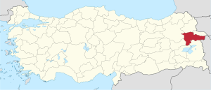
 موقع محافظة أغري في تركيا. | |
| البلد | تركيا |
| المنطقة | شمال شرق الأناضول |
| المنطقة الفرعية | أغري |
| الحكومة | |
| • الدائرة الانتخابية | أغري |
| • المحافظ | عثمان ڤارول |
| المساحة | |
| • الإجمالي | 11٫376 كم² (4٫392 ميل²) |
| التعداد (2020)[1] | |
| • الإجمالي | 535٫435 |
| • الكثافة | 47/km2 (120/sq mi) |
| مفتاح الهاتف | 0472 |
| لوحة السيارة | 04 |
| الموقع الإلكتروني | http://www.agri.gov.tr |
. . . . . . . . . . . . . . . . . . . . . . . . . . . . . . . . . . . . . . . . . . . . . . . . . . . . . . . . . . . . . . . . . . . . . . . . . . . . . . . . . . . . . . . . . . . . . . . . . . . . . . . . . . . . . . . . . . . . . . . . . . . . . . . . . . . . . . . . . . . . . . . . . . . . . . . . . . . . . . . . . . . . . . . .
المقاطعات
تنقسم محافظة أغري إلى 8 مقاطعات (المقاطعة العاصمة بالخط العريض):
الجغرافيا
Ağrı is named after the nearby Mount Ararat, a 5,137 metres (16,854 ft) high stratovolcano, the highest mountain in Turkey and a national symbol to Armenians (see Western Armenia). It can be climbed from here and can be seen from parts of Azerbaijan, Iran, Georgia, and Armenia. The nearest town to the mountain is Doğubayazıt.
46% of the province is mountainous, 29% is plain, 18% is plateau, and 7% high meadow. As well as Ararat there are many other peaks over 3,000m, including Aladağlar and Tendürek. The plains are fertile, being covered in volcanic deposits, and are used for growing grains and grazing. Various tributaries of the Murat River (which later feeds the Euphrates) flow through the area and water these plains. The high meadows are used for grazing.
The weather here is very cold (temperatures as low as -10°C (14°F) in winter) and the mountainsides are mainly bare. There are a number of important passes and routes through the mountains.
التاريخ
The plateau of Ağrı was controlled by the Kingdom of Urartu until its transition to the Kingdom of Armenia. The area was coveted by many as a gateway between east and west. It was conquered numerous times by Assyrians, Greeks, Romans, Byzantines, Arabs, Georgians, Mongols, Persians, and finally by the Seljuq and Ottoman Turks.
The first Muslims in the area were the Abbasids in 872. The Turkish tribes began to pass through in huge numbers following the defeat of the Byzantine armies at Malazgirt in 1071, sometimes pursued by Mongols. The land was brought into the Ottoman Empire by Sultan Selim I following the Battle of Chaldiran. The region was part of the Erzurum Vilayet during the Ottoman Empire.
أحداث معاصرة
في 19 أغسطس 2006، تم تفجير خط أنابيب تبريز-أنقرة للغاز الطبيعي المار في المحافظة. تشتبه السلطات التركية بمسئولية انفصاليو حزب العمال الكردستاني عن الحادث .[2]
الديموغرافيا
| المقاطعة | Total | Urban | Rural |
|---|---|---|---|
| Ağrı | 150,263 | 310,896 | 224,539 |
| Patnos | 123,203 | 63,786 | 59,417 |
| Doğubayazıt | 120,320 | 80,607 | 39,334 |
| Diyadin | 41,789 | 20,387 | 20,889 |
| Eleşkirt | 32,316 | 9,969 | 22,347 |
| Tutak | 29,987 | 7,018 | 22,969 |
| Taşlıçay | 20,028 | 6,180 | 13,848 |
| Hamur | 17,908 | 3,293 | 14,615 |
| Province | 535,435 | 310,896 | 224,539 |
المصادر
- ^ خطأ استشهاد: وسم
<ref>غير صحيح؛ لا نص تم توفيره للمراجع المسماةTUIK2020 - ^ "Gas pipeline explodes in Turkish rebel region". CNN. 2006-08-19. Archived from the original on 2006-08-24. Retrieved 2008-04-04.
وصلات خارجية
- حكومة المحافظة
- (إنگليزية) Ağrı Weather Forecast Information