السند
السند (بالسندي: سنڌ, بالسنسكريتية: सिंध) هي أحد أقاليم پاكستان علي أطراف نهر السند وهي موطن السنديون. ويوجد في السند ثقافات وجماعات عرقية متعددة منها اللاجئون المسلمون المتحدثون بالأردو، والذين هاجرو من الهند إلى پاكستان عند الإستقلال بالإضافة إلى جامعات أخرى هاجرت إليها من إقاليم أخرى بعد الإستقلال. ويجاور السند بلوچستان من الغرب والشمال، پنجاب من الشمال، گوجرات وراجستان من الجنوب الشرقي والشرق، وبحر العرب من الجنوب. اللغة الرئيسية هي السندي.
Sindh
| |
|---|---|
عكس عقارب الساعة من أعلى اليسار:
مزار قائد، كراتشي، فيض محل - خيرپور، حي الأعمال في كراتشي، موهنجو دارو، جسر لاندزداون - سكور، جسر كتري على نهر السند. | |
 Flag | |
 موقع السند في پاكستان | |
| الإحداثيات: 24°52′N 67°03′E / 24.87°N 67.05°ECoordinates: 24°52′N 67°03′E / 24.87°N 67.05°E | |
| البلد | |
| تأسست | 1 يوليو 1970 |
| العاصمة | كراتشي |
| أكبر مدينة | كراتشي |
| الحكومة | |
| • النوع | مقاطعة |
| • الكيان | مجلس إقليمي |
| • الحاكم | د. عشرة العباد خان |
| • كبير الوزراء | سيد قائم علي شاه |
| المساحة | |
| • الإجمالي | 140٬914 كم² (54٬407 ميل²) |
| التعداد (2009 est.)[1] | |
| • الإجمالي | 35٬470٬648 |
| • الكثافة | 250/km2 (650/sq mi) |
| منطقة التوقيت | UTC+5 (PKT) |
| اللغة الرئيسية |
|
| Assembly seats | 168[5] |
| الضلوع | 23 |
| بلدات | 119 |
| مجالس وحدات | 1108[6] |
| الموقع الإلكتروني | sindh.gov.pk |


.jpg&filetimestamp=20230428034524&)


The economy of Sindh is the second-largest in Pakistan after the province of Punjab; its provincial capital of Karachi is the most populous city in the country as well as its main financial hub. Sindh is home to a large portion of Pakistan's industrial sector and contains two of the country's busiest commercial seaports: Port Qasim and the Port of Karachi. The remainder of Sindh consists of an agriculture-based economy and produces fruits, consumer items and vegetables for other parts of the country.[7][8][9]
Sindh is sometimes referred to as the Bab-ul Islam (تر. 'Gateway of Islam'), as it was one of the first regions of the Indian subcontinent to fall under Islamic rule. Parts of the modern-day province were intermittently subject to raids by the Rashidun army during the early Muslim conquests, but the region did not fall under Muslim rule until the Arab invasion of Sind occurred under the Umayyad Caliphate, headed by Muhammad ibn Qasim in 712 CE.[10][11] Ethnic Sindhi people constitute the largest group in the province; Sindh is also the place of residence for the overwhelming majority of Muhajirs (حرفياً 'migrants'), a multiethnic group of Indian Muslims who migrated to the region after the Partition of British India in 1947. The province is well known for its distinct culture, which is strongly influenced by Sufism, an important marker of Sindhi identity for both Hindus and Muslims.[12] Several important Sindhi Sufi shrines are located throughout the province and attract millions of devotees annually.
Sindh is prominent for its history during the Bronze Age under the Indus Valley civilization, and is home to two UNESCO-designated World Heritage Sites: the Makli Necropolis and Mohenjo-daro.[13]
. . . . . . . . . . . . . . . . . . . . . . . . . . . . . . . . . . . . . . . . . . . . . . . . . . . . . . . . . . . . . . . . . . . . . . . . . . . . . . . . . . . . . . . . . . . . . . . . . . . . . . . . . . . . . . . . . . . . . . . . . . . . . . . . . . . . . . . . . . . . . . . . . . . . . . . . . . . . . . . . . . . . . . . .
أصل الاسم
The Greeks who conquered Sindh in 325 BCE under the command of Alexander the Great referred to the Indus River as Indós, hence the modern Indus. The ancient Iranians referred to everything east of the river Indus as hind.[14][15] The word Sindh is a Persian derivative of the Sanskrit term Sindhu, meaning "river" - a reference to Indus River.[16]
Southworth suggests that the name Sindhu is in turn derived from Cintu, a Dravidian word for date palm, a tree commonly found in Sindh.[17][18]
The previous spelling "Sind" (from the Perso-Arabic سند) was discontinued in 1988 by an amendment passed in Sindh Assembly,[19] and is now spelt "Sindh."
التاريخ
 مقالة مفصلة: تاريخ السند
إقليم السند ذو تاريخ عريق، فقد سكنه الإنسان منذ أقدم العصور، يدل على ذلك ازدهار الحضارة فيه في منتصف الألف الثالثة قبل الميلاد، دعيت حضارة وادي السند القائمة حول أطراف نهر السند، تدل عليها بقاياها، وأطلال مدنها العديدة، منها مدن: هراپا، موهنجو-دارو، أمري، ثم اندثرت تلك الحضارة عام 1700ق.م تقريباً، وتتابعت على الإقليم شعوب عدة كالفرس واليونان، والپارثيين، والساسانيين، والبراهميين والكاثيين، والعرب المسلمين (711م/93هـ)، والبريطانيين. وأصبح الإقليم جزءاً من جمهورية پاكستان الإسلامية في عام 1947.
التاريخ القديم


Sindh and surrounding areas contain the ruins of the Indus Valley Civilization. There are remnants of thousand-year-old cities and structures, with a notable example in Sindh being that of Mohenjo Daro. Built around 2500 BCE, it was one of the largest settlements of the ancient Indus civilisation, with features such as standardized bricks, street grids, and covered sewerage systems.[20][21] It was one of the world's earliest major cities, contemporaneous with the civilizations of ancient Egypt, Mesopotamia, Minoan Crete, and Caral-Supe. Mohenjo-daro was abandoned in the 19th century BCE as the Indus Valley Civilization declined, and the site was not rediscovered until the 1920s. Significant excavation has since been conducted at the site of the city, which was designated a UNESCO World Heritage Site in 1980.[22] The site is currently threatened by erosion and improper restoration.[23] A gradual drying of the region during the 3rd millennium BCE may have been the initial stimulus for its urbanisation.[24] Eventually it also reduced the water supply enough to cause the civilisation's demise and to disperse its population to the east.[أ]
During the Bronze Age, the territory of Sindh was known as Sindhu-Sauvīra, covering the lower Indus Valley,[25] with its southern border being the Indian Ocean and its northern border being the Pañjāb around Multān.[26] The capital of Sindhu-Sauvīra was named Roruka and Vītabhaya or Vītībhaya, and corresponds to the mediaeval Arohṛ and the modern-day Rohṛī.[26][27][28] The Achaemenids conquered the region and established the satrapy of Hindush. The territory may have corresponded to the area covering the lower and central Indus basin (present day Sindh and the southern Punjab regions of Pakistan).[29] Alternatively, some authors consider that Hindush may have been located in the Punjab area.[30] These areas remained under Persian control until the invasion by Alexander.[31]
Alexander conquered parts of Sindh after Punjab for few years and appointed his general Peithon as governor. He constructed a harbour at the city of Patala in Sindh.[32][33] Chandragupta Maurya fought Alexander's successor in the east, Seleucus I Nicator, when the latter invaded. In a peace treaty, Seleucus ceded all territories west of the Indus River and offered a marriage, including a portion of Bactria, while Chandragupta granted Seleucus 500 elephants.[34]
Following a century of Mauryan rule which ended by 180 BCE, the region came under the Indo-Greeks, followed by the Indo Scythians, who ruled with their capital at Minnagara.[35] Later on, Sasanian rulers from the reign of Shapur I claimed control of the Sindh area in their inscriptions, known as Hind.[36][37]
The local Rai dynasty emerged from Sindh and reigned for a period of 144 years, concurrent with the Huna invasions of North India.[38] Aror was noted to be the capital.[38][39] The Brahmin dynasty of Sindh succeeded the Rai dynasty.[40][41][42][43] Most of the information about its existence comes from the Chach Nama, a historical account of the Chach-Brahmin dynasty.[44] After the empire's fall in 712, though the empire had ended, its dynasty's members administered parts of Sindh under the Umayyad Caliphate's Caliphal province of Sind.[45]
دخول الاسلام

After the death of the Islamic prophet Muhammad, the Arab expansion towards the east reached the Sindh region beyond Persia.[46] The connection between the Sindh and Islam was established by the initial Muslim invasions during the Rashidun Caliphate. Al-Hakim ibn Jabalah al-Abdi, who attacked Makran in the year 649 CE, was an early partisan of Ali ibn Abu Talib.[47] During the caliphate of Ali, many Jats of Sindh had come under the influence of Shi'ism[48] and some even participated in the Battle of Camel and died fighting for Ali.[47] Under the Umayyads (661–750 CE), many Shias sought asylum in the region of Sindh, to live in relative peace in the remote area. Ziyad Hindi is one of those refugees.[49] The first clash with the Hindu kings of Sindh took place in 636 (15 A.H.) under Caliph Umar ibn al-Khattab with the governor of Bahrain, Uthman ibn Abu-al-Aas, dispatching naval expeditions against Thane and Bharuch and Debal.[50] Al-Baladhuri states they were victorious at Debal but doesn't mention the results of other two raids. However, the Chach Nama states that the raid of Debal was defeated and its governor killed the leader of the raids.[51] These raids were thought to be triggered by a later pirate attack on Umayyad ships.[52] Baladhuri adds that this stopped any more incursions until the reign of Uthman.[53]
In 712, Mohammed Bin Qasim defeated the Brahmin dynasty and annexed it to the Umayyad Caliphate. This marked the beginning of Islam in the Indian subcontinent. The Habbari dynasty ruled much of Greater Sindh, as a semi-independent emirate from 854 to 1024. Beginning with the rule of 'Umar bin Abdul Aziz al-Habbari in 854 CE, the region became semi-independent from the Abbasid Caliphate in 861, while continuing to nominally pledge allegiance to the Abbasid Caliph in Baghdad.[54][55] The Habbaris ruled Sindh until they were defeated by Sultan Mahmud Ghaznavi in 1026, who then went on to destroy the old Habbari capital of Mansura, and annex the region to the Ghaznavid Empire, thereby ending Arab rule of Sindh.[56][57]
The Soomra dynasty was a local Sindhi muslim dynasty that ruled between early 11th century and the 14th century.[58][59][60] Later chroniclers like Ali ibn al-Athir (c. late 12th c.) and Ibn Khaldun (c. late 14th c.) attributed the fall of Habbarids to Mahmud of Ghazni, lending credence to the argument of Hafif being the last Habbarid.[61] The Soomras appear to have established themselves as a regional power in this power vacuum.[61][62] The Ghurids and Ghaznavids continued to rule parts of Sindh, across the eleventh and early twelfth century, alongside Soomrus.[63] The precise delineations are not yet known but Sommrus were probably centered in lower Sindh.[64] Some of them were adherents of Isma'ilism.[65] One of their kings Shimuddin Chamisar had submitted to Iltutmish, the Sultan of Delhi, and was allowed to continue on as a vassal.[66]


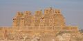
The Sammas overthrew the Soomras soon after 1335 and the last Soomra ruler took shelter with the governor of Gujarat, under the protection of Muhammad bin Tughluq, the sultan of Delhi.[68][69][70] Mohammad bin Tughlaq made an expedition against Sindh in 1351 and died at Sondha, possibly in an attempt to restore the Soomras. With this, the Sammas became independent. The next sultan, Firuz Shah Tughlaq attacked Sindh in 1365 and 1367, unsuccessfully, but with reinforcements from Delhi he later obtained Banbhiniyo's surrender. For a period the Sammas were therefore subject to Delhi again. Later, as the Sultanate of Delhi collapsed they became fully independent.[71] Jam Unar was the founder of Samma dynasty mentioned by Ibn Battuta.[72] The Samma civilization contributed significantly to the evolution of the Indo-Islamic architectural style. Thatta is famous for its necropolis, which covers 10 square km on the Makli Hill.[73] It has left its mark in Sindh with magnificent structures including the Makli Necropolis of its royals in Thatta.[74][75] They were later overthrown by the Turkic Arghuns in the late 15th century.[76][77]
. . . . . . . . . . . . . . . . . . . . . . . . . . . . . . . . . . . . . . . . . . . . . . . . . . . . . . . . . . . . . . . . . . . . . . . . . . . . . . . . . . . . . . . . . . . . . . . . . . . . . . . . . . . . . . . . . . . . . . . . . . . . . . . . . . . . . . . . . . . . . . . . . . . . . . . . . . . . . . . . . . . . . . . .
عهد المغول
In the late 16th century, Sindh was brought into the Mughal Empire by Akbar, himself born in the Rajputana kingdom in Umerkot in Sindh.[78][79] Mughal rule from their provincial capital of Thatta was to last in lower Sindh until the early 18th century, while upper Sindh was ruled by the indigenous Kalhora dynasty holding power, consolidating their rule from their capital of Khudabad, before shifting to Hyderabad from 1768 onwards.[80][81][82]
The Talpurs succeeded the Kalhoras and four branches of the dynasty were established.[83] One ruled lower Sindh from the city of Hyderabad, another ruled over upper Sindh from the city of Khairpur, a third ruled around the eastern city of Mirpur Khas, and a fourth was based in Tando Muhammad Khan. They were ethnically Baloch,[84] and for most of their rule, they were subordinate to the Durrani Empire and were forced to pay tribute to them.[85][86]
They ruled from 1783, until 1843, when they were in turn defeated by the British at the Battle of Miani and Battle of Dubbo.[87] The northern Khairpur branch of the Talpur dynasty, however, continued to maintain a degree of sovereignty during British rule as the princely state of Khairpur,[84] whose ruler elected to join the new Dominion of Pakistan in October 1947 as an autonomous region, before being fully amalgamated into West Pakistan in 1955.
الراج البريطاني

The British conquered Sindh in 1843. General Charles Napier is said to have reported victory to the Governor General with a one-word telegram, namely "Peccavi" – or "I have sinned" (Latin).[88] The British had two objectives in their rule of Sindh: the consolidation of British rule and the use of Sindh as a market for British products and a source of revenue and raw materials. With the appropriate infrastructure in place, the British hoped to utilise Sindh for its economic potential.[89] The British incorporated Sindh, some years later after annexing it, into the Bombay Presidency. Distance from the provincial capital, Bombay, led to grievances that Sindh was neglected in contrast to other parts of the Presidency. The merger of Sindh into Punjab province was considered from time to time but was turned down because of British disagreement and Sindhi opposition, both from Muslims and Hindus, to being annexed to Punjab.[89]
Later, desire for a separate administrative status for Sindh grew. At the annual session of the Indian National Congress in 1913, a Sindhi Hindu put forward the demand for Sindh's separation from the Bombay Presidency on the grounds of Sindh's unique cultural character. This reflected the desire of Sindh's predominantly Hindu commercial class to free itself from competing with the more powerful Bombay's business interests.[89] Meanwhile, Sindhi politics was characterised in the 1920s by the growing importance of Karachi and the Khilafat Movement.[90] A number of Sindhi pirs, descendants of Sufi saints who had proselytised in Sindh, joined the Khilafat Movement, which propagated the protection of the Ottoman Caliphate, and those pirs who did not join the movement found a decline in their following.[91] The pirs generated huge support for the Khilafat cause in Sindh.[92] Sindh came to be at the forefront of the Khilafat Movement.[93]
Although Sindh had a cleaner record of communal harmony than other parts of India, the province's Muslim elite and emerging Muslim middle class demanded separation of Sindh from Bombay Presidency as a safeguard for their own interests. In this campaign, local Sindhi Muslims identified ‘Hindu’ with Bombay instead of Sindh. Sindhi Hindus were seen as representing the interests of Bombay instead of the majority of Sindhi Muslims. Sindhi Hindus, for the most part, opposed the separation of Sindh from Bombay.[89] Although Sindh had a culture of religious syncretism, communal harmony and tolerance due to Sindh's strong Sufi culture in which both Sindhi Muslims and Sindhi Hindus partook,[94] both the Muslim landed elite, waderas, and the Hindu commercial elements, banias, collaborated in oppressing the predominantly Muslim peasantry of Sindh who were economically exploited.[95] Sindhi Muslims eventually demanded the separation of Sindh from the Bombay Presidency, a move opposed by Sindhi Hindus.[92][96][97]
In Sindh's first provincial election after its separation from Bombay in 1936, economic interests were an essential factor of politics informed by religious and cultural issues.[98] Due to British policies, much land in Sindh was transferred from Muslim to Hindu hands over the decades.[99] Religious tensions rose in Sindh over the Sukkur Manzilgah issue where Muslims and Hindus disputed over an abandoned mosque in proximity to an area sacred to Hindus. The Sindh Muslim League exploited the issue and agitated for the return of the mosque to Muslims. Consequentially, a thousand members of the Muslim League were imprisoned. Eventually, due to panic the government restored the mosque to Muslims.[98]The separation of Sindh from Bombay Presidency triggered Sindhi Muslim nationalists to support the Pakistan Movement. Even while the Punjab and North-West Frontier Province were ruled by parties hostile to the Muslim League, Sindh remained loyal to Jinnah.[100] Although the prominent Sindhi Muslim nationalist G.M. Syed left the All India Muslim League in the mid-1940s and his relationship with Jinnah never improved, the overwhelming majority of Sindhi Muslims supported the creation of Pakistan, seeing in it their deliverance.[90] Sindhi support for the Pakistan Movement arose from the desire of the Sindhi Muslim business class to drive out their Hindu competitors.[101] The Muslim League's rise to becoming the party with the strongest support in Sindh was in large part linked to its winning over of the religious pir families.[102] Although the Muslim League had previously fared poorly in the 1937 elections in Sindh, when local Sindhi Muslim parties won more seats,[102] the Muslim League's cultivation of support from local pirs in 1946 helped it gain a foothold in the province,[103] it didn't take long for the overwhelming majority of Sindhi Muslims to campaign for the creation of Pakistan.[104][105]
Partition (1947)
In 1947, violence did not constitute a major part of the Sindhi partition experience, unlike in Punjab. There were very few incidents of violence on Sindh, in part due to the Sufi-influenced culture of religious tolerance and in part that Sindh was not divided and was instead made part of Pakistan in its entirety. Sindhi Hindus who left generally did so out of a fear of persecution, rather than persecution itself, because of the arrival of Muslim refugees from India. Sindhi Hindus differentiated between the local Sindhi Muslims and the migrant Muslims from India. A large number of Sindhi Hindus travelled to India by sea, to the ports of Bombay, Porbandar, Veraval and Okha.[106]
التاريخ الحديث بعد استقلال پاكستان
قرار پاكستان في برلمان السند
الجغرافيا
تقع السند في الركن الغربي من جنوب آسيا، ويحدها المشهد الإيراني من الغرب. جغرافيا، هي ثالث أكبر أقاليم پاكستان، حيث تشغل مساحة 579 كم من الشمال إلى الجنوب و 442 كم (extreme) أو 281 كم (متوسط) من الشرق إلى الغرب، بمساحة 140.915 كم² (54,407 ميل²) من أراضي پاكستان. ويحدها صحراء ثار من الشرق، وجبال كرثار من الغرب، وبحر العرب من الجنوب. وهي مركز السهل الخصيب المحيط بنهر الإندوس.
يتألف الإقليم من ثلاث وحدات تضريسية تتخذ شكل أحزمة متوازية ممتدة من الشمال إلى الجنوب، وهي:
- سهل فيضي منبسط في الوسط (سهل السند)، شكّله نهر السند بفيضاناته المتكررة في الماضي.
- سلسلة جبال كيرثار Kirthar في الجزء الغربي، بارتفاع متدرج من الجنوب (600م نحو مستوى سطح البحر) نحو الشمال (1500م فوق سطح البحر).
- الصحراء الشرقية وهي امتداد غربي لصحراء ثار الهندية.
وأهم ما في الإقليم السهل الفيضي الأوسط ذو التربة اللحقية الخصبة والمستغل زراعياً بكثافة، والذي لا يزيد ارتفاعه على200م.
ويقسم إلى ثلاث مناطق: الشمال ويعرف باسم سيرو Siro، والوسط ويعرف باسم فيخول Vichole، والجنوب ويعرف باسم لار Larr، كما تتألف سلسلة كيرثار من ثلاثة صفوف متوازية من الحافات الجبلية التي يغلب عليها الجفاف والقحولة. وتكون الصحراء الشرقية أكثر جفافاً في الشمال، حيث تكثر فيها تلال الكثبان الرملية.
. . . . . . . . . . . . . . . . . . . . . . . . . . . . . . . . . . . . . . . . . . . . . . . . . . . . . . . . . . . . . . . . . . . . . . . . . . . . . . . . . . . . . . . . . . . . . . . . . . . . . . . . . . . . . . . . . . . . . . . . . . . . . . . . . . . . . . . . . . . . . . . . . . . . . . . . . . . . . . . . . . . . . . . .
الطقس

تتميز السند بمناخها شبه الاستوائي بصيف حار وشتاء بارد. وتتراوحد درجات الحرارة ما بين 46 °C (115 °F) في مايو واغسطس، وأقل درجة حرارة 2 °C (36 °F) في فصل الشتاء ما بين ديسمبر ويناير. ومتوسط نسبة سقوط الأمطار تصل حوالي 7 بوصة، وتكون خلال يوليو-أغسطس.
ينتمي الإقليم إلى المناخ شبه المداري الموسمي، لوقوعه بين خطي عرض 40 َ 23 ْ، 30 َ 28 ْ شمالاً. وتسيطر عليه صفة الجفاف، لأن كمية الأمطار السنوية تقل عن 250مم، والشتاء بارد نسبياً وجاف، تسوده الرياح الشمالية الشرقية الباردة الجافة، والصيف ماطر حار، حيث الرياح الموسمية الجنوبية الغربية. والحرارة مرتفعة عموماً، فهي تراوح في آخر شهور السنة بين 30 ْم على الساحل و33 ْم في الداخل، وفي الشتاء يراوح متوسطها بين 18 ْم على الساحل و15ْم في الداخل، ومع وصول الحرارة المرتفعة صيفاً في الأجزاء الداخلية الشمالية الشرقية إلى أكثر من 50 ْم. تكون الرطوبة النسبية منخفضة بعيداً عن الساحل، ولكنها مرتفعة عند ساحل البحر. وفي كراتشي، يكون متوسط حرارة شهر كانون الثاني 18.9 ْم وتموز 30 ْم، مع متوسط كمية أمطار سنوية تبلغ 196مم، يهطل 75% منها في أشهر حزيران وتموز وآب وأيلول.
الديموغرافيا والمجتمع
| مؤشرات ديموغرافيا لاسند | |
|---|---|
| المؤشر | الإحصائي |
| سكان الحضر | 49.00% |
| سكان الريف | 51.00% |
| معدل النمو السكاني | 2.80% |
| نسبة النوع (ذكر لكل 100 أنثى) | 112.24 |
| السكان النشطين اقتصاديا | 22.75% |
| تاريخ السكان | ||
|---|---|---|
| التقدير | السكان | الحضر |
|
| ||
| 1951 | 6,047,748 | 29.23% |
| 1961 | 8,367,065 | 37.85% |
| 1972 | 14,155,909 | 40.44% |
| 1981 | 19,028,666 | 43.31% |
| 1998 | 30,439,893 | 48.75% |
| 2009 | 35,470,648 | |
الحكومة الإقليمية
الأضلع

أهم المدن
الاقتصاد


الزراعة أساس الاقتصاد السندي، بل اقتصاد الباكستان عموماً. وعلى الرغم مما تعانيه التربة في بعض المناطق من رطوبة شديدة وملوحة، إلا أن عمليات الاستصلاح، ومشاريع الري العديدة، أسهمت في تطور الزراعة تطوراً كبيراً، ومن أهم تلك المشاريع، مشروع سد غودو Gudu ومشروع سد سوكور. ومن أهم المحاصيل الزراعية: القمح، والقطن، والأرز، وقصب السكر، والذرة، وفول الصويا والفواكه والخضراوات. ويربي المزارعون الأبقار والجاموس وكذلك الأغنام والماعز والدواجن. كما يعتمد سكان ساحل بحر العرب على صيد الأسماك، ويصيدون أنواعاً عديدة منها (الروبيان والسردين والقرش)، والإقليم من الأقاليم الرائدة في الصناعة، فكبرى المصانع تتركز في مدينة كراتشي ومحيطها، وفي مدينة حيدر آباد ومدن الشمال، وعلى رأس الصناعات: نسيج القطن، الإسمنت، السكر، المنتجات النفطية، إضافة إلى الصناعات الإلكترونية والميكانيكية، وصناعة القاطرات وغيرها.
المواصلات
تربط مدن الإقليم وقراه شبكة من الخطوط الحديدية، ممثلة بالخط الحديدي الذي ينطلق من مدينة كراتشي إلى حيدر آباد، ومن حيدر آباد يمتد شرقاً إلى الهند، وخطين باتجاه الشمال أحدهما شرقي نهر السند والآخر غربيه إضافة إلى عدد من الطرق البرية الأسفلتية، كما ويستخدم نهر السند للملاحة في الإقليم. ومطار كراتشي هو المطار الرئيس والأكبر في باكستان. وتضم كراتشي العديد من المؤسسات التعليمية العليا، من أهمها جامعة كراتشي، بجانب جامعة السند في حيدر آباد.
الحياة النباتية والحيوانية
| شعار الإقليم | درع السند | |
| علم الإقليم | علم السند | |
| لغة الإقليم | سنڌي (غير رسمي) | 
|
| حيوان الإقليم | Sindh Ibex | |
| طائرة الإقليم | Sind Sparrow | |
| شجرة الإقليم | Capparis decidua | 
|
| زهرة الإقليم | Water Hyacinth |
السكان
| المؤشرات السكانية | |
|---|---|
| تعداد الحضر | 52.02% |
| تعداد الريف | 47.98% |
| معدل النمو السكاني | 2.41% |
| نسبة الجنسين (male per 100 female) | 108.58 |
| Economically active population | 22.75% (Old Data) |
التعداد
| Year | Pop. | ±% |
|---|---|---|
| 1891 | 2٬875٬100 | — |
| 1901 | 3٬210٬910 | +11.7% |
| 1911 | 3٬513٬435 | +9.4% |
| 1921 | 3٬279٬377 | −6.7% |
| 1931 | 3٬887٬070 | +18.5% |
| 1941 | 4٬535٬008 | +16.7% |
| 1951 | 6٬047٬748 | +33.4% |
| 1961 | 8٬367٬065 | +38.4% |
| 1972 | 14٬155٬909 | +69.2% |
| 1981 | 19٬028٬666 | +34.4% |
| 1998 | 29٬991٬161 | +57.6% |
| 2017 | 47٬854٬510 | +59.6% |
| المصدر: الإحصاء في پاكستان, Census of India[108] | ||
Sindh has the second highest Human Development Index out of all of Pakistan's provinces at 0.628.[109] The 2017 Census of Pakistan indicated a population of 47.9 million.
The major ethnic group of the province is the Sindhis, but there is also a significant presence of other groups. Sindhis of Baloch origin make up about 30% of the total Sindhi population (although they speak Sindhi or Saraiki as their native tongue), while Urdu-speaking Muhajirs make up over 19% of the total population of the province, while Punjabi are 10% and Pashtuns represent 7%.[بحاجة لمصدر]
In August 1947, before the partition of India, the total population of Sindh was 3,887,070 out of which 2,832,000 (around 73%) were Muslims, 1,015,000 (around 26%) were Hindus[110] and the remaining were Sikhs and Jains.
يبلغ عدد سكان الإقليم نحو 30 مليون نسمة، حسب تقديرات عام 2003م، وهم خليط من عدة مجموعات عرقية تغلب عليهم الصفة القبلية، ومن أبرز التجمعات القبلية في الإقليم، الميدس Meds والساماس Sammus، والسهتاس Sahtas والبالوش. ومن اللغات المحلية، السندية السيرايكية Seraiki والبالوشية، ويدين أكثر من 98% من السكان بالدين الإسلامي. ويتركز أكثر من 90% من السكان في سهل السند الذي يضم عدداً من المدن الكبيرة، أهمها المدينة الساحلية كراتشي، أكبر مدن الباكستان وأشهرها، بعدد سكان يبلغ نحو 4 ملايين نسمة، يليها مدينة حيدر آباد الواقعة على الضفة الشرقية من نهر السند، ومن المدن المهمة في الجزء الشمالي من سهل السند، جاكوب آباد وشيكابور ولاركانا وسوكور.
Religion

Religion in Sindh according to 2017 census
Islam in Sindh has a long history, starting with the capture of Sindh by Muhammad Bin Qasim in 712 CE. Over time, the majority of the population in Sindh converted to Islam, especially in rural areas. Today, Muslims make up over 90% of the population, and are more dominant in urban than rural areas. Islam in Sindh has a strong Sufi ethos with numerous Muslim saints and mystics, such as the Sufi poet Shah Abdul Latif Bhittai, having lived in Sindh historically. One popular legend which highlights the strong Sufi presence in Sindh is that 125,000 Sufi saints and mystics are buried on Makli Hill near Thatta.[111] The development of Sufism in Sindh was similar to the development of Sufism in other parts of the Muslim world. In the 16th century two Sufi tareeqat (orders) – Qadria and Naqshbandia – were introduced in Sindh.[112] Sufism continues to play an important role in the daily lives of Sindhis.[113]

Sindh also has Pakistan's highest percentage of Hindu overall, which accounts 8.7% of the population, roughly around 4.2 million people,[114] and 13.3% of the province's rural population as per 2017 Pakistani census report. These numbers also include the scheduled caste population, which stands at 1.7% of the total in Sindh (or 3.1% in rural areas),[115] and is believed to have been under-reported, with some community members instead counted under the main Hindu category.[116] Although, Pakistan Hindu Council claimed that there are 6,842,526 Hindus living in Sindh Province covering around 14.29% of the region's population.[117] Umerkot district in the Thar Desert is Pakistan's only Hindu-majority district. The Shri Ramapir Temple in Tandoallahyar whose annual festival is the second largest Hindu pilgrimage in Pakistan is in Sindh.[118] Sindh is also the only province in Pakistan to have a separate law for governing Hindu marriages.[119]
Per community estimates, there are approximately 10,000 Sikhs in Sindh.[120]
| Religious group |
1941[108] | 1951[121][ب] | 1998[122] | 2017[123][114] | ||||
|---|---|---|---|---|---|---|---|---|
| Pop. | % | Pop. | % | Pop. | % | Pop. | % | |
| Islam |
3,208,325 | 70.75% | 5,535,645 | 91.53% | 27,796,814 | 91.32% | 43,234,107 | 90.34% |
| Hinduism |
1,229,926 | 27.12% | 482,560 | 7.98% | 2,280,842 | 7.49% | 4,176,986 | 8.73% |
| Tribal | 36,819 | 0.81% | N/A | N/A | N/A | N/A | N/A | N/A |
| Sikhism |
31,011 | 0.68% | N/A | N/A | N/A | N/A | N/A | N/A |
| Christianity |
20,209 | 0.45% | 22,601 | 0.37% | 294,885 | 0.97% | 408,301 | 0.85% |
| Zoroastrianism |
3,838 | 0.08% | 5,046 | 0.08% | N/A | N/A | N/A | N/A |
| Jainism |
3,687 | 0.08% | N/A | N/A | N/A | N/A | N/A | N/A |
| Judaism |
1,082 | 0.02% | N/A | N/A | N/A | N/A | N/A | N/A |
| Buddhism |
111 | 0% | 670 | 0.01% | N/A | N/A | N/A | N/A |
| Ahmadiyya |
N/A | N/A | N/A | N/A | 43,524 | 0.14% | 21,661 | 0.05% |
| Others | 0 | 0% | 1,226 | 0.02% | 23,828 | 0.08% | 13,455 | 0.03% |
| Total Population | 4,535,008 | 100% | 6,047,748 | 100% | 30,439,893 | 100% | 47,854,510 | 100% |
Languages
According to the 2017 census, the most widely spoken language in the province is Sindhi, the first language of 62% of the population. It is followed by Urdu (18%), Pashto (5٫5%), Punjabi (5٫3%), Saraiki (2٫2%), Balochi (2%) and Hindko (1٫6).[114][2]
Other minority languages include Kutchi, Gujarati,[124] Aer, Bagri, Bhaya, Brahui, Dhatki, Ghera, Goaria, Gurgula, Jadgali, Jandavra, Jogi, Kabutra, Kachi Koli, Parkari Koli, Wadiyari Koli, Loarki, Marwari, Sansi, and Vaghri.[125]
Karachi city is Sindh's most multiethnic city. Urdu-speakers form a plurality, while Pashtuns are the second-largest group.[126] Sindhis themselves are 10% of the population in Karachi, a number that has increased due to migration of rural Sindhis to the city for work.[114][127]
Geography and nature


Sindh is in the western corner of South Asia, bordering the Iranian plateau in the west. Geographically it is the third largest province of Pakistan, stretching about 579 kilometres (360 mi) from north to south and 442 kilometres (275 mi) (extreme) or 281 kilometres (175 mi) (average) from east to west, with an area of 140,915 square kilometres (54,408 sq mi) of Pakistani territory. Sindh is bounded by the Thar Desert to the east, the Kirthar Mountains to the west and the Arabian Sea and Rann of Kutch to the south. In the centre is a fertile plain along the Indus River.
Sindh is divided into three main geographical regions: Siro ("upper country"), aka Upper Sindh, which is above Sehwan; Vicholo ("middle country"), or Middle Sindh, from Sehwan to Hyderabad; and Lāṟu ("sloping, descending country"), or Lower Sindh, mostly consisting of the Indus Delta below Hyderabad.[128]
Flora

The province is mostly arid with scant vegetation except for the irrigated Indus Valley. The dwarf palm, Acacia Rupestris (kher), and Tecomella undulata (lohirro) trees are typical of the western hill region. In the Indus valley, the Acacia nilotica (babul) (babbur) is the most dominant and occurs in thick forests along the Indus banks. The Azadirachta indica (neem) (nim), Zizyphys vulgaris (bir) (ber), Tamarix orientalis (jujuba lai) and Capparis aphylla (kirir) are among the more common trees.
Mango, date palms and the more recently introduced banana, guava, orange and chiku are the typical fruit-bearing trees. The coastal strip and the creeks abound in semi-aquatic and aquatic plants and the inshore Indus delta islands have forests of Avicennia tomentosa (timmer) and Ceriops candolleana (chaunir) trees. Water lilies grow in abundance in the numerous lake and ponds, particularly in the lower Sindh region.[بحاجة لمصدر]
Fauna

Among the wild animals, the Sindh ibex (sareh), blackbuck, wild sheep (Urial or gadh) and wild bear are found in the western rocky range. The leopard is now rare and the Asiatic cheetah extinct. The Pirrang (large tiger cat or fishing cat) of the eastern desert region is also disappearing. Deer occur in the lower rocky plains and in the eastern region, as do the Striped hyena (charakh), jackal, fox, porcupine, common gray mongoose and hedgehog. The Sindhi phekari, red lynx or Caracal cat, is found in some areas. Phartho (hog deer) and wild bear occur, particularly in the central inundation belt. There are bats, lizards and reptiles, including the cobra, lundi (viper) and the mysterious Sindh krait of the Thar region, which is supposed to suck the victim's breath in his sleep. Some unusual sightings of Asian cheetah occurred in 2003 near the Balochistan border in Kirthar Mountains. The rare houbara bustard find Sindh's warm climate suitable to rest and mate. Unfortunately, it is hunted by locals and foreigners.
Crocodiles are rare and inhabit only the backwaters of the Indus, eastern Nara channel and Karachi backwater. Besides a large variety of marine fish, the plumbeous dolphin, the beaked dolphin, rorqual or blue whale and skates frequent the seas along the Sindh coast. The Pallo (Sable fish), a marine fish, ascends the Indus annually from February to April to spawn. The Indus river dolphin is among the most endangered species in Pakistan and is found in the part of the Indus river in northern Sindh. Hog deer and wild bear occur, particularly in the central inundation belt.
Although Sindh has a semi arid climate, through its coastal and riverine forests, its huge fresh water lakes and mountains and deserts, Sindh supports a large amount of varied wildlife. Due to the semi-arid climate of Sindh the left out forests support an average population of jackals and snakes. The national parks established by the Government of Pakistan in collaboration with many organizations such as World Wide Fund for Nature and Sindh Wildlife Department support a huge variety of animals and birds. The Kirthar National Park in the Kirthar range spreads over more than 3000 km2 of desert, stunted tree forests and a lake. The KNP supports Sindh ibex, wild sheep (urial) and black bear along with the rare leopard. There are also occasional sightings of The Sindhi phekari, ped lynx or Caracal cat. There is a project to introduce tigers and Asian elephants too in KNP near the huge Hub Dam Lake. Between July and November when the monsoon winds blow onshore from the ocean, giant olive ridley turtles lay their eggs along the seaward side. The turtles are protected species. After the mothers lay and leave them buried under the sands the SWD and WWF officials take the eggs and protect them until they are hatched to keep them from predators.
Climate

Sindh lies in a tropical to subtropical region; it is hot in the summer and mild to warm in winter. Temperatures frequently rise above 46 °C (115 °F) between May and August, and the minimum average temperature of 2 °C (36 °F) occurs during December and January in the northern and higher elevated regions. The annual rainfall averages about seven inches, falling mainly during July and August. The southwest monsoon wind begins in mid-February and continues until the end of September, whereas the cool northerly wind blows during the winter months from October to January.
Sindh lies between the two monsoons—the southwest monsoon from the Indian Ocean and the northeast or retreating monsoon, deflected towards it by the Himalayan mountains—and escapes the influence of both. The region's scarcity of rainfall is compensated by the inundation of the Indus twice a year, caused by the spring and summer melting of Himalayan snow and by rainfall in the monsoon season.
Sindh is divided into three climatic regions: Siro (the upper region, centred on Jacobabad), Wicholo (the middle region, centred on Hyderabad), and Lar (the lower region, centred on Karachi). The thermal equator passes through upper Sindh, where the air is generally very dry. Central Sindh's temperatures are generally lower than those of upper Sindh but higher than those of lower Sindh. Dry hot days and cool nights are typical during the summer. Central Sindh's maximum temperature typically reaches 43–44 °C (109–111 °F). Lower Sindh has a damper and humid maritime climate affected by the southwestern winds in summer and northeastern winds in winter, with lower rainfall than Central Sindh. Lower Sindh's maximum temperature reaches about 35–38 °C (95–100 °F). In the Kirthar range at 1,800 m (5,900 ft) and higher at Gorakh Hill and other peaks in Dadu District, temperatures near freezing have been recorded and brief snowfall is received in the winters.
المدن الرئيسية
| قائمة المدن الكبرى في السند | ||||
|---|---|---|---|---|
| الترتيب | المدينة | الأضلع | التعداد | صورة |
| 1 | كراتشي | شرق كراتشي غرب كراتشي جنوب كراتشي وسط كراتشي ملير كورنگي |
21,910,352 | .JPG&filetimestamp=20230428034616&)
|
| 2 | حيدر آباد | حيدر آباد | 1,732,693 | 
|
| 3 | سكهر | سكهر | 499,900 | 
|
| 4 | لاركانه | لاركانه | 490,508 | 
|
| 5 | نوابشاه | الشهيدة بينظير | 279,689 | 
|
| 6 | كوتري | جامشورو | 259,358 | 
|
| 7 | ميرپور خاص | ميرپور خاص | 233,916 | 
|
| المصدر: تعداد پاكستان 2017[130] | ||||
| هذه هي قائمة تعدادات المدن نفسها ولا تضم تعدادات الامتدادات العمرانية. | ||||
Government
Sindh province
| Provincial animal | Sindh ibex |  |
|---|---|---|
| Provincial bird | Black partridge |  |
| Provincial tree | Neem Tree |  |
The Provincial Assembly of Sindh is a unicameral and consists of 168 seats, of which 5% are reserved for non-Muslims and 17% for women. The provincial capital of Sindh is Karachi. The provincial government is led by Chief Minister who is directly elected by the popular and landslide votes; the Governor serves as a ceremonial representative nominated and appointed by the President of Pakistan. The administrative boss of the province who is in charge of the bureaucracy is the Chief Secretary Sindh, who is appointed by the Prime Minister of Pakistan. Most of the influential Sindhi tribes in the province are involved in Pakistan's politics.
In addition, Sindh's politics leans towards the left-wing and its political culture serves as a dominant place for the left-wing spectrum in the country.[134] The province's trend towards the Pakistan Peoples Party (PPP) and away from the Pakistan Muslim League (N) can be seen in nationwide general elections, in which Sindh is a stronghold of the PPP.[134] The PML(N) has a limited support due to its centre-right agenda.[135]
In metropolitan cities such as Karachi and Hyderabad, the MQM (another party of the left with the support of Muhajirs) has a considerable vote bank and support.[134] Minor leftist parties such as the People's Movement also found support in rural areas of the province.[136]
Divisions

In 2008, after the public elections, the new government decided to restore the structure of Divisions of all provinces.[137] In Sindh after the lapse of the Local Governments Bodies term in 2010 the Divisional Commissioners system was to be restored.[138][139][140]
In July 2011, following excessive violence in the city of Karachi and after the political split between the ruling PPP and the majority party in Sindh, the MQM and after the resignation of the MQM Governor of Sindh, PPP and the Government of Sindh decided to restore the commissionerate system in the province. As a consequence, the five divisions of Sindh were restored – namely Karachi, Hyderabad, Sukkur, Mirpurkhas and Larkana with their respective districts. Subsequently, two new divisions have been added in Sindh, Banbore and Nawab Shah/Shaheed Benazirabad division.[141]
Karachi district has been de-merged into its five original constituent districts: Karachi East, Karachi West, Karachi Central, Karachi South and Malir. Recently Korangi has been upgraded to the status of the sixth district of Karachi. These six districts form the Karachi Division now.[142] In 2020, the Kemari District was created after splitting Karachi West District.[143] Currently the Sindh government is planning to divide the Tharparkar district into Tharparkar and Chhachro district.[144]
Districts

| Sr. No. | District | Headquarters | Area (km2) |
Population (in 2017) |
Density (people/km2) |
Division |
|---|---|---|---|---|---|---|
| 1 | Badin | Badin | 6,470 | 1,804,516 | 279 | Banbhore |
| 2 | Dadu | Dadu | 8,034 | 1,550,266 | 193 | Hyderabad |
| 3 | Ghotki | Ghotki | 6,506 | 1,647,239 | 253 | Sukkur |
| 4 | Hyderabad | Hyderabad | 1,022 | 2,201,079 | 2,155 | Hyderabad |
| 5 | Jacobabad | Jacobabad | 2,771 | 1,006,297 | 363 | Larkana |
| 6 | Jamshoro | Jamshoro | 11,250 | 993,142 | 88 | Hyderabad |
| 7 | Karachi Central | Karachi | 62 | 2,972,639 | 48,336 | Karachi |
| 8 | Kashmore (formerly Kandhkot) | Kashmore | 2,551 | 1,089,169 | 427 | Larkana |
| 9 | Khairpur | Khairpur | 15,925 | 2,405,523 | 151 | Sukkur |
| 10 | Larkana | Larkana | 1,906 | 1,524,391 | 800 | Larkana |
| 11 | Matiari | Matiari | 1,459 | 769,349 | 527 | Hyderabad |
| 12 | Mirpur Khas | Mirpur Khas | 3,319 | 1,505,876 | 454 | Mirpur Khas |
| 13 | Naushahro Feroze | Naushahro Feroze | 2,027 | 1,612,373 | 369 | Shaheed Benazir Abad |
| 14 | Shaheed Benazirabad (formerly Nawabshah) | Nawabshah | 4,618 | 1,612,847 | 349 | Shaheed Benazir Abad |
| 15 | Qambar Shahdadkot | Qambar | 5,599 | 1,341,042 | 240 | Larkana |
| 16 | Sanghar | Sanghar | 10,259 | 2,057,057 | 200 | Shaheed Benazir Abad |
| 17 | Shikarpur | Shikarpur | 2,577 | 1,231,481 | 478 | Larkana |
| 18 | Sukkur | Sukkur | 5,216 | 1,487,903 | 285 | Sukkur |
| 19 | Tando Allahyar | Tando Allahyar | 1,573 | 836,887 | 532 | Hyderabad |
| 20 | Tando Muhammad Khan | Tando Muhammad Khan | 1,814 | 677,228 | 373 | Hyderabad |
| 21 | Tharparkar | Mithi | 19,808 | 1,649,661 | 83 | Mirpur Khas |
| 22 | Thatta | Thatta | 7,705 | 979,817 | 127 | Banbhore |
| 23 | Umerkot | Umerkot | 5,503 | 1,073,146 | 195 | Mirpur Khas |
| 24 (22) | Sujawal | Sujawal | 8,699 | 781,967 | 90 | Banbhore |
| 25 (7) | Karachi East | Karachi | 165 | 2,909,921 | 17,625 | Karachi |
| 26 (7) | Karachi South | Karachi | 85 | 1,791,751 | 21,079 | Karachi |
| 27 (7) | Karachi West | Karachi | 630 | 3,914,757 | 6,212 | Karachi |
| 28 (7) | Korangi | Korangi Town | 95 | 2,457,019 | 25,918 | Karachi |
| 29 (7) | Malir | Malir Town | 2,635 | 2,008,901 | 762 | Karachi |
| 30 (7) | Kemari | Karachi | N/A | Karachi |
Lower-level subdivisions
In Sindh, talukas are equivalent to the tehsils used elsewhere in the country, supervisory tapas correspond with the kanungo circles used elsewhere, tapas correspond with the patwar circles used in other provinces, and dehs are equivalent to the mouzas used elsewhere.[145]
Towns and villages
Economy


Education
_of_Karachi_1893.jpg&filetimestamp=20230428034649&)

| Year | Literacy rate |
|---|---|
| 1972 | 60.77 |
| 1981 | 37.5% |
| 1998 | 45.29% |
| 2017 | 54.57%[146] |
The following is a chart of the education market of Sindh estimated by the government in 1998:[147]
| Qualification | Urban | Rural | Total | Enrollment ratio (%) |
|---|---|---|---|---|
| — | 14,839,862 | 15,600,031 | 30,439,893 | — |
| Below Primary | 1,984,089 | 3,332,166 | 5,316,255 | 100.00 |
| Primary | 3,503,691 | 5,687,771 | 9,191,462 | 82.53 |
| Middle | 3,073,335 | 2,369,644 | 5,442,979 | 52.33 |
| Matriculation | 2,847,769 | 2,227,684 | 5,075,453 | 34.45 |
| Intermediate | 1,473,598 | 1,018,682 | 2,492,280 | 17.78 |
| Diploma, Certificate... | 1,320,747 | 552,241 | 1,872,988 | 9.59 |
| BA, BSc... degrees | 440,743 | 280,800 | 721,543 | 9.07 |
| MA, MSc... degrees | 106,847 | 53,040 | 159,887 | 2.91 |
| Other qualifications | 89,043 | 78,003 | 167,046 | 0.54 |
Major public and private educational institutes in Sindh include:
- Adamjee Government Science College
- Aga Khan University
- APIIT
- Applied Economics Research Centre
- Bahria University
- Baqai Medical University
- Chandka Medical College Larkana
- Cadet College Petaro
- College of Digital Sciences
- College of Physicians & Surgeons Pakistan
- COMMECS Institute of Business and Emerging Sciences
- D. J. Science College
- Dawood University of Engineering & Technology
- Defence Authority Degree College for Men
- Dow International Medical College
- Dow University of Health Sciences
- Fatima Jinnah Dental College
- Federal Urdu University
- GBELS Dourai Mahar Taluka Daur Distt: Shaheed Benazirabad
- Ghulam Muhammad Mahar Medical College Sukkur
- Government College for Men Nazimabad
- Government College Hyderabad
- Government College of Commerce & Economics
- Government College of Technology, Karachi
- Government Degree College Matiari
- Government High School Ranipur
- Government Islamia Science College Sukkur
- Government Muslim Science College Hyderabad
- Government National College (Karachi)
- Greenwich University (Karachi)
- Hamdard University
- Hussain Ebrahim Jamal Research Institute of Chemistry
- Imperial Science College Nawabshah
- Indus Valley Institute of Art and Architecture
- Institute of Business Administration, Karachi
- Institute of Business Administration, Sukkar
- Institute of Business Management
- Institute of Industrial Electronics Engineering
- Institute of Sindhology
- Iqra University
- Islamia Science College (Karachi)
- Isra University Hyderabad
- Jinnah Medical & Dental College
- Jinnah Polytechnic Institute
- Jinnah Post Graduate Medical Centre
- Jinnah University for Women
- KANUPP Institute of Nuclear Power Engineering
- Karachi Institute of Economics and Technology
- Karachi School of Business and Leadership
- Liaquat University of Medical & Health Sciences
- Mehran University of Engineering and Technology
- Mohammad Ali Jinnah University
- National Academy of Performing Arts
- National University of Computer and Emerging Sciences
- National University of Modern Languages
- National University of Sciences and Technology
- NED University of Engineering and Technology
- Ojha Institute of Chest Diseases
- PAF Institute of Aviation Technology
- TES Public School, Daur
- Pakistan Navy Engineering College
- Pakistan Shipowners' College
- Pakistan Steel Cadet College
- Peoples Medical College for Girls Nawabshah
- PIA Training Centre Karachi
- Provincial Institute of Teachers Education Nawabshah
- Public School Hyderabad
- Quaid-e-Awam University of Engineering, Science and Technology, Nawabshah
- Rana Liaquat Ali Khan Government College of Home Economics
- Saint Patrick's College, Karachi
- Shah Abdul Latif Bhitai University
- Shaheed Benazir Bhutto Medical College
- Shaheed Zulfiqar Ali Bhutto Institute of Science and Technology
- Sindh Agriculture University
- Sindh Medical College
- Superior College of Science Hyderabad
- Sindh Muslim Law College
- Sir Syed Government Girls College
- Sir Syed University of Engineering and Technology
- St. Joseph's College
- Sukkur Institute of Science & Technology
- Textile Institute of Pakistan
- University of Karachi
- University of Sindh
- Usman Institute of Technology
- Ziauddin Medical University
Culture
.jpg&filetimestamp=20230428034830&)

The rich culture, art and architectural landscape of Sindh have fascinated historians. The culture, folktales, art and music of Sindh form a mosaic of human history.[148]
Cultural heritage


The work of Sindhi artisans was sold in ancient markets of Damascus, Baghdad, Basra, Istanbul, Cairo and Samarkand. Referring to the lacquer work on wood locally known as Jandi, T. Posten (an English traveller who visited Sindh in the early 19th century) asserted that the articles of Hala could be compared with exquisite specimens of China. Technological improvements such as the spinning wheel (charkha) and treadle (pai-chah) in the weaver's loom were gradually introduced and the processes of designing, dyeing and printing by block were refined. The refined, lightweight, colourful, washable fabrics from Hala became a luxury for people used to the woollens and linens of the age.[149]
Non-governmental organisations (NGOs) such as the World Wildlife Fund, Pakistan, play an important role to promote the culture of Sindh. They provide training to women artisans in Sindh so they get a source of income. They promote their products under the name of "Crafts Forever". Many women in rural Sindh are skilled in the production of caps. Sindhi caps are manufactured commercially on a small scale at New Saeedabad and Hala New. Sindhi people began celebrating Sindhi Topi Day on 6 December 2009, to preserve the historical culture of Sindh by wearing Ajrak and Sindhi topi.[150]

Tourism
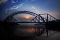
Sukkur Bridge
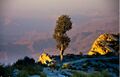
Gorakh Hill Station, Dadu
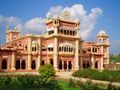
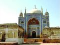
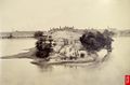
Faiz Mahal, Khairpur
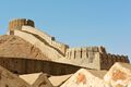
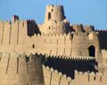
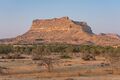
Ranikot Fort, one of the largest forts in the world Thana Bula Khan, Jamshoro
Chaukhandi tombs, Karachi
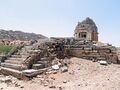
Remains of 9th century Jain temple in Bhodesar, near Nagarparkar
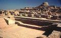
Excavated ruins of Mohenjo-daro
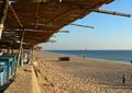
Karachi Beach
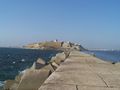
Qasim fort, Manora Island Karachi
Kot Diji, Khairpur
Bakri Waro Lake, Khairpur
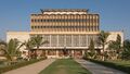
National Museum of Pakistan, Karachi
Kirthar National Park, Thano Bula Khan, Jamshoro
Tomb of Shah Abdul Latif Bhittai, Matiari
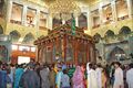
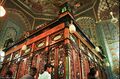
Lal Shahbaz Qalandar, Sehwan Sharif, Jamshoro
Tomb of Mian Noor Muhammad, Benazirabad


See also
- Arab Sind
- Bagh Prints
- Brahma from Mirpur-Khas
- Debal
- Institute of Sindhology
- List of cities in Sindh
- List of cities in Sindh by population
- List of cultural heritage sites in Sindh
- List of medical schools in Sindh
- List of districts of Pakistan
- List of Sindhi people
- Mansura, Sindh
- Mohenjodaro
- Muhajir Sooba
- Provincial Highways of Sindh
- Sind Division
- Sindh cricket team
- Sindhi clothing
- Sindhu Kingdom
- Sufism in Sindh
- Tomb paintings of Sindh
مشاهير السند
أشخاص من التاريخ
- شاه عبد اللطيف بهاياتي
- Sachal Sarmast
- شته عناية الله
- Sami
- Abdullah Shah Ghazi
- Muhammad Ali Jinnah
- Jam Nizamuddin II
- Jam Ferozudin
- Jam Unar
- Jam Sanjar
- Jam Tamachi
- Sardar Darya Khan
- Mian Adam Shah Kalhoro, Amir
- Yar Mouhammed Kalhoro (Khudabad), Amir
- Main Noor Mohammad Kalhoro, Amir
- Mian Ghuam Shah Kalhoro (Shah Wardi Khan), Amir
- Muhammad Muradyab Khan (Nawab Sarbuland Khan), Amir
- Mir Sher Muhammad Talpur
- Gernal Hosh Mohammad Sheedi
- Mir Ali Murad Talpur
- Mir Allahyar Talpur
- Abdul Raheem Grohirri
- صبغة الله شاه رشيدي
- مولانا عبيد الله سندي
- Maulana deen Muhammad Wafai
- Saaen G.M Sayed
Pre-Independence (pre-1947)
- Fatima Jinnah
- السير عبد الله هارون
- قاضي فيض محمد
- Sir Ghulam Hussain Hidayat Ullah
- Allah Bux Soomro
- Raees-Ul-Muhajireen Barrister Jan Muhammad Junejo
- Pir Pagaro
- أغا خان الثالث
- Seth Edulji Dinshaw
- Elsa Kazi
- Khan Bahadur Ghulam Nabi Kazi
- Khan Bahadur Muhmmad Ayub Khuhro
- Pir Illahi Bakhsh
- Allah Bux Soomro
- Abdul Sattar Pirzada
- Khan Sahib Ali Bux Channa
- Nana Ghulam Ally
- Jamshed Nusserwanjee
- Nadirshaw Edulji Dinshaw
- Khan Bahadur Allah Bux Gabole
- K. R. Malkani
- Molana Din Mohammad Wafai
- Syed Hussain Shah He was Pakistan's first boxer to win any medal in olympic boxing
التكنوقراط
محامون وقضاة
- Justice Fakhruddin G Ebrahim
- A K Brohi
- Abdul Hafeez Pirzada
- Justice Tufail Ali Abdul Rehman Zubedi
- Barrister Hassanally A. Rahman Zubedi
- Justice Abdul Hafeez Memon
- Justice Rana Bhagwandas
- Justice Z.A. Channa
- Justice Tufail Ali Abdul Rehman
- Justice Abdul Kadir Sheikh
- Justice Sajjad Ali Shah
- Justice Mamoon Kazi
بعد الإستقلال
- ذو الفقار علي بوتو
- بينظير بوتو
- محمد خان جونيجو
- Rasool Bux Palijo
- Miskeen Jahan Khan Khoso
- Air Marshal M Azim Daudpota
- Aftab Shaban Mirani
- يوسف هارون
- مرتضى بوتو
علماء
- أبو الحسن (أول من ترجم القرآن من اللغة العربية إلى اللغة السندية)
- مولانا عبيد الله سندي
- Hafiz-ul-milat Hafiz Muhammad Siddique Of Bhar Chandi
- Makhdum Muhammad Hashim Thatwi
- Moalana Taj Mohammad Amrothi
- Allama Ghulam Mustafa Qasmi
- Shams-ul-Ulama Mirza Kalich Baig
- Raees-Ul-Muhajireen Barrister Jan Muhammad Junejo
- Shamsul Ulema Dr Umar Bin Muhammad Daudpota
- Allama Ali Khan Abro
- Maulana deen Muhammad Wafai
- Dr. Ghulam Ali Allana
- Allama I. I. Kazi
- Atta Mohammad Hami
- Allama Ali Sher Hydri
- Dr Mubarak Ali
- Makhdoom Bilawal
- Shaikh Mubarak Sindhi
- Makhdoom Muhammad Zaman Talibul Mola
الترفيه
- Abida Parveen
- Mohammed Ali
- Waheed Murad
- Allan Faqir
- Sarmad Sindhi
- Anwar Maqsood
- Moin Akhtar
- Bushra Ansari
- Talat Hussain
- Ahmed Mughal
- Ashiq Nizamani
- Govind Nihalani
- Fozia Soomro
- Jalal Chandio
- Ramesh Sippy
- Mai Bhaggi
- Faisal Malik
- Waqar Zaka
- Professor Ram Panjwani
- Mohammad Ali Charles(Dino)
- Saifudin A. Channa
مؤلفون
- Muhammad Ibrahim Joyo
- Hassam-ud-Din Rashidi
- Dr. Umar Bin Muhammad Daudpota
- Mirza Qalich Baig
- Allama I. I. Kazi
- Qazi Faiz Mohammad
- Nabi Bux Khan Baloch
- Elsa Kazi
- Ali Muhammad Rashidi
- Bedil Masroor
- Jamal Abro
- G.M. Syed
- Agha Salim
- Pir Ali Muhammad Shah Rashidi
- Professor Amina Khamisani-Channa
- Anwar Pirzado
- Kalyan Advani
شعراء
- Shah Abdul Latif Bhitai
- Sachal Sarmast
- Shaikh Ayaz
- Abdul-Qādir Bēdil
- Shah Abdul Karim Bulri
- شاه عناية الله
- عماد حسيني
- Elsa Kazi
- Anwar Pirzado
- Minyoon Shah Inayat
- Behzad Lakhnawi
- Dadan Fakeer
- Adal Soomro
- Ayaz Gul
-
Faiz Mahal, Khairpur
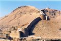
Ranikot Fort, one of the largest forts in the world
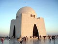
Tomb of M.A. Jinnah in Karachi
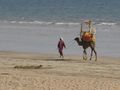
Karachi Beach
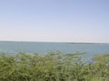
Keenjhar lake Thatta
-
Excavated ruins of Mohenjo-daro
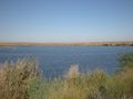
West bank of the River Indus
-
Bakri Waro Lake, Khairpur
Peninsula of Manora
Bhutto family Mausoleum


_of_Karachi_1893.jpg&filetimestamp=20230428034649)
.jpg&filetimestamp=20230428034830)
انظر أيضا
الهوامش
- ^ "Sind - type and level of administrative division". World Gazetteer. Retrieved 2009-08-19.
- ^ أ ب "CCI defers approval of census results until elections". dawn.com. dawn. 2018-05-28. Retrieved 8 August 2019.
- ^ "Sindh (province, Pakistan)" at Britannica Online Encyclopedia
- ^ "About Sindh" at SindhToday.net
- ^ "Provincial Assembly Seats".
- ^ "Government of Sindh".
- ^ Staff reporter (9 March 2014). "Sindh must exploit potential for fruit production". The Nation, 2014. The Nation. Retrieved 29 May 2015.
- ^ Markhand, Ghulam Sarwar; Saud, Adila A. "Dates in Sindh". Proceedings of the International Dates Seminar. SALU Press. Retrieved 29 May 2015.
- ^ Editorial (3 September 2007). "How to grow Bananas". Dawn News, 2007. Dawn News. Retrieved 29 May 2015.
- ^ Quddus, Syed Abdul (1992). Sindh, the Land of Indus Civilisation (in الإنجليزية). Royal Book Company. ISBN 978-969-407-131-2.
- ^ JPRS Report: Near East & South Asia (in الإنجليزية). Foreign Broadcast Information Service. 1992.
- ^ Judy Wakabayashi; Rita Kothari (2009). Decentering Translation Studies: India and Beyond. John Benjamins Publishing. pp. 132–. ISBN 978-90-272-2430-9.
- ^ "Properties inscribed on the World Heritage List (Pakistan)". UNESCO. UNESCO. Retrieved 14 July 2016.
- ^ Choudhary Rahmat Ali (28 January 1933). "Now or Never. Are we to live or perish forever?".
- ^ S. M. Ikram (1 January 1995). Indian Muslims and partition of India. Atlantic Publishers & Dist. pp. 177–. ISBN 978-81-7156-374-6. Retrieved 23 December 2011.
- ^ Phiroze Vasunia 2013, p. 6.
- ^ Southworth, Franklin. The Reconstruction of Prehistoric South Asian Language Contact (1990) p. 228
- ^ Burrow, T. Dravidian Etymology Dictionary Archived 1 مارس 2021 at the Wayback Machine p. 227
- ^ "Sindh, not Sind". The Express Tribune. Web Desk. 12 February 2013. Retrieved 16 October 2015.
- ^ Sanyal, Sanjeev (10 July 2013). Land of the seven rivers : a brief history of India's geography. ISBN 978-0-14-342093-4. OCLC 855957425.
- ^ "Archaeological Ruins at Moanjodaro". The United Nations Educational, Scientific and Cultural Organization (UNESCO) website. Retrieved September 6, 2014.
- ^ "Mohenjo-Daro: An Ancient Indus Valley Metropolis".
- ^ "Mohenjo Daro: Could this ancient city be lost forever?". BBC News (in الإنجليزية البريطانية). 2012-06-26. Retrieved 2022-08-22.
- ^ Edwin Bryant (2001). The Quest for the Origins of Vedic Culture. pp. 159–60.
- ^ Raychaudhuri, Hemchandra (1953). Political History of Ancient India: From the Accession of Parikshit to the Extinction of Gupta Dynasty. University of Calcutta. p. 197.
- ^ أ ب Jain 1974, p. 209-210.
- ^ Sikdar 1964, p. 501-502.
- ^ H.C. Raychaudhuri (1923). Political History of Ancient India: From the Accession of Parikshit to the Extinction of the Gupta Dynasty. University of Calcutta. ISBN 978-1-4400-5272-9.
- ^ M. A. Dandamaev. "A Political History of the Achaemenid Empire" p 147. BRILL, 1989 ISBN 978-9004091726
- ^ "Hidus could be the areas of Sindh, or Taxila and West Punjab." in Cambridge Ancient History (in الإنجليزية). Cambridge University Press. 2002. p. 204. ISBN 9780521228046.
- ^ Rafi U. Samad, The Grandeur of Gandhara: The Ancient Civilization of the Swat, Peshawar, Kabul and Indus Valleys. Algora Publishing, 2011, p. 33 ISBN 0875868592
- ^ Dani, Sindhu-Sauvira 1981, p. 37.
- ^ Eggermont, Alexander's Campaigns in Sind and Baluchistan 1975, p. 13.
- ^ Thorpe 2009, p. 33.
- ^ Rawlinson, H. G. (2001). Intercourse Between India and the Western World: From the Earliest Times of the Fall of Rome (in الإنجليزية). Asian Educational Services. p. 114. ISBN 978-81-206-1549-6.
- ^ Daryaee, Touraj (2014). Sasanian Persia: The Rise and Fall of an Empire (in الإنجليزية). I. B. Tauris. p. 17. ISBN 9780857716668.
- ^ Schindel, Nikolaus; Alram, Michael; Daryaee, Touraj; Pendleton, Elizabeth (2016). The Parthian and Early Sasanian Empires: adaptation and expansion (in الإنجليزية). Oxbow Books. pp. 126–129. ISBN 9781785702105.
- ^ أ ب Wink 1996, pp. 133, 152-153.
- ^ Asif 2016, pp. 65, 81-82, 131-134.
- ^ Wink 1996, p. 151.
- ^ P. 505 The History of India, as Told by Its Own Historians by Henry Miers Elliot, John Dowson
- ^ Nicholas F. Gier, FROM MONGOLS TO MUGHALS: RELIGIOUS VIOLENCE IN INDIA 9TH-18TH CENTURIES, presented at the Pacific Northwest Regional Meeting American Academy of Religion, Gonzaga University, May 2006 [1]. Retrieved 11 December 2006.
- ^ Naik, C.D. (2010). Buddhism and Dalits: Social Philosophy and Traditions. Delhi: Kalpaz Publications. p. 32. ISBN 978-81-7835-792-8.
- ^ P. 164 Notes on the religious, moral, and political state of India before the Mahomedan invasion, chiefly founded on the travels of the Chinese Buddhist priest Fai Han in India, A.D. 399, and on the commentaries of Messrs. Remusat, Klaproth and Burnouf, Lieutenant-Colonel W.H. Sykes by Sykes, Colonel;
- ^ Wink 1991, pp. 152-153.
- ^ El Hareir, Idris; Mbaye, Ravane (2012), The Spread of Islam Throughout the World, UNESCO, p. 602, ISBN 978-92-3-104153-2, https://books.google.com/books?id=qVYT4Kraym0C&pg=PA602
- ^ أ ب MacLean, Derryl N. (1989), Religion and Society in Arab Sind, pp. 126, BRILL, ISBN 90-04-08551-3
- ^ S. A. A. Rizvi, "A socio-intellectual History of Isna Ashari Shi'is in India", Volo. 1, pp. 138, Mar'ifat Publishing House, Canberra (1986).
- ^ S. A. N. Rezavi, "The Shia Muslims", in History of Science, Philosophy and Culture in Indian Civilization, Vol. 2, Part. 2: "Religious Movements and Institutions in Medieval India", Chapter 13, Oxford University Press (2006).
- ^ El Hareir, Idris; Mbaye, Ravane (2012), The Spread of Islam Throughout the World, UNESCO, pp. 601–602, ISBN 978-92-3-104153-2, https://books.google.com/books?id=qVYT4Kraym0C&pg=PA601
- ^ Majumdar, Ramesh Chandra (1976), Readings in political history of India, ancient, mediaeval, and modern, B.R. Pub. Corp., on behalf of Indian Society for Prehistoric and Quaternary Studies, p. 216, https://books.google.com/books?id=YvggAAAAMAAJ
- ^ Tripathi 1967, p. 337.
- ^ Asif 2016, p. 35.
- ^ P. M. ( Nagendra Kumar Singh), Muslim Kingship in India, Anmol Publications, 1999, ISBN 81-261-0436-8, ISBN 978-81-261-0436-9 pg 43-45.
- ^ P. M. ( Derryl N. Maclean), Religion and society in Arab Sindh, Published by Brill, 1989, ISBN 90-04-08551-3, ISBN 978-90-04-08551-0 pg 140-143.
- ^ Abdulla, Ahmed (1987). An Observation: Perspective of Pakistan (in الإنجليزية). Tanzeem Publishers.
- ^ Habib, Irfan (2011). Economic History of Medieval India, 1200-1500 (in الإنجليزية). Pearson Education India. ISBN 978-81-317-2791-1.
- ^ Siddiqui, Habibullah. "The Soomras of Sindh: their origin, main characteristics and rule – an overview (general survey) (1025–1351 CE)" (PDF). Literary Conference on Soomra Period in Sindh.
- ^ "The Arab Conquest". International Journal of Dravidian Linguistics. 36 (1): 91. 2007.
The Soomras are believed to be Parmar Rajputs found even today in Rajasthan, Saurashtra, Kutch and Sindh. The Cambridge History of India refers to the Soomras as "a Rajput dynasty the later members of which accepted Islam" (p. 54 ).
- ^ Dani, Ahmad Hasan (2007). History of Pakistan: Pakistan through ages (in الإنجليزية). Sang-e Meel Publications. p. 218. ISBN 978-969-35-2020-0.
But as many kings of the dynasty bore Hindu names, it is almost certain that the Soomras were of local origin. Sometimes they are connected with Paramara Rajputs, but of this there is no definite proof.
- ^ أ ب Collinet, Annabelle (2008). "Chronology of Sehwan Sharif through Ceramics (The Islamic Period)". In Boivin, Michel (ed.). Sindh through history and representations : French contributions to Sindhi studies (in الإنجليزية). Karachi: Oxford University Press. pp. 9, 11, 113 (note 43). ISBN 978-0-19-547503-6.
- ^ Boivin, Michel (2008). "Shivaite Cults And Sufi Centres: A Reappraisal Of The Medieval Legacy In Sindh". In Boivin, Michel (ed.). Sindh through history and representations : French contributions to Sindhi studies (in الإنجليزية). Karachi: Oxford University Press. p. 30. ISBN 978-0-19-547503-6.
- ^ Collinet, Annabelle (2008). "Chronology of Sehwan Sharif through Ceramics (The Islamic Period)". In Boivin, Michel (ed.). Sindh through history and representations : French contributions to Sindhi studies (in الإنجليزية). Karachi: Oxford University Press. pp. 9, 11, 113 (note 43). ISBN 978-0-19-547503-6.
- ^ Collinet, Annabelle (2008). "Chronology of Sehwan Sharif through Ceramics (The Islamic Period)". In Boivin, Michel (ed.). Sindh through history and representations : French contributions to Sindhi studies (in الإنجليزية). Karachi: Oxford University Press. pp. 9, 11, 113 (note 43). ISBN 978-0-19-547503-6.
- ^ Boivin, Michel (2008). "Shivaite Cults And Sufi Centres: A Reappraisal Of The Medieval Legacy In Sindh". In Boivin, Michel (ed.). Sindh through history and representations : French contributions to Sindhi studies (in الإنجليزية). Karachi: Oxford University Press. p. 30. ISBN 978-0-19-547503-6.
- ^ Aniruddha Ray (4 March 2019). The Sultanate of Delhi (1206-1526): Polity, Economy, Society and Culture. Taylor & Francis. pp. 43–. ISBN 978-1-00-000729-9.
- ^ "Historical Monuments at Makli, Thatta".
- ^ Census Organization (Pakistan); Abdul Latif (1976). Population Census of Pakistan, 1972: Larkana. Manager of Publications.
- ^ Rapson, Edward James; Haig, Sir Wolseley; Burn, Sir Richard; Dodwell, Henry (1965). The Cambridge History of India: Turks and Afghans, edited by W. Haig (in الإنجليزية). Chand. p. 518.
- ^ U. M. Chokshi; M. R. Trivedi (1989). Gujarat State Gazetteer. Director, Government Print., Stationery and Publications, Gujarat State. p. 274.
It was the conquest of Kutch by the Sindhi tribe of Sama Rajputs that marked the emergence of Kutch as a separate kingdom in the 14th century.
- ^ Directions in the History and Archaeology of Sindh by M. H. Panhwar
- ^ Directions in the History and Archaeology of Sindh by M. H. Panhwar
- ^ Archnet.org: Thattah Archived 2012-06-06 at the Wayback Machine
- ^ Census Organization (Pakistan); Abdul Latif (1976). Population Census of Pakistan, 1972: Larkana. Manager of Publications.
- ^ Population Census of Pakistan, 1972: Jacobabad
- ^ The Travels of Marco Polo - Complete (Mobi Classics) By Marco Polo, Rustichello of Pisa, Henry Yule (Translator)
- ^ Bosworth, "New Islamic Dynasties," p. 329
- ^ Tarling, Nicholas (1999). The Cambridge History of Southeast Asia by Nicholas Tarling p.39. ISBN 9780521663700.
- ^ "Hispania [Publicaciones periódicas]. Volume 74, Number 3, September 1991". Biblioteca Virtual Miguel de Cervantes. Archived from the original on 24 September 2015. Retrieved 27 January 2016.
- ^ Brohī, ʻAlī Aḥmad (1998). The Temple of Sun God: Relics of the Past (in الإنجليزية). Sangam Publications. p. 175.
Kalhoras a local Sindhi tribe of Channa origin...
- ^ Burton, Richard Francis (1851). Sindh, and the Races that Inhabit the Valley of the Indus (in الإنجليزية). W. H. Allen. p. 410.
Kalhoras...were originally Channa Sindhis , and therefore converted Hindoos.
- ^ Verkaaik, Oskar (2004). Migrants and Militants: Fun and Urban Violence in Pakistan. Princeton University Press. pp. 94, 99. ISBN 978-0-69111-709-6.
The area of the Hindu-built mansion Pakka Qila was built in 1768 by the Kalhora kings, a local dynasty of Arab origin that ruled Sindh independently from the decaying Moghul Empire beginning in the mid-eighteenth century.
- ^ "History of Khairpur and the royal Talpurs of Sindh". Daily Times (in الإنجليزية الأمريكية). 2018-04-21. Retrieved 2020-03-06.
- ^ أ ب Solomon, R. V.; Bond, J. W. (2006). Indian States: A Biographical, Historical, and Administrative Survey (in الإنجليزية). Asian Educational Services. ISBN 978-81-206-1965-4.
- ^ Baloch, Inayatullah (1987). The Problem of "Greater Baluchistan": A Study of Baluch Nationalism. Steiner Verlag Wiesbaden. p. 121. ISBN 9783515049993.
- ^ Ziad, Waleed (2021). Hidden Caliphate: Sufi Saints Beyond the Oxus and Indus. Harvard University Press. p. 53. ISBN 9780674248816.
- ^ "The Royal Talpurs of Sindh - Historical Background". www.talpur.org. 24 July 2002. Retrieved 2020-02-23.
- ^ General Napier apocryphally reported his conquest of the province to his superiors with the one-word message peccavi, a schoolgirl's pun recorded in Punch (magazine) relying on the Latin word's meaning, "I have sinned", homophonous to "I have Sindh". Eugene Ehrlich, Nil Desperandum: A Dictionary of Latin Tags and Useful Phrases [Original title: Amo, Amas, Amat and More], BCA 1992 [1985], p. 175.
- ^ أ ب ت ث Roger D. Long; Gurharpal Singh; Yunas Samad; Ian Talbot (8 October 2015), State and Nation-Building in Pakistan: Beyond Islam and Security, Routledge, pp. 102–, ISBN 978-1-317-44820-4, https://books.google.com/books?id=nzivCgAAQBAJ&pg=PA102
- ^ أ ب I. Malik (3 June 1999), Islam, Nationalism and the West: Issues of Identity in Pakistan, Palgrave Macmillan UK, pp. 56–, ISBN 978-0-230-37539-0, https://books.google.com/books?id=oyWBDAAAQBAJ&pg=PA56
- ^ Gail Minault (1982), The Khilafat Movement: Religious Symbolism and Political Mobilization in India, Columbia University Press, pp. 105–, ISBN 978-0-231-05072-2, https://books.google.com/books?id=gAW8GreFqjkC&pg=PA105
- ^ أ ب Ansari 1992, p. 77.
- ^ Pakistan Historical Society (2007), Journal of the Pakistan Historical Society, Pakistan Historical Society., p. 245, https://books.google.com/books?id=j_svAQAAIAAJ
- ^ Priya Kumar & Rita Kothari (2016) Sindh, 1947 and Beyond, South Asia: Journal of South Asian Studies, 39:4, 775, DOI:10.1080/00856401.2016.1244752
- ^ Ayesha Jalal (4 January 2002). Self and Sovereignty: Individual and Community in South Asian Islam Since 1850. Routledge. pp. 415–. ISBN 978-1-134-59937-0.
- ^ Roger D. Long; Gurharpal Singh; Yunas Samad; Ian Talbot (8 October 2015). State and Nation-Building in Pakistan: Beyond Islam and Security. Routledge. pp. 102–. ISBN 978-1-317-44820-4.
- ^ Pakistan Historical Society (2007). Journal of the Pakistan Historical Society. Pakistan Historical Society. p. 245.
- ^ أ ب Jalal 2002, p. 415
- ^ Amritjit Singh; Nalini Iyer; Rahul K. Gairola (15 June 2016), Revisiting India's Partition: New Essays on Memory, Culture, and Politics, Lexington Books, pp. 127–, ISBN 978-1-4985-3105-4, https://books.google.com/books?id=tmA0DAAAQBAJ&pg=PA127
- ^ Khaled Ahmed (18 August 2016), Sleepwalking to Surrender: Dealing with Terrorism in Pakistan, Penguin Books Limited, pp. 230–, ISBN 978-93-86057-62-4, https://books.google.com/books?id=TbzBDAAAQBAJ&pg=PT230
- ^ Veena Kukreja (24 February 2003), Contemporary Pakistan: Political Processes, Conflicts and Crises, SAGE Publications, pp. 138–, ISBN 978-0-7619-9683-5, https://books.google.com/books?id=dp05sFFSAbIC&pg=PA138
- ^ أ ب Ansari 1992, p. 115.
- ^ Ansari 1992, p. 122.
- ^ I. Malik (3 June 1999). Islam, Nationalism and the West: Issues of Identity in Pakistan. Palgrave Macmillan UK. pp. 56–. ISBN 978-0-230-37539-0.
- ^ Veena Kukreja (24 February 2003). Contemporary Pakistan: Political Processes, Conflicts and Crises. SAGE Publications. pp. 138–. ISBN 978-0-7619-9683-5.
- ^ Priya Kumar & Rita Kothari (2016) Sindh, 1947 and Beyond, South Asia: Journal of South Asian Studies, 39:4, 776-777, DOI: 10.1080/00856401.2016.1244752
- ^ District Nazims of the Province of Sindh
- ^ أ ب "CENSUS OF INDIA, 1941 VOLUME XII SIND" (PDF). Retrieved 25 September 2021.
- ^ "Social Policy and Development Centre |" (PDF). www.spdc.org.pk. Archived from the original (PDF) on 21 May 2009.
- ^ Rahimdad Khan Molai Shedai; Janet ul Sindh; 3rd edition, 1993; Sindhi Adbi Board, Jamshoro; page no: 2.
- ^ Annemarie Schimmel, Pearls from Indus Jamshoro, Sindh, Pakistan: Sindhi Adabi Board (1986). See pp. 150.
- ^ "History of Sufism in Sindh discussed". DAWN.COM (in الإنجليزية). 2013-09-25. Retrieved 2017-03-30.
- ^ "Can Sufism save Sindh?". DAWN.COM (in الإنجليزية). 2015-02-02. Retrieved 2017-03-30.
- ^ أ ب ت ث "SALIENT FEATURES OF FINAL RESULTS CENSUS-2017" (PDF). Archived from the original (PDF) on 29 August 2021. Retrieved 20 May 2021.
- ^ "Religion in Pakistan (2017 Census)" (PDF). Pakistan Bureau of Statistics. Archived from the original (PDF) on 29 March 2020. Retrieved 2018-03-28.
- ^ "Scheduled castes have a separate box for them, but only if anybody knew". Retrieved 19 September 2020.
- ^ "Hindu Population (PK)". Pakistanhinducouncil.org.pk. Archived from the original on 15 August 2020. Retrieved 2022-06-24.
{{cite web}}: CS1 maint: unfit URL (link) - ^ "Hindu's converge at Ramapir Mela near Karachi seeking divine help for their security". The Times of India. 26 September 2012. Retrieved 2020-10-13.
- ^ Shahid Jatoi (8 June 2017). "Sindh Hindu Marriage Act—relief or restraint?". Express Tribune. Retrieved 10 November 2020.
- ^ Tunio, Hafeez (31 May 2020). "Shikarpur's Sikhs serve humanity beyond religion". The Express Tribune. Pakistan. Retrieved 2 July 2020.
- ^ "CENSUS OF PAKISTAN, 1951 POPULATION ACCORDING TO RELIGION TABLE 6" (PDF). Retrieved 24 January 2023.
- ^ "Population Distribution by Religion, 1998 Census" (PDF). Retrieved 23 January 2023.
- ^ "TABLE 9 - POPULATION BY SEX, RELIGION AND RURAL/URBAN" (PDF). Retrieved 23 January 2023.
- ^ Rehman, Zia Ur (18 August 2015). "With a handful of subbers, two newspapers barely keeping Gujarati alive in Karachi". The News International. Retrieved 13 January 2017.
In Pakistan, the majority of Gujarati-speaking communities are in Karachi including Dawoodi Bohras, Ismaili Khojas, Memons, Kathiawaris, Katchhis, Parsis (Zoroastrians) and Hindus, said Gul Hasan Kalmati, a researcher who authored "Karachi, Sindh Jee Marvi", a book discussing the city and its indigenous communities. Although there are no official statistics available, community leaders claim that there are three million Gujarati-speakers in Karachi – roughly around 15 percent of the city's entire population.
- ^ Eberhard, David M.; Simons, Gary F.; Fennig, Charles D., eds. (2019). "Pakistan - Languages". Ethnologue (22nd ed.).
- ^ "Political and ethnic battles turn Karachi into Beirut of South Asia " Crescent". Merinews.com. Archived from the original on 30 November 2012. Retrieved 2012-11-24.
- ^ Karachi in the Twenty-First Century: Political, Social, Economic and Security Dimensions. 2016-02-22. ISBN 9781443889346.
- ^ Haig, Malcolm Robert (1894). The Indus Delta Country: A Memoir, Chiefly on Its Ancient Geography and History. London: Kegan Paul, Trench, Trübner & Co. p. 1. Retrieved 29 January 2022.
- ^ Menon, Sunita. "Queen of Mangoes: Sindhri from Pakistan now in UAE". Khaleej Times. Retrieved 2019-09-22.
- ^ "Pakistan Bureau of Statistics – 6th Population and Housing Census". www.pbscensus.gov.pk. Archived from the original on 15 October 2017. Retrieved 3 September 2017.
- ^ Ilyas, Faiza (10 July 2012). "Provincial mammal, bird notified". Dawn. Retrieved 3 November 2016.
- ^ "Govt declares Neem 'provincial tree'". Dawn. 15 April 2010. Retrieved 6 September 2014.
- ^ Amar Guriro (14 December 2011). "Our Sindhi symbols – ibex, black partridge". Pakistan Today. Retrieved 6 September 2014.
- ^ أ ب ت Sheikh, Yasir (5 November 2012). "Areas of political influence in Pakistan: right-wing vs left-wing". Karachi, Sindh: Rug Pandits, Yasir. Retrieved 29 May 2015.
- ^ Rehman, Zia ur (2015-05-26). "PML-N braving silent rebellion in Sindh and Karachi leaderships". News International. Archived from the original on 29 May 2015. Retrieved 29 May 2015.
- ^ Sodhar, Muhammad Qasim. "Turn Right: Sindhi Nationalism and Electoral Politics". Tanqeed, Sodhar. Archived from the original on 2015-05-30. Retrieved 29 May 2015.
- ^ "Commissionerate system restored". Archived from the original on 2010-01-09.
- ^ "502 Bad Gateway". www.emoiz.com.
- ^ "Commissioner system to be restored soon: Durrani". Archived from the original on 2012-07-31.
- ^ "Sindh: Commissioner system may be revived today". Archived from the original on 4 January 2017. Retrieved 25 April 2016.
- ^ "Commissioners, DCs posted in Sindh". Archived from the original on 2011-07-13.
- ^ "Sindh back to 5 divisions after 11 years | Pakistan Today". www.pakistantoday.com.pk.
- ^ ABDULLAH ZAFAR (21 August 2020). "Sindh Cabinet approves division of Karachi into seven districts". nation.com.pk. Retrieved 25 May 2021.
- ^ "Sindh govt to divide Tharparkar in two districts". Retrieved 7 June 2021.
- ^ Khan, Tariq Shafiq (2009). Pakistan 2008 Mouza Statistics (PDF). Government of Pakistan: Statistics Division - Agricultural Census Organization. Archived from the original (PDF) on 12 June 2021. Retrieved 15 May 2021.
- ^ "Archived copy" (PDF). Archived from the original (PDF) on 19 May 2021. Retrieved 14 June 2021.
{{cite web}}: CS1 maint: archived copy as title (link) - ^ "Population by Level of Education and Rural/Urban". Statistics Division: Ministry of Economic Affairs and Statistics. Government of Pakistan. Archived from the original on July 20, 2009. Retrieved 2009-08-19.
- ^ "Spotlighting: Sindh Exhibit provides peek into province's rich culture – The Express Tribune". The Express Tribune (in الإنجليزية الأمريكية). 2013-09-28. Retrieved 2017-03-30.
- ^ "Cultural Heritage". wishwebdesign.com =. Archived from the original on 5 November 2013. Retrieved September 6, 2014.
- ^ "Sindh celebrates first ever 'Sindhi Topi Day'". Archived from the original on 8 December 2009. Retrieved 6 December 2009.
المصادر
- Malkani, Kewal Ram (1984). The Sindh Story. Allied Publishers Pvt. Ltd.
وصلات خارجية
![]() تعريفات قاموسية في ويكاموس
تعريفات قاموسية في ويكاموس
![]() كتب من معرفة الكتب
كتب من معرفة الكتب
![]() اقتباسات من معرفة الاقتباس
اقتباسات من معرفة الاقتباس
![]() نصوص مصدرية من معرفة المصادر
نصوص مصدرية من معرفة المصادر
![]() صور و ملفات صوتية من كومونز
صور و ملفات صوتية من كومونز
![]() أخبار من معرفة الأخبار.
أخبار من معرفة الأخبار.
- Government of Sindh
- Khairpur Sindh Heritage & Welfare NGO
- Dynasties ruling Sindh with some of their coinage and brief history
- Maps of Sindh
- 'Come on Sindh !' - A blog dedicated to the province of Sindh
- Map of the districts of Sindh
- Popular Sindhi Personalities
- Sindh Attractions
- http://www.statpak.gov.pk/depts/pco/statistics
- Shikarpur District
- السند at the Open Directory Project
Sindh travel guide from Wikitravel
خطأ استشهاد: وسوم <ref> موجودة لمجموعة اسمها "lower-alpha"، ولكن لم يتم العثور على وسم <references group="lower-alpha"/>