مسطح المد والجزر
مسطح المد والجزر Mudflat or Tidal flat، منطقة منبسطة من سطح الأرض، يتبادل عليها غمر وانحسار البحر أثناء حركة المد والجزر، تتجمع فوقها رواسب الطين والرمال المفككة، وقد تغطيها الأحراش.[1]

. . . . . . . . . . . . . . . . . . . . . . . . . . . . . . . . . . . . . . . . . . . . . . . . . . . . . . . . . . . . . . . . . . . . . . . . . . . . . . . . . . . . . . . . . . . . . . . . . . . . . . . . . . . . . . . . . . . . . . . . . . . . . . . . . . . . . . . . . . . . . . . . . . . . . . . . . . . . . . . . . . . . . . . .
البيئة
أمثلة لمناطق محددة
- Arcachon Bay، فرنسا
- Banc d'Arguin، موريتانيا
- Great Rann of Kutch, الهند
- Belhaven, East Lothian اسكتلندة، المملكة المتحدة
- Bridgwater Bay و Morecambe Bay، المملكة المتحدة
- Cape Cod Bay، مساتشوستس، الولايات المتحدة
- Cook Inlet، ألاسكا، الولايات المتحدة
- Koojosee Inlet، Nunavut، كندا
- Lindisfarne Island، انگلترا، المملكةالمتحدة
- Minas Basin، Nova Scotia، كندا
- Padilla Bay، واشنطن، الولايات المتحدة
- Plymouth Bay، مساتشوستس، الولايات المتحدة
- Port of Tacoma، واشنطن
- Skagit Bay، واشنطن
- Snettisham Norfolk انگلترا، المملكة المتحدة
- Wadden Sea: Netherlands، ألمانيا، الدنمارك
- West coast of Andros Island, Bahamas
- Yellow Sea، الصين، كوريا
معرض الصور
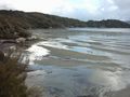
Mudflats near Oban on Stewart Island, New Zealand.
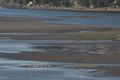
Mudflats in Brewster, Massachusetts، الولايات المتحدة، extending hundreds of yards offshore at the low tide. The line of seashells in the foreground indicates the high water mark.
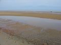
Gulls feeding on mudflats in Skagit Bay, Washington.

The tidal flat in Japan. Twilight of the Kaburasaki(蕪崎) seashore.


انظر أيضا
المصادر
وصلات خارجية
| هذه بذرة مقالة عن موضوع متعلق بالطبوغرافيا تحتاج للنمو والتحسين، ساهم في إثرائها بالمشاركة في تحريرها. |