لوزار (إقليم فرنسي)
لوزار ( Lozère ؛ النطق الفرنسي: [lɔzɛʁ] (![]() استمع); أوكسيتان: Losera [luˈzeɾɔ]) هو إقليم فرنسي حبيس، يقع في جنوبي شرق فرنسا بالقرب من وسط الكتلة الصخرية، سمى باسم لوزار نسبة لجبل لوزار الذي يقع في الإقليم.
استمع); أوكسيتان: Losera [luˈzeɾɔ]) هو إقليم فرنسي حبيس، يقع في جنوبي شرق فرنسا بالقرب من وسط الكتلة الصخرية، سمى باسم لوزار نسبة لجبل لوزار الذي يقع في الإقليم.
Lozère
Losera (أوكسيتان) | |
|---|---|
    From top down, left to right: Sainte-Enimie, the Gorges du Tarn in La Malène, Castle of Florac, Mont Lozère | |
 Flag  Coat of arms | |
 Location of Lozère in France | |
| الإحداثيات: 44°20′N 3°36′E / 44.333°N 3.600°ECoordinates: 44°20′N 3°36′E / 44.333°N 3.600°E | |
| Country | France |
| Region | Occitanie |
| Departement | 4 March 1790 |
| Prefecture | Mende |
| Subprefecture | Florac Trois Rivières |
| الحكومة | |
| • President of the Departmental Council | Sophie Pantel[1] (PS) |
| المساحة | |
| • الإجمالي | 5٬166٫9 كم² (1٬995�0 ميل²) |
| التعداد (يناير 2019) | |
| • الإجمالي | 76٬604 |
| • الترتيب | 102nd |
| • الكثافة | 15/km2 (38/sq mi) |
| صفة المواطن | Lozériens |
| منطقة التوقيت | UTC+1 (CET) |
| • الصيف (التوقيت الصيفي) | UTC+2 (CEST) |
| ISO 3166 code | FR-48 |
| Department number | 48 |
| Arrondissements | 2 |
| Cantons | 13 |
| Communes | 152 |
| الموقع الإلكتروني | lozere.fr |
. . . . . . . . . . . . . . . . . . . . . . . . . . . . . . . . . . . . . . . . . . . . . . . . . . . . . . . . . . . . . . . . . . . . . . . . . . . . . . . . . . . . . . . . . . . . . . . . . . . . . . . . . . . . . . . . . . . . . . . . . . . . . . . . . . . . . . . . . . . . . . . . . . . . . . . . . . . . . . . . . . . . . . . .
التاريخ
إقليم لوزار هي واحد من الأقاليم الـ 83 التي تتشكل منها فرنسا، أنشئت خلال الثورة الفرنسية يوم 4 مارس 1790، تم أنشاؤها من جزء من منطقة لانغدوك السابقة.

وكان وحش جيڤودان (بالفرنسية: Beast of Gévaudan) الذي أصبح جزءا من تاريخ الإقليم، والذي روع المنطقة العامة لمنطقة جيڤودان السابقة، والتي كانت تملك حدود قريبة مع إقليم لوزار، وكان يعيش هذا الوحش في جبال مارجريد في الإطار الزمني بين أعوام 1764-1767.
الجغرافيا
جغرافية إقليم لوزار معقد جدا، حيث تغطية أربعة نطاقات جبلية، ففي الشمال الغربي تقع الهضبة البازلتية على ارتفاع 1000 إلى 1450 م، مع مناخ بارد رطب لتأثره بالمحيط الأطلسي، وفي الشمال والشمال الشرقي من الإقليم تقع جبال ماغريد، التي تتكون من صخور الجرانيت، ولها قمم يبلغ ارتفاعها بين 1،000 و 1،550 متر. أما المناخ فهو بارد ولكنه جاف مع ثلوج أقل.
وفي الغرب والجنوب يحتوي الإقليم على سلسلة هضاب كاوسيس، والجنوب الشرقي يحتوي الإقليم على سلسلة جبال سيفينز والتي تشمل أعلى نقطة في إقليم لوزار حيث تبلغ 1702 م.
The north and north-east of the department contains the Margeride mountains, which are formed of granite, and have peaks between 1,000 and 1,550 m (3,280 and 5,090 ft). The climate here is also cold, but drier than in Aubrac, with less snow.
The Causses are a series of very dry limestone plateaus in the south-west, and the south-east contains the Cévennes, which include the highest point in the department, the granite Mont Lozère at 1,702 m (5,584 ft).
The department also contains numerous rivers, above and below ground, including the Tarn, whose source is on Mont Lozère, and which flows through the Gorges du Tarn in the Causses.

السكان
Population development since 1801:
| التعداد التاريخي | |||||||||||||||||||||||||||||||||||||||||||||||||||||||||||||||||||||||||||||||||||||
|---|---|---|---|---|---|---|---|---|---|---|---|---|---|---|---|---|---|---|---|---|---|---|---|---|---|---|---|---|---|---|---|---|---|---|---|---|---|---|---|---|---|---|---|---|---|---|---|---|---|---|---|---|---|---|---|---|---|---|---|---|---|---|---|---|---|---|---|---|---|---|---|---|---|---|---|---|---|---|---|---|---|---|---|---|---|
|
| ||||||||||||||||||||||||||||||||||||||||||||||||||||||||||||||||||||||||||||||||||||
| Sources:[3][4] | |||||||||||||||||||||||||||||||||||||||||||||||||||||||||||||||||||||||||||||||||||||
Lozère is the least populated French department. It has a population, in 2019, of 76,604, for a population density of 14٫8 inhabitants/km2. The department boasts a population similar in size to that of the country of Andorra, the neighbouring country that borders to the south. Since the end of the 19th century the department has seen its population decline due to negative migration, the last fifteen years have nevertheless shown a new upward trend. The reasons given for this trend are the quality of the living environment, the improvement of the road transport and communication network and to a lesser extent heliotropism. It is nevertheless an elderly population with high purchasing power. The inhabitants of Lozère are known, in French, as Lozériens and Lozériennes.[5]
ويطلق على سكان إقليم لوزار اسم لوزيريانز (بالفرنسية:Lozériens)، وهي من الأقاليم الفرنسية الأقل سكانا حيث يسكن بها حوالي 73,509 نسمة فقط.
ويعتقد أن انخفاض الكثافة السكانية (14 نسمة / كيلومتر مربع) راجعا إلى التربة في المنطقة، حيث تعد التربة من أفقر الترب الزراعية في فرنسا، وكما أن النزوح القروي والذي كان مرتفعا خصوصا في الزمن الواقع بين 1850 و1910.
في السنوات الأخيرة قد زاد عدد سكان الإقليم قليلا، بسبب أنه يعتقد أن تقدم نوعية وجودة الحياة قد ارتفع، وأيضا نتيجة لتحسين شبكات النقل، ومع ذلك، فإن السكان في الإقليم من كبار السن ومن متوسطي الدخل.
Because of its low population density, it is considered to fall within the empty diagonal.
Principal towns
The most populous commune is Mende, the prefecture. As of 2019, there are 3 communes with more than 3,000 inhabitants:[6]
| Commune | Population (2019) |
|---|---|
| Mende | 12,318 |
| Marvejols | 4,684 |
| Saint-Chély-d'Apcher | 4,211 |
الإدارة
The département is managed by the Departmental Council of Lozère in Mende. اعتبارا من 2015[تحديث], the President of the council is Sophie Pantel. Lozère is part of the region of Occitanie.
التقسيمات الإدارية
There are 2 arrondissements, 13 cantons and 152 communes in Lozère.[7]
| INSEE code |
Arrondissement | Capital | Population[6] (2019) |
Area (km2) |
Density (inhabitants/km2) |
Communes |
|---|---|---|---|---|---|---|
| 481 | Florac | Florac | 13,050 | 1,687 | 7٫7 | 38 |
| 482 | Mende | Mende | 63,554 | 3,479 | 18٫3 | 114 |
The following is a list of the 13 cantons of the Lozère department (with their INSEE codes), following the French canton reorganisation which came into effect in March 2015:[8]
- Bourgs sur Colagne (4803)
- La Canourgue (4802)
- Le Collet-de-Dèze (4804)
- Florac Trois Rivières (4805)
- Grandrieu (4806)
- Langogne (4807)
- Marvejols (4808)
- Mende-1 (4809)
- Mende-2 (4810)
- Peyre en Aubrac (4801)
- Saint-Alban-sur-Limagnole (4811)
- Saint-Chély-d'Apcher (4812)
- Saint-Étienne-du-Valdonnez (4813)
. . . . . . . . . . . . . . . . . . . . . . . . . . . . . . . . . . . . . . . . . . . . . . . . . . . . . . . . . . . . . . . . . . . . . . . . . . . . . . . . . . . . . . . . . . . . . . . . . . . . . . . . . . . . . . . . . . . . . . . . . . . . . . . . . . . . . . . . . . . . . . . . . . . . . . . . . . . . . . . . . . . . . . . .
الاقتصاد
The main activities are cattle farming and tourism. There is barely any arable farming in Lozère due to poor soil quality. The hardy Aubrac is the most commonly farmed cattle breed here.
The region has one of the lowest rates of unemployment in France, which may be attributed to the enforced long-standing tradition whereby young people emigrate to cities such as Lyon, Marseille, Montpellier when they reach working age.
استخدام الأراضي

Lozère is a rural department, with relatively little land taken up by roads and buildings. Overall the land use is divided as follows:
- Forest 43.81%
- Heath & other open land 31.19%
- Arable land 12.74%
- Fields 11.36%
- Roads and buildings 0.54%
- Rivers and ponds 0.3
السياحة
تشمل الأنشطة السياحية مجموعة متنوعة من الألعاب الرياضية مثل التزحلق على الجليد والتجديف، كما يحتوي إقليم لوزار على جزء من حديقة سيفين الوطنية. وتعتبر لوزار واحدة من أفضل المناطق في فرنسا لصيد سمك السلمون المرقط، وتتواجد بصفة خاصة في الأنهار مثل لوط، وتارن، وتروير.
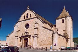
Church of Marvejols
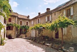
Sainte-Enimie, one of the most beautiful villages of France
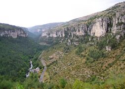
Cévennes National Park


السياسة
Current National Assembly Representative
| Constituency | Member[9] | Party | |
|---|---|---|---|
| Lozère's constituency | Pierre Morel-À-L'Huissier | The Republicans | |
انظر أيضاً
المصادر
وصلات خارجية
- (إنگليزية) Tourism in Lozère - Official site : Gorges du Tarn, Aubrac, Margeride, Cévennes...
- (بالفرنسية) Prefecture website
- (بالفرنسية) Conseil Général website
- (إنگليزية) Lozère on netrando.com
- ^ "Répertoire national des élus: les conseillers départementaux". data.gouv.fr, Plateforme ouverte des données publiques françaises (in الفرنسية). 4 May 2022.
- ^ "Département de La Lozère (48) - Résumé statistique". Publications et statistiques pour la France ou les régions (in الفرنسية). Institut national de la statistique et des études économiques - INSEE. Retrieved 18 August 2015.
- ^ "Historique de la Lozère". Le SPLAF. Retrieved 8 July 2022.
- ^ "Évolution et structure de la population en 2016". INSEE.
- ^ "Lozère (48)" (in الفرنسية). habitants.fr. Retrieved 18 August 2015.
- ^ أ ب خطأ استشهاد: وسم
<ref>غير صحيح؛ لا نص تم توفيره للمراجع المسماةpop2019 - ^ "Département de La Lozère (48)" (in الفرنسية). Institut national de la statistique et des études économiques - INSEE. Retrieved 11 September 2020.
- ^ "Décret n° 2014-245 du 25 février 2014 portant délimitation des cantons dans le département de la Lozère" (in الفرنسية). Légifrance.gouv.fr. Retrieved 18 August 2015.
- ^ Nationale, Assemblée. "Assemblée nationale ~ Les députés, le vote de la loi, le Parlement français". Assemblée nationale.