لنكنشاير
لنكنشاير (إنگليزية: Lincolnshire)، هي مقاطعة إنجليزية تقع في شرق إنجلترا. وتجاور كل من مقاطعات نورفوك وكمبردجشاير ورتلاندشاير وليسترشاير ونوتنگامشاير وجنوب يوركشاير ونورثامپتونشاير. الجزء الشرقي منها يطل على بحر الشمال. ومدينة المقاطعة الرئيسية لنكن.
لنكنشاير
Lincolnshire | |||||||||||||||||||||||||||||||||||||||||||||||||
|---|---|---|---|---|---|---|---|---|---|---|---|---|---|---|---|---|---|---|---|---|---|---|---|---|---|---|---|---|---|---|---|---|---|---|---|---|---|---|---|---|---|---|---|---|---|---|---|---|---|
| الشعار: الأرض والرب | |||||||||||||||||||||||||||||||||||||||||||||||||
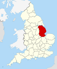 | |||||||||||||||||||||||||||||||||||||||||||||||||
| البلد | المملكة المتحدة | ||||||||||||||||||||||||||||||||||||||||||||||||
| المقاطعة | إنگلترة | ||||||||||||||||||||||||||||||||||||||||||||||||
| المنطقة | شرق ميدلاندز يوركشاير وهمبر (شمال لنكنشاير & شمال شرق لنكنشاير) | ||||||||||||||||||||||||||||||||||||||||||||||||
| منطقة التوقيت | UTC±00:00 (توقيت گرينتش المتوسط) | ||||||||||||||||||||||||||||||||||||||||||||||||
| • الصيف (التوقيت الصيفي) | UTC+01:00 (توقيت بريطانيا الصيفي) | ||||||||||||||||||||||||||||||||||||||||||||||||
| أعضاء البرلمان | |||||||||||||||||||||||||||||||||||||||||||||||||
| |||||||||||||||||||||||||||||||||||||||||||||||||
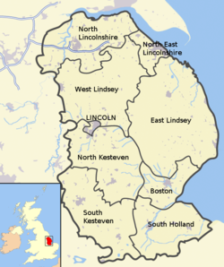
تتكون المقاطعة من ثلاث أقاليم رئيسية هي مقاطعة لنكنشاير وإقليم شمال لنكنشاير المدار ذاتيا وإقليم شمال شرق لنكنشاير المدار ذاتياً. المقاطعة وهي ثاني أكبر مقاطعات من الإنجليزية من حيث المساحة ويغلب عليها الطابع الزراعي.
The county is predominantly rural, with an area of 6,959 km2 (2,687 sq mi) and a population of 1,087,659. After Lincoln (104,555), the largest towns are Grimsby (85,925) and Scunthorpe (81,265).[1] For local government purposes Lincolnshire comprises a non-metropolitan county, with seven districts, and the unitary authority areas of North Lincolnshire and North East Lincolnshire. The last two areas are part of the Yorkshire and the Humber region, and the rest of the county is in the East Midlands.
Lincolnshire is the second-largest ceremonial county and has a varied geography, including the chalk hills of the Lincolnshire Wolds AONB, the wetlands of the Lincolnshire Fens, the Lincoln Cliff escarpment, and the Lincolnshire Marsh.
Lincolnshire has had a comparatively quiet history, being a rural county which was not heavily industrialised and faced little threat of invasion. In the fifth century what would become the county was settled by the invading Angles, who established the Kingdom of Lindsey in the north of the region. The late Middle Ages were a particularly prosperous period, when wealth from wool trade facilitated the building of grand churches such as St Botolph's Church, Boston. During the Second World War the relatively flat topography of the county made it an important base for the Royal Air Force, which built several airfields and based two bomber squadrons in the area.
. . . . . . . . . . . . . . . . . . . . . . . . . . . . . . . . . . . . . . . . . . . . . . . . . . . . . . . . . . . . . . . . . . . . . . . . . . . . . . . . . . . . . . . . . . . . . . . . . . . . . . . . . . . . . . . . . . . . . . . . . . . . . . . . . . . . . . . . . . . . . . . . . . . . . . . . . . . . . . . . . . . . . . . .
History
During pre-Roman times, most of Lincolnshire was inhabited by the Corieltauvi people. The language of the area at that time would have been Common Brittonic, the precursor to modern Welsh. The name Lincoln was derived from Lindum Colonia.
Large numbers of Germanic speakers from continental Europe settled in the region following the withdrawal of the Romans. Though these were later identified as Angles, it is unlikely that they migrated as part of an organized tribal group.[2][3] Thus, the main language of the region quickly became Old English. However, it is possible that Brittonic continued to be spoken in some communities as late as the eighth century.[4]
Modern-day Lincolnshire is derived from the merging of the territory of the Kingdom of Lindsey with that controlled by the Danelaw borough of Stamford. For some time the entire county was called "Lindsey", and it is recorded as such in the 11th-century Domesday Book. Later, the name Lindsey was applied to the northern core, around Lincoln. This emerged as one of the three Parts of Lincolnshire, along with the Parts of Holland in the south-east, and the Parts of Kesteven in the south-west, which each had separate Quarter Sessions as their county administrations. Lindsay was traditionally split between the North, South and West Ridings of Lindsey.
The area was shaken by the 27 February 2008 Lincolnshire earthquake, reaching between 4.7 and 5.3 on the Richter magnitude scale; it was one of the largest earthquakes to affect Britain in recent years.
Lincolnshire is home to Woolsthorpe Manor, birthplace and home of Sir Isaac Newton. He attended The King's School, Grantham. Its library has preserved his signature, carved into a window sill when he was a youth.
Geography
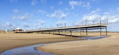
The geographical layout of Lincolnshire is quite extensive and mostly separated by many rivers and rolling countryside. The north of the county begins from where the Isle of Axholme is located near the meeting points of the rivers Ouse and Trent near to the Humber. From there, the southside of the Humber estuary forms the border between Lincolnshire and the East Riding of Yorkshire. From there, the south bank of the Humber Estuary where the Humber Bridge crosses the estuary at Barton upon Humber, is used primarily for the shipping ports at Immingham, New Holland and Grimsby. From there, the rest of the southern bank forms the Lincolnshire Coast from Cleethorpes to Mablethorpe and then onto Skegness. From Skegness, the rest of the Lincolnshire Coastline forms the sea boundary and border with Norfolk at the Wash. The coast then at Boston becomes the meeting point of the rivers Welland and Haven in a area known as the "Fosdyke Wash".
The rest of the sea boundary runs from Fosdyke to the east of Sutton Bridge, where the current land boundary with Norfolk is located in a narrow area of reclaimed farmland just to the east of the River Nene but until as recently as the early 19th century there was no land border between Lincolnshire and Norfolk as it was separated from each other by the "Cross Keys Wash" a former area of estuary and marshland where the River Nene used to flow out into the Wash and could only be crossed at low tide by a causeway or ferry and was the natural boundary between the two counties. The causeway known at the time as the "Wash Way" was renowned as being particularly treacherous and the safer route was to go into Norfolk from Lincolnshire via the Cambridgeshire town of Wisbech and this element remains to the present day as the Cross Keys Bridge at Sutton Bridge provides the only direct access point to Norfolk from Lincolnshire over the River Nene some nine miles north of Wisbech. The border with Lincolnshire to Cambridgeshire begins at Crowland, Market Deeping and Stamford which form the southern boundary of the county with both Peterborough, Rutland and briefly Northamptonshire; the county's border with Northamptonshire is just 20 yards (19 m) long, England's shortest county boundary.[5] From there, the border with Leicestershire and Nottinghamshire begins at Sleaford, Grantham, Lincoln and Gainsborough. From Gainsborough, the border with South Yorkshire begins at Haxey and Epworth before looping back to the original north of the county near Scunthorpe with East Riding of Yorkshire at the Isle of Axholme and Goole.[6][7][8][9][10][11][12][13][14][15][16]
Bedrock in Lincolnshire features Jurassic limestone (near Lincoln) and Cretaceous chalk (north-east). The area around Woodhall Spa and Kirkby on Bain is dominated by gravel and sand.[17] For much of prehistory, Lincolnshire was under tropical seas, and most fossils found in the county are marine invertebrates. Marine vertebrates have also been found including ichthyosaurus and plesiosaur.[18][19]
The highest point in Lincolnshire is Wolds Top (168 m, 551 ft), at Normanby le Wold.[20] Some parts of the Fens may be below sea level. The nearest mountains are in Derbyshire.
The biggest rivers in Lincolnshire are the Trent, running northwards from Staffordshire up the western edge of the county to the Humber estuary, and the Witham, which begins in Lincolnshire at South Witham and runs for 132 km (82 miles) through the middle of the county, eventually emptying into the North Sea at The Wash. The Humber estuary, on Lincolnshire's northern border, is also fed by the River Ouse. The Wash is also the mouth of the Welland, the Nene and the Great Ouse.
Lincolnshire's geography is fairly varied, but consists of several distinct areas:
- Lincolnshire Wolds: area of rolling hills in the north-east of the county designated an Area of Outstanding Natural Beauty
- The Fens: dominating the south-east quarter of the county
- The Marshes: running along the coast of the county
- Lincoln Edge or Cliff: limestone escarpment running north–south along the western half of the county
Lincolnshire's most well-known nature reserves include Gibraltar Point National Nature Reserve, Whisby Nature Park Local Nature Reserve, Donna Nook National Nature Reserve, RSPB Frampton Marsh and the Humberhead Peatlands National Nature Reserve. Although the Lincolnshire countryside is intensively farmed, there are many biodiverse wetland areas[بحاجة لمصدر], as well as rare limewood forests. Much of the county was once wet fenland (see The Fens).
From bones, we can tell that animal species formerly found in Lincolnshire include woolly mammoth, woolly rhinoceros, wild horse, wolf, wild boar and beaver.[21][22] Species which have recently returned to Lincolnshire after extirpation include little egret, Eurasian spoonbill, European otter and red kite.[23][24]
المناطق
تنقسم مقاطعة لنكنشاير إلى تسعة مناطق هي كالتالي:
الاقتصاد
| السنة | القيمة الإجمالية المحلية المضافة (مليون₤)[a] | الزراعة[b] | الصناعة[c] | الخدمات[d] |
|---|---|---|---|---|
| 1995 | 5,719 | 657 | 1,769 | 3,292 |
| 2000 | 6,512 | 452 | 2,046 | 4,013 |
| 2003 | 8,419 | 518 | 2,518 | 5,383 |
- a مكونات لا يمكن إضافتها للإجمالي لأنها مقربة
- b تشمل الصيد والغابات
- c تشمل الطاقة والانشاءات
- d تشمل خدمات الوساطة المالية المقاسة بطريقة غير مباشرة
Notable businesses based in Lincolnshire include the Lincs FM Group, Young's Seafood, Openfield and the Lincolnshire Co-operative (whose membership includes about one quarter of the population of the county).[بحاجة لمصدر]
الزراعة
Lincolnshire has long been a primarily agricultural area, and it continues to grow large amounts of wheat, barley, sugar beet, and oilseed rape. In south Lincolnshire, where the soil is particularly rich in nutrients, some of the most common crops include potatoes, cabbages, cauliflowers, and onions. Lincolnshire farmers often break world records for crop yields.[25][26] South Lincolnshire is also home to one of the UK's leading agricultural experiment stations, located in Sutton Bridge and operated by the Potato Council; Sutton Bridge Crop Storage Research engages in research for the British potato industry.[27]
The Lincoln Longwool is a rare breed of sheep, named after the region, which was developed both for wool and mutton, at least 500 years ago, and has the longest fleece of any sheep breed.[28] The Lincoln Red is an old breed of beef cattle, originating from the county. In the mid 20th century most farms in Lincolnshire moved away from mixed farming to specialise in arable cropping, partly due to cheap wool imports, partly to take advantage of efficiencies of scale and partly because the drier land on the eastern side of England is particularly suitable for arable cropping.
Mechanization around 1900 greatly diminished the number of workers required to operate the county's relatively large farms, and the proportion of workers in the agricultural sector dropped substantially during this period. Several major engineering companies developed in Lincoln, Gainsborough and Grantham to support those changes. Among these was Fosters of Lincoln, which built the first tank, and Richard Hornsby & Sons of Grantham. Most such industrial companies left during late 20th-century restructuring.
Today, immigrant workers, mainly from new member states of the European Union in Central and Eastern Europe, form a large component of the seasonal agricultural workforce, particularly in the south of the county. Here more labour-intensive crops are produced, such as small vegetables and cut flowers. This seasonal influx of migrant labour occasionally causes tension between the migrant workforce and local people, in a county which had been relatively unaccustomed to large-scale immigration. Agricultural training is provided at Riseholme College and in 2016 the University of Lincoln opened the Lincoln Institute for Agri-Food Technology.
السياسة
دوائر وستمنستر البرلمانية
| الانتخابات العامة 2010 : لنكنشاير | ||||||||
|---|---|---|---|---|---|---|---|---|
| المحافظون | العمال | الديمقراطيون الليبراليون | المستقل | BNP | آخرون | الديمقراطيون الإنگليز | الخضر | الإقبال |
| 235,502 +63,170 |
122,634 −42,694 |
99,595 +20,063 |
25,018 +2,201 |
18,076 +15,713 |
4,775 +3,764 |
1,121 +347 |
1,120 +39 |
507,841 +62,603 |
| عدد جميع المقاعد في 2010 | ||||||||
|---|---|---|---|---|---|---|---|---|
| المحافظون | العمال | الديمقراطيون الليبراليون | المستقل | BNP | آخرون | الديمقراطيون الإنگليز | الضخر | |
| 9 | 2 | 0 | 0 | 0 | 0 | 0 | 0 | |
| الدوائر الانتخاباية البرلمانية | |||
|---|---|---|---|
| الدائرة | المنطقة | العضو | الحزب |
| بوسطن وسكگنس | بوسطن، شرق ليندساي | مارك سيمنودس | المحافظون |
| بريگ وگول | شمال لنكنشاير (بالإضافة لجزء من شرق رايدينگ يوركشاير) | أندرو پرسي | المحافظون |
| كليثورپس | شمال شرق لنكنشاير، شمال لنكنشاير | مارتين ڤيكرز | المحافظون |
| گينسبروگ | غرب ليندساي، شرق ليندساي | إدوارد ليگ | المحافظون |
| گرانتهام وستامفورد | جنوب كستڤن | نيكولاس بولز | المحافظون |
| گريت گريمسبي | شمال شرق لنكنشاير | اوستين ميتشل | العمال |
| لنكن | لنكلن، شمال كستڤن | كارل مكارتني | المحافظون |
| لوث وهورنكاستل | شرق ليندساي | سير پيتر تاپسل | المحافظون |
| سكونثورپ | شمال لنكنشاير | نيك داكين | العمال |
| سليفورد وشمال هايكهام | شمال كستڤن، وجنوب كستڤن | ستفن فليپس | المحافظون |
| جنوب هولندا وديپينگز | جنوب هولندا، جنوب كستڤن | جون هنري هايز | المحافظون |
. . . . . . . . . . . . . . . . . . . . . . . . . . . . . . . . . . . . . . . . . . . . . . . . . . . . . . . . . . . . . . . . . . . . . . . . . . . . . . . . . . . . . . . . . . . . . . . . . . . . . . . . . . . . . . . . . . . . . . . . . . . . . . . . . . . . . . . . . . . . . . . . . . . . . . . . . . . . . . . . . . . . . . . .
مجلس مقاطعة لنكنشاير
| انتخابات مجلس مقاطعة لنكنشاير 2013 | |||||||||||
|---|---|---|---|---|---|---|---|---|---|---|---|
| الحزب | المقاعد | فاز | خسر | الفوز/المكسب الصافي | المقاعد% | الأصوات% | الأصوات | +/− | |||
| حزب المحافظين | 36 | –25 | 46.75 | {{{net seats %}}} | {{{votes R1}}} | {{{votes % R1}}} | {{{net % R1}}} | {{{votes R2}}} | {{{votes % R2}}} | {{{net % R2}}} | |
| UKIP | 16 | +16 | 20.78 | {{{net seats %}}} | {{{votes R1}}} | {{{votes % R1}}} | {{{net % R1}}} | {{{votes R2}}} | {{{votes % R2}}} | {{{net % R2}}} | |
| حزب العمال | 12 | +7 | 15.58 | {{{net seats %}}} | {{{votes R1}}} | {{{votes % R1}}} | {{{net % R1}}} | {{{votes R2}}} | {{{votes % R2}}} | {{{net % R2}}} | |
| مستقلو لنكنشاير | 8 | +5 | 10.39 | {{{net seats %}}} | {{{votes R1}}} | {{{votes % R1}}} | {{{net % R1}}} | {{{votes R2}}} | {{{votes % R2}}} | {{{net % R2}}} | |
| حزب الديمقراطيين الليبراليين | 3 | –2 | 3.90 | {{{net seats %}}} | {{{votes R1}}} | {{{votes % R1}}} | {{{net % R1}}} | {{{votes R2}}} | {{{votes % R2}}} | {{{net % R2}}} | |
| مستقل | 2 | +1 | 2.60 | {{{net seats %}}} | {{{votes R1}}} | {{{votes % R1}}} | {{{net % R1}}} | {{{votes R2}}} | {{{votes % R2}}} | {{{net % R2}}} | |
| BNP | 0 | 0 | 0 | {{{net seats %}}} | {{{votes R1}}} | {{{votes % R1}}} | {{{net % R1}}} | {{{votes R2}}} | {{{votes % R2}}} | {{{net % R2}}} | |
| TUSC | 0 | 0 | 0 | {{{net seats %}}} | {{{votes R1}}} | {{{votes % R1}}} | {{{net % R1}}} | {{{votes R2}}} | {{{votes % R2}}} | {{{net % R2}}} | |
| الخضر | 0 | 0 | 0 | {{{net seats %}}} | {{{votes R1}}} | {{{votes % R1}}} | {{{net % R1}}} | {{{votes R2}}} | {{{votes % R2}}} | {{{net % R2}}} | |
السياحة الساحلية
الثقافة
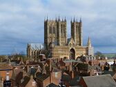
Lincolnshire has a rustic culture. Due to the large distances between the towns, many villages have remained very self-contained, with many still having shops, pubs, local halls and local chapels and churches, offering a variety of social activities for residents. Fishing (in the extensive river and drainage system in the fens) and shooting are popular activities. A lot of the culture in Lincoln itself is based upon its history. The Collection is an archaeological museum and art gallery in Lincoln. Lincoln Cathedral also plays a large part in Lincoln's culture, playing host to many events throughout the year, from concert recitals to indoor food markets.
A Lincolnshire tradition was that front doors were used for only three things: a new baby, a bride, and a coffin.[30]
مشاهير لنكنشاير
مشاهير الأشخاص المرتبطون بلنكنشاير، مثل:
- Guthlac of Crowland
- Hereward the Wake
- Little Saint Hugh of Lincoln
- Bishops of Lincoln Hugh of Lincoln and Robert Grosseteste
- إلينور من قشتالة
- Katherine Swynford
- الملك هنري الرابع من إنگلترة
- الملحن وليام بيرد
- كبير مستشاري الملكة إليزابث الأولى وليام سسيل، بارون أول بورگلي.
- العالم سير إسحق نيوتن
- Havelok the Dane
- مستكشف القطب الشمالي سير جون فرانكلن
- عالم النبات وجامع النباتاتجوسف بانكس
- الملاح ورسام الخرائط ماثيو فليندرز
- الجغرافي هالفورد ماكيندر
- مستكشف أسترالياجورج باس
- الرياضياتي جورج بول
- أحد الآباء المؤسسين للولايات المتحدة، توماس پين، الذي عُين ضابطاً في گرانثام في ديسمبر 1762.
- مخترع الكورنومتر جون هاريسون
- جامع التحف وليام ستوكلي
- الفنانون فرانك براملي وپيتر ده وينت
- الصحفي هربرت إنگرام
- الشعراء Alfred Lord Tennyson, Jean Ingelow, Anne Bradstreet and Elizabeth Jennings
- Bishop and founder of Corpus Christi College, Oxford, Richard Foxe
- الشهيدة الپروتستنتية أن أسكيو
- Founder of the Baptist denomination John Smyth (Baptist minister)
- Archbishop of Canterbury John Whitgift
- Translator on the Committee for The King James Bible Robert Tighe
- Author of "Foxe's Book of Martyrs" John Foxe
- Puritan Jootton
- مؤسس الحركة الميثودية جون وزلي وتشارلز وزلي
- Preacher Samuel Eyles Pierce
- عالم اللاهوت والكاتب الميثودي ريتشارد واطسون
- Bible commentator and co-founder of Church Missionary Society Thomas Scott (commentator)
- رئيس مستعمرة جيمستاون، ڤيرجينيا، والكاپتن جون سميث.
- الممثلات مادج كندال وسيبل ثورندايك
- A part of the Music Hall Act Old Mother Riley, Arthur Lucan
- Railway administrator Frank Pick
- "The Acid Bath Murderer" John George Haigh
- Businesswoman and Welsh language translator Lady Charlotte Guest
- Inventor of Crucible Steel Benjamin Huntsman
- Tenor Alfred Piccaver
- Field Marshal William Robertson
- Founder of "The Samaritans" Chad Varah
- Industrialists Joseph Ruston and William Tritton
- R.A.F personnel Douglas Bader, Leslie Manser, Frank Whittle, Guy Gibson
- Victoria Cross recipients Charles Richard Sharpe and Harold Jackson (VC)
- Founder of Royal College of Nursing Sarah Swift
- المؤرخ فرنسيس هيل
- رئيسة الوزراء السابقة مارگريت ثاتشر
. . . . . . . . . . . . . . . . . . . . . . . . . . . . . . . . . . . . . . . . . . . . . . . . . . . . . . . . . . . . . . . . . . . . . . . . . . . . . . . . . . . . . . . . . . . . . . . . . . . . . . . . . . . . . . . . . . . . . . . . . . . . . . . . . . . . . . . . . . . . . . . . . . . . . . . . . . . . . . . . . . . . . . . .
الرموز
انظر أيضاً
- Outline of England
- Custos Rotulorum of Lincolnshire – List of Keepers of the Rolls for Lincolnshire
- Earl of Lincoln is a title that has been created eight times in the Peerage of England and is currently represented.
- High Sheriff of Lincolnshire
- Lincolnshire (UK Parliament constituency) List of MPs for the Lincolnshire constituency
- Lincs Wind Farm
- Lists
- List of bridges and viaducts in Lincolnshire
- List of churches in Lincolnshire
- List of civil parishes in Lincolnshire
- List of companies in Lincolnshire – Both current and former
- List of forests and woodland in Lincolnshire
- List of monastic houses in Lincolnshire
- List of museums in Lincolnshire
- List of parliamentary constituencies in Lincolnshire
- List of places in Lincolnshire
- List of public art in Lincolnshire
- List of Roman sites in Lincolnshire
- List of schools in Lincolnshire
- List of watermills in Lincolnshire
- List of waterways in Lincolnshire
- List of windmills in Lincolnshire
- Lord Lieutenant of Lincolnshire
- Stamford Senior Youth Theatre
- 1185 East Midlands earthquake
المصادر
- ^ "Towns and cities, characteristics of built-up areas, England and Wales - Office for National Statistics". www.ons.gov.uk. Retrieved 2023-12-10.
- ^ Toby F. Martin, The Cruciform Brooch and Anglo-Saxon England, Boydell and Brewer Press (2015), pp. 174–178
- ^ Catherine Hills, The Anglo-Saxon migration to Britain: an archaeological perspective (2016)
- ^ Caitlin Green, The Origins of Louth: Archaeology and History in East Lincolnshire, 400,000 BC–AD 1086 (2014), pp. 66–67
- ^ "Lincolnshire County Council". Thebythams.org.uk. 24 October 2005. Archived from the original on 6 May 2009. Retrieved 29 June 2010.
- ^ "County Map Of Lincolnshire - Information About Lincolnshire". Visit North West. Archived from the original on 5 February 2022. Retrieved 5 February 2022.
- ^ "Famous". www.blanchflower.org. Archived from the original on 19 October 2021. Retrieved 5 February 2022.
- ^ "Tier limbo at Lincolnshire's northern border". The Lincolnite (in الإنجليزية). 31 December 2020. Archived from the original on 5 February 2022. Retrieved 5 February 2022.
- ^ Edward, Olivia. "The Lincolnshire Wolds - Geographical Magazine". geographical.co.uk (in الإنجليزية البريطانية). Archived from the original on 16 May 2022. Retrieved 5 February 2022.
- ^ "How many borders does Northamptonshire have? – SidmartinBio". www.sidmartinbio.org. Archived from the original on 5 February 2022. Retrieved 5 February 2022.
- ^ "Norfolk and Lincolnshire Border" (in English). 1 March 1865. Archived from the original on 5 February 2022. Retrieved 5 February 2022.
{{cite web}}: CS1 maint: unrecognized language (link) - ^ Bird, Dan (18 March 2018). "This map apparently shows where the north begins". LeicestershireLive (in الإنجليزية). Archived from the original on 5 February 2022. Retrieved 5 February 2022.
- ^ "BBC - Nottingham 360 - The Nottinghamshire border". www.bbc.co.uk. Archived from the original on 3 March 2018. Retrieved 5 February 2022.
- ^ says, Diane (13 February 2011). "Lincolnshire County". theBythams.org.uk. Archived from the original on 5 February 2022. Retrieved 5 February 2022.
- ^ "About the Isle of Axholme". axholme.info (in الإنجليزية). Archived from the original on 5 February 2022. Retrieved 5 February 2022.
- ^ "Lincolnshire Coast". www.ukcoastguide.co.uk. Archived from the original on 6 July 2022. Retrieved 5 February 2022.
- ^ "Lincolnshire Biodiversity Action Plan" (PDF). Archived from the original (PDF) on 18 June 2019. Retrieved 18 July 2019.
- ^ UKGE (3 December 2015). "A rare Cretaceous ichthyosaur from Lincolnshire". Deposits Magazine. Archived from the original on 29 November 2018. Retrieved 14 December 2018.
- ^ "The Lincoln Plesiosaur – The Collection". Thecollectionmuseum.com. Archived from the original on 29 November 2018. Retrieved 14 December 2018.
- ^ Franklin, Ashley (22 June 2017). "Man climbs Lincolnshire's highest point – but where is it?". lincolnshirelive.co.uk. Archived from the original on 22 April 2020. Retrieved 14 December 2018.
- ^ "Archived copy". Archived from the original on 7 August 2016. Retrieved 6 December 2018.
{{cite web}}: CS1 maint: archived copy as title (link) - ^ Sympson, E. Mansel (22 November 2012). Lincolnshire. Cambridge University Press. ISBN 9781107612648. Archived from the original on 16 March 2023. Retrieved 14 December 2018 – via Google Books.
- ^ "Conservationists and anglers clash over otters' return". Grantham Journal. 1 January 2018. Archived from the original on 3 December 2018. Retrieved 14 December 2018.
- ^ "Red kites at Belton House". National Trust. Archived from the original on 9 December 2018. Retrieved 14 December 2018.
- ^ "Wheat yield world record shattered in Lincolnshire". Farmers Weekly. 24 August 2015. Archived from the original on 7 December 2018. Retrieved 14 December 2018.
- ^ "New world record for combined peas set in Lincs – Agronomist & Arable Farmer". Aafarmer.co.uk. 30 August 2017. Archived from the original on 6 December 2018. Retrieved 14 December 2018.
- ^ "Potato Council Sutton Bridge Crop Storage Research (CSR) facility". Potato.org.uk. 12 September 2012. Archived from the original on 1 April 2013. Retrieved 2 April 2013.
- ^ "History of the Breed — National Lincoln Sheep Breeders Association". Lincolnsheep.com. Archived from the original on 6 December 2018. Retrieved 14 December 2018.
- ^ "Mobile Libraries". Lincolnshire County Council. Archived from the original on 11 November 2013. Retrieved 22 November 2013.
Wherever you live in Lincolnshire, whether in the countryside of the Wolds or Fens, the Coastal area or even on the edge of a town, a Mobile Library will stop nearby.
- ^ "Lincolnshire Sayings and Traditions". Rootsweb.ancestry.com. Archived from the original on 20 May 2013. Retrieved 2 April 2013.
- Foster, C. W.; Longley, Thomas, eds. (1924). The Lincolnshire Domesday and Lindsey Survey. Annual works of the society. Vol. 19. Horncastle: Lincoln Record Society.
