إل كاستيو، تشيتشن إيتسا
'إل كاستيو El Castillo (النطق الإسپاني: [el kas'tiʎo]), تعني بالإسبانية "القلعة")، ويعرف أيضا بإسم معبد كوكولكان، هو أحد أهرامات وسط أمريكا المدرجة التي تهيمن على وسط الموقع الأثري تشيتشن إيتسا في ولاية يوكاتان المكسيكية. المبني يسميه علماء الآثار رسميا تشيتشن إيتسا المنشأ 5B18.
| El Castillo | |
|---|---|
 المنظر الشمالي الغربي للهرم | |
| الاسم القديم | معبد كولكولكان |
| أنشئ | القرون 8-12 |
| النوع | هرم مدرج من وسط أمريكا UNESCO World Heritage Site 1988 (الجلسة رقم 12)[1] |
| المادة | حجر جيري |
| الارتفاع | 24 متر، بدون المعبد 30 متر، بالمعبد |
| القاعدة | 55.3 متر |
| الميل | 37°29'44" (الحواف) 47º19'50" (الجوانب) |
 | |
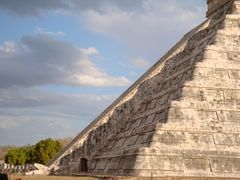
الهرم بنته حضارة المايا قبل كلومبس بين القرنين التاسع والثاني عشر الميلاديين، وقد خدم كمعبد للإله كوكولكان، الإله الثعبان الأزغب لمايا اليوكاتك، وثيق الصلة بالإله كوتزالكواتل المعروف للأزتك وحضارات وسط المكسيك الأخرى في الفترة بعد الكلاسيكية. يتكون الهرم من سلسلة من الشرفات المربعة ذات الأدراج التي تصعد كل من الجوانب الأربع حتى المعبد في القمة. منحوتات لثعابين مريشة تزحف هابطة على جوانب الدربزين الشمالي. أثناء الاعتدالين الربيعي و الخريفي، تغرب الشمس على الركن الشمالي الغربي الهرم وتلقي بسلسلة من الظلال المثلث على الدربزين الشمالي، تخلق إيحاء بثعبان مريش "يزحف" على الهرم. الحدث يحظى بشعبية هائلة، ولكن يبقى تساؤل حول ما إذا كان نتيجة تصميم ذي غرض.[2] كل من الجوانب الأربعة للهرب تتألف من 91 درجة، الذين إذا ما جمعوا معا وضمها مصطبة المعبد فوق الدرجة "الأخيرة"، كان حاصل الجمع هو 365 درجة (وهو ما يساوي عدد أيام سنة Haab').[3]
المنشأ ارتفاعه 24 متر، بالإضافة إلى المعبد. القاعدة المربعة يبلغ طول ضلعها 55.3 مترا.
. . . . . . . . . . . . . . . . . . . . . . . . . . . . . . . . . . . . . . . . . . . . . . . . . . . . . . . . . . . . . . . . . . . . . . . . . . . . . . . . . . . . . . . . . . . . . . . . . . . . . . . . . . . . . . . . . . . . . . . . . . . . . . . . . . . . . . . . . . . . . . . . . . . . . . . . . . . . . . . . . . . . . . . .
داخل الهرم
في 1566, the pyramid was described by Friar Diego de Landa in the manuscript known as Yucatán at the Time of the Spanish Encounter (Relación de las cosas de Yucatán). Almost three centuries later, John Lloyd Stephens described with even more detail the architecture of the pyramid in his book Incidents of Travel in Yucatán (Incidentes del viaje Yucatán), published in 1843. At that time, the archaeological site of تشيتشن إيتسا was located on an estate, also called تشيتشن إيتسا, owned by Juan Sosa. فردريك كاثروود illustrated the book with lithographs depicting the pyramid covered in abundant vegetation on all sides. There are some photographs taken in the beginning of the 20th century that also show the pyramid partially covered by said vegetation.
في 1924، طلبت مؤسسة كارنجي للعلوم في واشنطن العاصمة إذا من الحكومة المكسيكية للقيام باستكشافات وأعمال ترميم داخل وحول منطقة تشيتشن إيتسا. In 1927, with the assistance of Mexican archaeologists they started the task. In April 1931, looking to confirm the hypothesis that the structure of the pyramid of Kukulkan was built on top of a much older pyramid, the work of excavation and exploration began in spite of generalized beliefs contrary to that hypothesis. On June 7, 1932, a box with coral, obsidian, and turquoise encrusted objects was found alongside human remains, which are exhibited in the National Anthropology Museum in Mexico City.
After extensive work, in April 1935, a Chac Mool statue, with its nails, teeth, and eyes inlaid with mother of pearl was found inside the pyramid. The room where the discovery was made was nicknamed the hall of offerings or the north chamber. After more than a year of excavation, in August 1936, a second room was found, only meters away from the first. Inside this room, nicknamed the chamber of sacrifices, archaeologists found two parallel rows of human bone set into the back wall, as well as a red jaguar statue with 74 jade inlays for spots, jade crescents for eyes, and white painted flint for teeth and fangs. On its back was found a turquoise disc apparently used for burning incense. Both figures were found facing north-northeast. Researchers concluded that there must be an inner pyramid approximately 33 m (108 ft) wide, shaped similarly to the outer pyramid, with 9 steps and a height of 17 m (56 ft) up to the base of the temple where the Chac Mool and the jaguar were found. It is estimated that this construction dates to the eleventh century CE. After all of the work was completed, an entryway was cut into the balustrade of the northeastern exterior staircase to provide access to tourists. The older, inner pyramid is referred to as the "substructure".
- معرض الصور
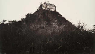
El Castillo before excavation, 1860
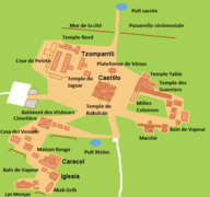
Situation map of El Castillo
North side of El Castillo
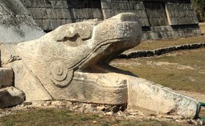
Plumed Serpent
Chichen Itza Equinox


آخر التطورات
In recent years, the National Institute of Anthropology and History (INAH), which manages the archaeological site of Chichen Itza, has been closing monuments to public. While visitors can walk around them, they can no longer climb them or go inside their chambers. Climbing El Castillo was stopped in 2006, after a woman fell to her death. At the same time INAH closed the public access to the interior throne room.[4]
Today "El Castillo" is one of the most recognized and widely visited pre-Columbian structures in present-day Mexico.[5]
Additionally, researchers have discovered an enormous cenote (also known as a sinkhole) beneath the 1,000-year-old temple of Kulkulkan. The forming sinkhole beneath the temple is around 82 by 114 feet (25 by 35 meters) and up to 65 feet (20 meters) deep. The water filling the cavern is thought to run from north to south.
Researchers also found a layer of limestone about 16 feet (4.9 meters) thick at the top of the cenote, on which the pyramid is sitting.
The discovery was made using new technology that involved placing electrodes in the area surrounding the structure, and delivering an electrical current to the ground. While the current was being emitted measurements were taken to determine whether there were sub-surface elements that impede or increased electrical potential. The measurements would then be processed by software, and three-dimensional maps of the underground area were created from the results.

انظر أيضاً
الهامش
المراجع
- Coe, Michael D. (1999). The Maya. Ancient peoples and places series (6th, fully revised and expanded ed.). London and New York: Thames & Hudson. ISBN 0-500-28066-5. OCLC 59432778.
- Milbrath, Susan (1999). Star Gods of the Maya: Astronomy in Art, Folklore, and Calendars. The Linda Schele series in Maya and pre-Columbian studies. Austin: University of Texas Press. ISBN 0-292-75225-3. OCLC 40848420.
- Šprajc, Ivan, and Pedro Francisco Sánchez Nava (2013). Astronomía en la arquitectura de Chichén Itzá: una reevaluación. Estudios de Cultura Maya XLI: p. 31–60.
- Willard, T.A. (1941). Kukulcan, the Bearded Conqueror : New Mayan Discoveries. Hollywood, CA: Murray and Gee. OCLC 3491500.
Gray, Richard. "Sacred Sinkhole Discovered 1,000-year-old-Mayan-Temple-Eventually-Destroy-Pyramid." Science & tech August 17, 2015. Dailymail. Web. August 17, 2015.
Justice, Adam. "Scientists discover sacred sinkhole cave under Chichen Itza pyramid." Science (2015). Ibtimes. Web. August 14, 2015.