كيزيكس
كيزيكس ( /ˈsɪzᵻkəs/؛ باليونانية قديمة: Κύζικος Kyzikos؛ تركية عثمانية: آیدینجق، Aydıncıḳ؛ إنگليزية: Cyzicus) كانت بلدة قديمة في ميسيا في الأناضول في محافظة بالق أسير في تركيا. It was located on the shoreward side of the present Kapıdağ Peninsula (the classical Arctonnesus), a tombolo which is said to have originally been an island in the Sea of Marmara only to be connected to the mainland in historic times either by artificial means or an earthquake.
Κύζικος (Greek) آیدینجق (Ottoman Turkish) | |
 Bas relief of a charioteer, late 6th century BC | |
 كما يظهر في تركيا | |
| المكان | Erdek, Balıkesir Province, Turkey |
|---|---|
| المنطقة | Mysia |
| الإحداثيات | 40°23′N 27°53′E / 40.38°N 27.89°ECoordinates: 40°23′N 27°53′E / 40.38°N 27.89°E |
| النوع | Settlement |
| التاريخ | |
| الباني | Pelasgian settlers |
| هـُـجـِر | القرن 11 الميلادي |
| الفترات | Archaic Greek to High Medieval |
| الثقافات | Greek, Ancient Roman, Byzantine |
| الأحداث | حصار كيزيكس |
موقع كيزيكس، الموجود على الطريق الواصل بين إردك و باندرمة، محمي من وزارة الثقافة التركية.
. . . . . . . . . . . . . . . . . . . . . . . . . . . . . . . . . . . . . . . . . . . . . . . . . . . . . . . . . . . . . . . . . . . . . . . . . . . . . . . . . . . . . . . . . . . . . . . . . . . . . . . . . . . . . . . . . . . . . . . . . . . . . . . . . . . . . . . . . . . . . . . . . . . . . . . . . . . . . . . . . . . . . . . .
التاريخ


The city was said to have been founded by Pelasgians from Thessaly, according to tradition at the coming of the Argonauts; later it received many colonies from Miletus, allegedly in 756 BC, but its importance began only after the Peloponnesian War, when the decay of Athens and Miletus set in. Alcibiades defeated the Lacedaemonians there (410 BC). Eudoxus of Cnidus had a school at Cyzicus and went with his pupils to Athens, visiting Plato, and then returned to Cyzicus, where he died 355 B.C.[2] The era of Olympiads in Cyzicus was reckoned from 135 or 139.
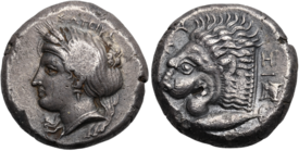
Owing to its advantageous position it speedily acquired commercial importance, and the gold staters of Cyzicus were a staple currency in the ancient world till they were superseded by those of Philip of Macedon. Its unique and characteristic coin, the cyzicenus, was worth 28 drachmae.
During the Peloponnesian War (431–404 BC) Cyzicus was subject to the Athenians and Lacedaemonians alternately. In the naval Battle of Cyzicus in 410 during the Peloponnesian War, an Athenian fleet routed and completely destroyed a Spartan fleet. At the peace of Antalcidas (387 BC), like the other Greek cities in Asia, it was made over to Persia. Alexander the Great later captured it from the Persians in 334 BC and was later claimed to be responsible for the land bridge connecting the island to the mainland.
The history of the town in Hellenistic times is closely connected with that of the Attalids of Pergamon, with whose extinction it came into direct relations with Rome. Cyzicus was held for the Romans against King Mithridates VI of Pontus who besieged it with 300,000 men in 74 BC, but it withstood him stoutly, and the siege was raised by Lucullus: the loyalty of the city was rewarded by an extension of territory and other privileges. The Romans favored it and recognized its municipal independence. Cyzicus was the leading city of Northern Mysia as far as Troas.

Under Tiberius, it was incorporated into the Roman Empire but remained the capital of Mysia (afterwards, Hellespontus) and became one of the great cities of the ancient world.
Cyzicus was captured temporarily by the Arabs led by Muawiyah I in AD 675. It appears to have been ruined by a series of earthquakes beginning in 443, with the last in 1063. Although its population was transferred to Artake before the 13th century when the peninsula was occupied by the Crusaders, in 1324 the metropolitan of Cyzicus was one of three sees in Anatolia which was able to contribute a temporary annual subsidy to the Patriarchate of Constantinople. Following its conquest by the Ottomans it underwent hard times. From a point between 1370 and 1372 until 1387, the metropolitan was empty; Speros Vryonis speculates this was due to financial difficulties. Later in the 14th century, the sees of Chalcedon and certain patriarchal possessions in Bithynia and Hellespont were bestowed on the metropolitan of Cyzicus.[3]
في العصر العثماني، كانت جزءاً من قضاء إردك في ولاية بروسة.
التاريخ الكنسي
Cyzicus, as capital of the Roman province of Hellespontus, was its ecclesiastical metropolitan see.
التماثيل
The site amid the marshes of Balkiz Serai is known as Bal-Kiz and entirely uninhabited, though under cultivation. The principal extant ruins are the walls, dating from the fourth century, which are traceable for nearly their whole extent, and the substructures of the temple of Hadrian, the ruins of a Roman aqueduct and a theatre.
The picturesque amphitheatre, intersected by a stream, was one of the largest in the world. Construction for the amphitheatre began in the middle of the first century C.E until the end of the third century C.E. Its diameter was nearly 500 feet (150 m) and it is located specifically at these coordinates 27°53′04″N 40°23′54″E / 27.884552°N 40.398213°E within the region of Cyzicus. Of this magnificent building, sometimes ranked among the seven wonders of the ancient world, thirty-one immense columns still stood erect in 1444. These have since been carried away piecemeal for building purposes.
Colossal foundations of a temple dedicated to the Emperor Hadrian are still visible: the columns were 21.35 metres high (about 70 feet), while the highest known elsewhere, those at Baalbek in Syria are only 19.35 metres (about 63 feet).
The monuments of Cyzicus were used by the Byzantine emperor Justinian as a quarry for the building of his Saint Sophia cathedral, and were still exploited by the Ottomans.
أشخاص بارزون
- Androsthenes of Cyzicus, 200 BC, accompanied King Antiochus III the Great to India.
- Eudoxus of Cyzicus, 130 BC, navigator and explorer.
- Proclus of Constantinople, appointed metropolitan of Cyzicus in 5th century but never functioned as such; patriarch of Constantinople and important figure in the development of Christology
- Germanus of Constantinople, early eighth century metropolitan of Cyzicus and later Patriarch of Constantinople and early iconophile theologian
- Gelasius of Cyzicus, 5th century ecclesiastical writer.
- Adrastus of Cyzicus, a mathematician cited by Augustine of Hippo
- Theophanes the Confessor, who began his formal religious life at the Polychronius Monastery, located near Cyzicus.
- Lala, a female painter and sculptor, known as Lala from Cyzicus.
المراجع
- ^ Leo Mildenberg, "The Cyzicenes, a Reappraisal", American Journal of Numismatics, Vol. 5/6 (1993-94), pp. 1-12.
- ^ Florian Cajori, A History of Mathematics (1893)
- ^ Vryonis, The Decline of Medieval Hellenism in Asia Minor and the Process of Islamization from the Eleventh through the Fifteenth Century (Berkeley: University of California, 1971), pp. 299f
المصادر
- This article incorporates text from a publication now in the public domain: Chisholm, Hugh, ed. (1911). . دائرة المعارف البريطانية (eleventh ed.). Cambridge University Press.
{{cite encyclopedia}}: Cite has empty unknown parameter:|coauthors=(help)  هذه المقالة تضم نصاً من مطبوعة هي الآن مشاع: هربرمان, تشارلز, ed. (1913). . الموسوعة الكاثوليكية. Robert Appleton Company.
 {{cite encyclopedia}}: Cite has empty unknown parameters:|1=,|coauthors=, and|month=(help); Invalid|ref=harv(help)- Trapp, Erich; Beyer, Hans-Veit (2001). Prosopographisches Lexikon der Palaiologenzeit (in German). Vol. I, 1–12, Add. 1–2, CD-ROM Version. Vienna: Verlag der Österreichischen Akademie der Wissenschaften. ISBN 978-3-7001-3003-1.
{{cite encyclopedia}}: Missing or empty|title=(help)CS1 maint: unrecognized language (link)