پاتنا
| ||||||||||||||||||||||||||||||||||||||||||||||||||||||||||||||||||||||||||||||||||||||||||||||||
| ||||||||||||||||||||||||||||||||||||||||||||||||||||||||||||||||||||||||||||||||||||||||||||||||


Patna /ˈpʌtnaː/ is the capital and largest city of the state of Bihar in India. Patna is the second largest city in eastern India after Kolkata. It had an estimated population of 1.68 million in 2011, making it the 19th largest city in India. With over 2 million people, its urban agglomeration is the 18th largest in India. Patna also serves as the seat of Patna High Court.
One of the oldest continuously inhabited places in the world.[7] Patna was founded in 490 BCE by the king of Magadha. Ancient Patna, known as Pataliputra, was the capital of the Magadha Empire under the Haryanka, Nanda, Mauryan, Shunga, Gupta and Pala empires. Pataliputra was a seat of learning and fine arts. Its population during the Maurya period (around 300 BCE) was about 400,000.[8]
The modern city of Patna is situated on the southern bank of river Ganges.[9] The city also straddles the rivers Sone, Gandak and Punpun. The city is approximately 35 kilometres (22 mi) in length and 16 to 18 kilometres (9.9 to 11.2 mi) wide. In June 2009, the World Bank ranked Patna second in India (after Delhi) for ease of starting a business.[10] As of 2011-12, Patna had the highest per capita gross district domestic product in Bihar, at ₹63,063.[11][12] Using figures for assumed average annual growth, Patna is the 21st fastest growing city in the world and 5th fastest growing city in India according to a study by the City Mayors' Foundation. Patna registered an average annual growth of 3.72% during 2006-2010.[13]
The Buddhist, Hindu, and Jain pilgrimage centres of Vaishali, Rajgir, Nalanda, Bodh Gaya, and Pawapuri are nearby and Patna City is also a sacred city for Sikhs as the tenth Sikh Guru, Guru Gobind Singh, was born here.[14]
. . . . . . . . . . . . . . . . . . . . . . . . . . . . . . . . . . . . . . . . . . . . . . . . . . . . . . . . . . . . . . . . . . . . . . . . . . . . . . . . . . . . . . . . . . . . . . . . . . . . . . . . . . . . . . . . . . . . . . . . . . . . . . . . . . . . . . . . . . . . . . . . . . . . . . . . . . . . . . . . . . . . . . . .
التاريخ
الامبراطورية الماورية

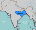
Pataliputra as a capital of the Magadha Empire.
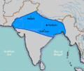
Pataliputra as a capital of Nanda Empire.
The Nanda Empire at its greatest extent under Dhana Nanda (c. 323 BCE).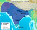
Pataliputra as a capital of Maurya Empire.
The Maurya Empire at its largest extent under Ashoka the Great.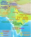
Pataliputra as a capital of Shunga Empire.
Approximate greatest extent of the Shunga Empire (c. 185 BCE).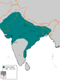
Pataliputra as a capital of Gupta Empire.
Approximate greatest extent of the Gupta Empire.


امبراطوريتا گوپتا والمغل


الامبراطورية البريطانية

حركة الاستقلال الهندية
الجغرافيا
الطبوغرافيا

| الدائرة | التعداد | |||||
|---|---|---|---|---|---|---|
| البلدة | النوع | تقدير (2011) | ||||
| پاتنا' | Municipal Corportation | 1,684,222 | ||||
| Dinapur Nizamat | Nagar Parishad | 182,429 | ||||
| Badalpura | Out Growth | 75 | ||||
| Dinapur Cantonment | Cantonment Board | 28,723 | ||||
| Khagaul | Nagar Parishad | 44,364 | ||||
| Nohsa | Census Town | 16,680 | ||||
| Pataliputra Housing Colony | Census Town | 3,531 | ||||
| Phulwari Sharif | Nagar Parishad | 81,740 | ||||
| Saidpura | Census Town | 7,392 | ||||
| Patna UA | 2,049,156 | |||||
| Patna district | 5,838,465 | |||||
| Source:[15][16] | ||||||
المناخ
| Patna | ||||||||||||||||||||||||||||||||||||||||||||||||||||||||||||
|---|---|---|---|---|---|---|---|---|---|---|---|---|---|---|---|---|---|---|---|---|---|---|---|---|---|---|---|---|---|---|---|---|---|---|---|---|---|---|---|---|---|---|---|---|---|---|---|---|---|---|---|---|---|---|---|---|---|---|---|---|
| جدول طقس (التفسير) | ||||||||||||||||||||||||||||||||||||||||||||||||||||||||||||
| ||||||||||||||||||||||||||||||||||||||||||||||||||||||||||||
| ||||||||||||||||||||||||||||||||||||||||||||||||||||||||||||
| بيانات مناخ Patna | |||||||||||||
|---|---|---|---|---|---|---|---|---|---|---|---|---|---|
| الشهر | يناير | فبراير | مارس | أبريل | مايو | يونيو | يوليو | أغسطس | سبتمبر | اكتوبر | نوفمبر | ديسمبر | العام |
| العظمى القياسية °س (°ف) | 30.0 (86) |
35.1 (95.2) |
41.4 (106.5) |
44.6 (112.3) |
45.6 (114.1) |
46.6 (115.9) |
41.2 (106.2) |
39.7 (103.5) |
37.5 (99.5) |
37.2 (99) |
34.1 (93.4) |
30.5 (86.9) |
46٫6 (115٫9) |
| العظمى المتوسطة °س (°ف) | 23 (73) |
26.1 (79) |
32.4 (90.3) |
37.4 (99.3) |
38.4 (101.1) |
36.7 (98.1) |
32.9 (91.2) |
32.5 (90.5) |
32.2 (90) |
31.7 (89.1) |
28.9 (84) |
24.6 (76.3) |
31٫4 (88٫5) |
| المتوسط اليومي °س (°ف) | 16.2 (61.2) |
18.9 (66) |
24.4 (75.9) |
29.8 (85.6) |
31.8 (89.2) |
31.7 (89.1) |
29.5 (85.1) |
29.3 (84.7) |
28.8 (83.8) |
26.7 (80.1) |
21.9 (71.4) |
19.7 (67.5) |
25٫3 (77٫5) |
| الصغرى المتوسطة °س (°ف) | 9.3 (48.7) |
11.6 (52.9) |
16.4 (61.5) |
22.1 (71.8) |
25.1 (77.2) |
26.7 (80.1) |
26.1 (79) |
26.1 (79) |
25.3 (77.5) |
21.6 (70.9) |
14.8 (58.6) |
10.1 (50.2) |
19٫6 (67٫28) |
| الصغرى القياسية °س (°ف) | 1.1 (34) |
3.4 (38.1) |
8.2 (46.8) |
13.3 (55.9) |
17.7 (63.9) |
19.3 (66.7) |
21.1 (70) |
20.5 (68.9) |
19.0 (66.2) |
12.0 (53.6) |
7.7 (45.9) |
2.2 (36) |
1٫1 (34) |
| هطول mm (inches) | 15.2 (0.598) |
11.1 (0.437) |
11.4 (0.449) |
9 (0.35) |
35.6 (1.402) |
133.5 (5.256) |
302.4 (11.906) |
266.3 (10.484) |
194.7 (7.665) |
24.6 (0.969) |
8.2 (0.323) |
7.4 (0.291) |
1٬019٫4 (40٫134) |
| سقوط الأمطار mm (inches) | 12.2 (0.48) |
14.1 (0.555) |
09.4 (0.37) |
10.8 (0.425) |
38.1 (1.5) |
142.5 (5.61) |
381.0 (15) |
281.6 (11.087) |
229.3 (9.028) |
78.6 (3.094) |
8.7 (0.343) |
7.0 (0.276) |
1٬213٫3 (47٫768) |
| Avg. rainy days | 1.3 | 1.2 | 0.7 | 1.0 | 2.7 | 6.5 | 14.9 | 12.8 | 10.2 | 3.3 | 0.6 | 0.7 | 55٫9 |
| Source #1: India Meteorological Department (Period 1901–2000, record high and low up to 2010)[19][20] (rainfall 1971-2000[21] | |||||||||||||
| Source #2: worldweather.org[22] | |||||||||||||
. . . . . . . . . . . . . . . . . . . . . . . . . . . . . . . . . . . . . . . . . . . . . . . . . . . . . . . . . . . . . . . . . . . . . . . . . . . . . . . . . . . . . . . . . . . . . . . . . . . . . . . . . . . . . . . . . . . . . . . . . . . . . . . . . . . . . . . . . . . . . . . . . . . . . . . . . . . . . . . . . . . . . . . .
الاقتصاد

السكان
| Year | Pop. | ±% |
|---|---|---|
| 1807-14 | 312٬000 | — |
| 1820 | 100٬000 | −67.9% |
| 1865 | 284٬100 | +184.1% |
| 1872 | 158٬000 | −44.4% |
| 1881 | 170٬684 | +8.0% |
| 1891 | 165٬200 | −3.2% |
| 1901 | 134٬785 | −18.4% |
| 1911 | 136٬153 | +1.0% |
| 1921 | 119٬976 | −11.9% |
| 1931 | 159٬690 | +33.1% |
| 1941 | 196٬415 | +23.0% |
| 1951 | 283٬479 | +44.3% |
| 1961 | 364٬594 | +28.6% |
| 1971 | 475٬300 | +30.4% |
| 1981 | 813٬963 | +71.3% |
| 1991 | 1٬099٬647 | +35.1% |
| 2001 | 1٬376٬950 | +25.2% |
| 2011 | 1٬683٬200 | +22.2% |
| ملاحظة: Huge population decline after 1814 due to the decrease in the river borne trade, persistent unhealthiness and repeated epidemics of plaque. Source: [23][24][25] | ||
 Maurya Lok is one of the oldest and major shopping area of the city |
 Mahavir Mandir, most famous temple in Patna |
النقل


السياحة


ملاحظات
- ^ Master plan for Patna (2031), awaits Cabinet's approval.[2] The draft master plan for Patna metropolitan area proposes that Patna Metropolitan Region would incorporate Bihta, Danapur, Khagaul, Daniyawan, Danaura, Fatuha, Khusrupur, Maner, Masaurhi, Naubatpur, Phulwari Sharif, Punpun and Sampatchak blocks of Patna district, areas of Vaishali and Saran districts are excluded.[3]
الهامش
- ^ "CDP Patna" (PDF). Infrastructure Professionals Enterprise (P) Ltd, C - 2, Green Park Extension, New Delhi – 110016, INDIA. PATNA — Urban Development Department. July 2006. pp. 20, 21 (area) 52 (metropolis), 31 (geography). Retrieved 13 April 2014.
- ^ "Home still a dream sans nod to map in Patna". Economics Times. 15 May 2015. Retrieved 21 June 2015.
- ^ "Master Plan for Patna, 2031" (PDF). Center for Environmental Planning and Technology. Urban Development & Housing Department, Govt. of Bihar. 13 August 2015. Retrieved 21 June 2015.
- ^ "CPRS Patna About Us". CRPS. Retrieved 1 June 2014.
- ^ أ ب "Provisional Population Totals, Census of India 2011; Urban Agglomerations/Cities having population 1 lac and above" (PDF). Office of the Registrar General & Census Commissioner, India. Retrieved 26 March 2012.
- ^ "About District". Patna.bih.nic.in. 2004-01-01. Retrieved 2013-12-04.
- ^ "Populations of Largest Cities in PMNs from 2000BC to 1988AD". Archived from the original on 22 August 2008.
{{cite web}}:|archive-date=/|archive-url=timestamp mismatch; 29 سبتمبر 2007 suggested (help) - ^ O'Malley, L. S. S. (2005). James, J. F. W. (ed.). History of Magadha. Delhi: Veena Publication. p. 23. ISBN 978-81-89224-01-1. Retrieved 24 February 2011.
- ^ "Patna : the capital of Bihar State, Patna District". Brandbharat.com. Retrieved 2013-12-04.
- ^ "New Delhi, Patna best cities to start business: World Bank". The Times of India. The Times of India. PTI. 30 June 2009. Retrieved 24 February 2011.
- ^ "आर्थिक सर्वेक्षण: पटना के लोगों की कमाई में 9 प्रतिशत का इजाफा". Dainik Bhaskar. 12 March 2015. Retrieved 12 March 2015.
- ^ "Patna dist records highest per capita GDDP in state — The Times of India". Timesofindia.indiatimes.com. 2014-01-21. Retrieved 2014-04-11.
- ^ "Fastest growing cities and urban areas (1 to 100)". Citymayors.com. Retrieved 4 March 2012.
- ^ "Gurdwara-gears-up-for-Guru's-jayanti,Kumod Verma, TNN, 30 December 2001". Articles.timesofindia.indiatimes.com. 30 December 2001. Retrieved 4 March 2012.
- ^ "Patna Urban Region". Census2011.co.in. Retrieved 7 December 2015.
- ^ "Patna District : Census 2011 data". Census2011.co.in. Retrieved 8 December 2015.
- ^ India Meteorological Department 8 May 2015
- ^ wetterkontor.de 8 May 2015
- ^ "Monthly mean maximum & minimum temperature and total rainfall based upon 1901-2000 data:" (PDF). imd.gov.in. Retrieved 18 February 2015.
- ^ "Extremes for Delhi" (PDF). Indian Meteorological Department. Retrieved January 21, 2015.
- ^ "CLIMATOLOGICAL TABLE PERIOD: 1971-2000". imd.gov.in. Retrieved 18 February 2015.
- ^ "Climatological Information for Patna". World Weather. Retrieved 31 July 2013.
- ^ Television and Development of Women By Preeti Kumari Google Book
- ^ "India-historical demographical data of the urban centers". populstat. Retrieved 8 December 2015.
- ^ "Census of India 2001 (Provisional) Slum Population in Million Plus Cities (Municipal Corporations): Part A". Office of the Registrar General & Census Commissioner, India, New Delhi. Retrieved 8 December 2015.
- ^ خطأ استشهاد: وسم
<ref>غير صحيح؛ لا نص تم توفيره للمراجع المسماةcensus2011
للاستزادة
- Lewis Sydney Steward O'Malley, ed. (1924). Bihar And Orissa District Gazetteers Patna. Concept Publishing Company. p. 256. ISBN 9788172681210.
- Surendra Gopal, ed. (1982). Patna in the 19th Century: A Socio-cultural Profile. Naya Prokash. p. 120.
- Robert Montgomery Martin, ed. (1838). Behar (Patna city) and Shahabad, Volume 1 of The History, Antiquities, Topography, and Statistics of Eastern India. W. H. Allen and Co. p. 256.
- William Tayler, ed. (1858). The Patna crisis; or, Three months at Patna: during the insurrection of 1857. J. Nisbet. p. 96.
- J. D. Beglar, Sir Alexander Cunningham, ed. (1878). Report of a Tour Through the Bengal Provinces of Patna, Gaya, Mongir, and Bhagalpur: The Santal Parganas, Manbhum, Singhbhum, and Birbhum ; Bankura, Raniganj, Bardwan, and Hughli : in 1872-73 Volume 8 of Archaeological Survey of India. Office of the Superintendent of Government Printing. p. 213.
- Walter Kelly Firminger, ed. (1909). The Diaries of Three Surgeons of Patna - 1763. The Calcutta Historical Society.
. . . . . . . . . . . . . . . . . . . . . . . . . . . . . . . . . . . . . . . . . . . . . . . . . . . . . . . . . . . . . . . . . . . . . . . . . . . . . . . . . . . . . . . . . . . . . . . . . . . . . . . . . . . . . . . . . . . . . . . . . . . . . . . . . . . . . . . . . . . . . . . . . . . . . . . . . . . . . . . . . . . . . . . .
وصلات خارجية
| Find more about پاتنا at Wikipedia's sister projects | |
| Definitions from Wiktionary | |
| Media from Commons | |
| Quotations from Wikiquote | |
| Source texts from Wikisource | |
| Textbooks from Wikibooks | |
| Learning resources from Wikiversity | |
- Official website of Patna district
- Official website of the Municipal Corporation of Patna
 پاتنا travel guide from Wikivoyage