منطقة تل أبيب العمرانية
منطقة تل أبيب العمرانية[3] (بالعبرية: מֶטְרוֹפּוֹלִין תֵּל אָבִיב؛ إنگليزية: Tel Aviv Metropolitan Area)، أو گوش دان (بالعبرية: גּוּשׁ דָּן) هي منطقة عمرانية ("المتروبوليتان") تضم مساحات من كل من منطقتي تل أبيب المركزية في إسرائيل. تطل المنطقة علي ساحل البحر المتوسط، وتضم كامل منطقة تل أبيب وما جاورها من مدن ومناطق. وتعد أكبر منطقة عمرانية (متروبوليتان) في إسرائيل، بعدد سكان يزيد عن 3 ملايين نسمة.
منطقة تل أبيب العمرانية
גוש דן | |
|---|---|
 | |
| الكنية: Dan Bloc (Gush Dan in Hebrew) | |
 | |
| الإحداثيات: 32°2′N 34°46′E / 32.033°N 34.767°ECoordinates: 32°2′N 34°46′E / 32.033°N 34.767°E | |
| Country | |
| Metropolitan Area | گوش دان |
| المساحة | |
| • منطقة عمرانية | 1٬516 كم² (585 ميل²) |
| التعداد | |
| • العمرانية | 3٬210٬000٫ 42٫1% of Israel's Population |
| • الكثافة العمرانية | 2٬115/km2 (5٬480/sq mi) |
| الديمغرافيا: اليهود الإسرائيليون 94.9%, عرب إسرائيل 5.1%. | |
| منطقة التوقيت | UTC+2 (IST) |
| • الصيف (التوقيت الصيفي) | UTC+3 (IDT) |
| Postal code | 61999 |
| Area code | +972 (Israel) 3 (City) |
| الموقع الإلكتروني | tel-aviv.gov.il |
. . . . . . . . . . . . . . . . . . . . . . . . . . . . . . . . . . . . . . . . . . . . . . . . . . . . . . . . . . . . . . . . . . . . . . . . . . . . . . . . . . . . . . . . . . . . . . . . . . . . . . . . . . . . . . . . . . . . . . . . . . . . . . . . . . . . . . . . . . . . . . . . . . . . . . . . . . . . . . . . . . . . . . . .
التاريخ
| التعداد التاريخي | ||
|---|---|---|
| السنة | تعداد | ±% |
| 1946 | 343٬000 | — |
| 1956 | 845٬000 | +146.4% |
| 1966 | 1٬291٬000 | +52.8% |
| 1976 | 1٬661٬000 | +28.7% |
| 1986 | 2٬036٬000 | +22.6% |
| 1996 | 2٬547٬000 | +25.1% |
| 2006 | 3٬098٬000 | +21.6% |
| 2016 | 3٬854٬000 | +24.4% |
| المصدر: [4][5][6] | ||
The name Gush Dan means "Dan Bloc", and is so named because the area was the territory of the tribe of Dan in the ancient Kingdom of Israel. According to the biblical narrative, the tribe had originally tried to settle in the central coastal area of Canaan, but enmity with the Philistines, who had already settled there, caused it to be able to camp only in the hill country overlooking the Sorek Valley. The camp location became known as Mahaneh Dan ("Camps of Dan"). The region that they attempted to settle included the area as far north as Joppa and as far south as Shephelah in the area of Timnah. As a result of the pressure from the Philistines, the tribe abandoned hopes of settling near the central coast and instead migrated to the north of the country. After conquering Laish, the tribe refounded it as its capital and renamed it Dan. In remembrance of the original territory assignments, the coastal region is referred to as Gush Dan. The modern city of Tel Aviv was founded in 1909 as a suburb of the Arab-majority coastal city of Jaffa.[8]
The city grew rapidly in the ensuing decades by Jewish immigration from Europe, with its population reaching 150,000 in 1934, and 230,000 when Israel gained its independence 1948. Before the establishment of Israel, other towns in the Gush Dan were founded as well, such as Petah Tikva in 1878, Rishon LeZion in 1882, Ness Ziona in 1883, Rehovot in 1890, and most other Gush Dan cities were established before 1948.
In 1947, the Jewish population of the Gush Dan was nearly 400,000 and was the majority of the Jewish population of Mandate Palestine. As such, almost all of it was included in the Jewish state proposed by the 1947 United Nations Partition Plan for Palestine. After the 1948 Arab–Israeli War, the Arab population of the region, which had been nearly 150,000 before the war,[8] was reduced to around 10,000. They were quickly replaced by a larger number of Jews fleeing from postwar Europe and persecution in Arab countries.
However, many new immigrants did not then come to Tel Aviv. In the 1950s, towns were built on the edges of the Gush Dan, including Ashdod, Rosh HaAyin and Yavne. The nation's sole port was then located in the northern city of Haifa and its evolving metropolitan area, making that city at least as important as Tel Aviv. The new government was then trying to disperse the nation's population to the periphery and discouraged settlement in the already-populated Gush Dan. That slowed the growth of the Gush Dan, but the area still more than doubled in population within 20 years of the establishment of Israel. The opening of the Port of Ashdod in the southern Gush Dan also increased the area's importance, with the importance of Haifa diminishing and that of Tel Aviv increasing because of its proximity to the Port of Ashdod. Tel Aviv itself witnessed population decreases in the 1970s and 1980s, when outer regions of the Gush Dan with lower costs of living absorbed many of the people who had left Tel Aviv.
Only in the 1990s, with the immigration of more than 1 million Jews from former Soviet Republics, 40,000 Ethiopian Jews, and many others to Israel, as well as a boom in the religious population, would Tel Aviv begin to grow again. The demand for housing increased dramatically, with new cities such as Modiin and El'ad being built, and cities like Ashdod more than doubling in population, from 83,000 in 1990, to 175,000 in 2000. In the 2000s, the area continued to grow, attracting many immigrants from the Haifa metropolitan area. With a population of 4,052,200 people as of 2019,[9] Gush Dan is home to the commercial, economical, cultural, and industrial center of Israel.
Despite some successes in ongoing attempts by the Israeli government to encourage migration to the Galilee and the Negev, Gush Dan retains its position as the heart of Israel.
المدن في گوش دان
Population in cities as of the end of 2021:[10]
- فوق 400,000
- تل أبيب-يافا 460,613
- فوق 200,000
- ريشون لتصيون 254,384
- پتاح تكڤا 247,956
- أشدود 225,939
- نتانيا 221,353
- بني براك 204,639
- فوق 100,000
- حولون 196,282
- رمات گان 163,480
- عسقلان 144,073
- رحوڤوت 143,904
- بات يام 129,013
- هرتسليا 97,470
- كفار سابا 101,432
- فوق 50,000
- Modi'in-Maccabim-Re'ut 93,277
- اللد 77,223
- رعنانا 75,421
- الرملة 76,246
- Rosh HaAyin 61,801
- Hod HaSharon 63,175
- Givatayim 60,644
- Yavne 47,585
- Ness Ziona 50,351
- فوق 20,000
- El'ad 48,763
- Ramat HaSharon 47,245
- Tayibe 43,957
- Kiryat Ono 40,409
- Yehud-Monosson 29,928
- Gedera 28,313
- Be'er Ya'akov 27,768
- Giv'at Shmuel 26,578
- Kfar Yona 24,778
- Tira 26,552
- Kafr Qasim 23,823
- Gan Yavne 23,869
- Qalansawe 23,143
- Kadima-Zoran 22,683
- Ganei Tikva 20,398
- Shoham 21,045
- فوق 10,000
- Mazkeret Batya 14,837
- Even Yehuda 13,826
- Tel Mond 13,144
- Kiryat Ekron 11,001
- جلجولية 10,148
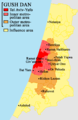
Map of the Gush Dan
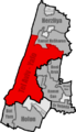
Map of inner metropolitan area
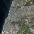
Satellite Image of the Inner Ring of the Gush Dan
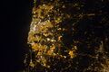
NASA photo of Tel Aviv area at night


.jpg&filetimestamp=20231010135658&)
الحلقات العمرانية
مكتب الإحصاء المركزي الإسرائيلي يقسم منطقة تل أبيب العمرانية إلى أربع مناطق:
| حلقة عمرانية | المحليات | التعداد (تعداد 2009) | الكثافة السكانية (/كم²) |
معدل النمو السنوي للتعداد | |||
|---|---|---|---|---|---|---|---|
| الإجمالي | اليهود وغيرهم1 | ومنهم: اليهود | العرب | ||||
| Core2 | 1 | 392,500 | 375,100 | 358,600 | 17,300 | 7,576.6 | 0.6% |
| الحلقة الداخلية3 | 13 | 834,600 | 833,600 | 787,900 | 1,000 | 6,931.7 | 1.0% |
| القسم الشمالي | 4 | 125,100 | 125,000 | 121,500 | 100 | 2,936.9 | 1.0% |
| القسم الشرقي | 5 | 398,800 | 398,600 | 388,100 | 200 | 9,921.1 | 1.3% |
| القسم الجنوبي | 4 | 310,600 | 310,000 | 278,300 | 700 | 8,261.5 | 0.5% |
| الحلقة الوسطى4 | 31 | 1,004,400 | 971,400 | 923,300 | 33,000 | 3,452.6 | 1.7% |
| القسم الشمالي | 6 | 205,200 | 205,000 | 199,400 | 200 | 3,922.9 | 1.3% |
| القسم الشرقي | 8 | 258,500 | 258,400 | 243,000 | 100 | 3,790.0 | 2.5% |
| القسم الجنوبي | 17 | 540,700 | 508,000 | 480,800 | 32,700 | 3,175.0 | 1.5% |
| الحلقة الخارجية5 | 206 | 975,100 | 863,400 | 826,400 | 111,600 | 929.0 | 2.6% |
| القسم الشمالي | 95 | 406,300 | 324,600 | 311,200 | 81,600 | 1,051.2 | 2.2% |
| القسم الشرقي | 47 | 225,400 | 195,800 | 193,900 | 29,600 | 802.0 | 3.9% |
| القسم الجنوبي | 64 | 343,300 | 343,000 | 321,300 | 400 | 898.8 | 2.2% |
| الإجمالي | 251 | 3,206,400 | 3,043,500 | 2,896,200 | 163,000 | 2,119.7 | 1.7% |
ملاحظات
- 1 تعداد "اليهود وغيرهم" يضم اليهود الإسرائيليون، المسيحيون غير العرب وأولئك غير المصنفين حسب الدين.
- 2 The core area includes the city of Tel Aviv.
- 3 The inner ring includes the cities Bat Yam, Holon, Ramat HaSharon, رمات گان, Giv'atayim, Bnei Brak, هرتسليا, Or Yehuda, Giv'at Shmuel and Kiryat Ono, as well as a multitude of smaller towns (local councils).
- 4 الحلقة الوسطى تضم مدن پتاح تكڤا، Ra'anana, ريشون لتسيون, Hod HaSharon, كفار سابا، Yehud، الرملة, اللد, Rosh HaAyin, Ness Ziona and Rehovot, as well as many smaller towns (local councils).
- 5 The outer ring includes the cities Tayibe, نتانيا, Modi'in-Maccabim-Re'ut, أشدود, as well as many smaller towns (local councils).
مناظر پانوراما


انظر أيضا
مراجع
- ^ "לוח 3.- אוכלוסייה( 1), ביישובים שמנו מעל 2,000 תושבים( 2) ושאר אוכלוסייה כפרית POPULATION(1) OF LOCALITIES NUMBERING ABOVE 2,000 RESIDENTS(2) AND OTHER RURAL POPULATION" (PDF). Retrieved 2010-01-25.
{{cite journal}}: Cite journal requires|journal=(help) - ^ http://www.cbs.gov.il/shnaton60/st02_16.pdf
- ^ أ ب "Localities, Population, and Density" (PDF). Retrieved 2010-01-24.
- ^ "Population of Israel on the Eve of 2018 - 8.8 Million". Press Release. Israel Central Bureau of Statistics. 31 December 2017. Retrieved 2 January 2018.
- ^ "Population, by Population Group". Statistical Abstract of Israel. Israel Central Bureau of Statistics. 11 September 2012. Retrieved 5 April 2013.
- ^ "Monthly Bulletin of Statistics for Population". Israel Central Bureau of Statistics. 7 August 2013. Retrieved 24 August 2013.
- ^ http://www.cbs.gov.il/ts/ID98991f858e0e0c/[dead link]
- ^ أ ب "Tel Aviv-Yafo-Statistical Overview". Archived from the original on 2014-09-13. Retrieved 2016-02-06.
- ^ https://www.cbs.gov.il/he/mediarelease/DocLib/2014/199/24_14_199map3.pdf[bare URL PDF]
- ^ "Population in the Localities 2019" (XLS). Israel Central Bureau of Statistics. Retrieved 16 August 2020.