مناخ أستراليا
مناخ أستراليا يحكمه في الغالب حجم القارة والهواء الساخن الغاطس من حزام الضغط العالي شبه المداري (الامتداد شبه المداري). ويتحرك هذا الحزام إلى الشمال الغربي والشمال الشرقي حسب الموسم. المناخ متغير ، مع فترات جفاف متكررة تستمر عدة مواسم ، ويُعتقد أن سببها جزئيًا إل نينيو - التأرجح الجنوبي. تتمتع أستراليا بمجموعة متنوعة من المناخات نظرًا لحجمها الجغرافي الكبير. الجزء الأكبر من أستراليا هو صحراء أو شبه قاحل. تتمتع الزوايا الجنوبية الشرقية والجنوبية الغربية فقط مناخ معتدل باعتدال تربة خصبة. الجزء الشمالي من البلاد له مناخ استوائي ، يتفاوت بين الأراضي العشبية والصحراء. تمتلك أستراليا العديد من السجلات المتعلقة بالحرارة: تمتلك القارة أكثر المناطق سخونة على مدار العام ، والمناطق ذات المناخ الصيفي الأكثر سخونة، وأعلى مدة لسطوع الشمس.

نظراً لأن أستراليا قارة متوسطة الحجم، يفصلها عن المناطق القطبية المحيط الجنوبي، فهي لا تخضع لتحركات الهواء القطبي المتجمد خلال فصل الشتاء، من النوع الذي يجتاح القارات في نصف الكرة الشمالي خلال فصل الشتاء. وبالتالي، فإن شتاء أستراليا معتدل نسبياً، مع تباين أقل بين درجات الحرارة في الصيف والشتاء مقارنة بالقارات الشمالية - على الرغم من أن الانتقال ملحوظ بشكل أكبر في المناطق الألپية في أستراليا والأماكن ذات الارتفاعات الكبيرة. الارتفاعات والانخفاضات الموسمية يمكن أن تكون كبيرة. تراوحت درجات الحرارة من فوق 53 °C (127 °F) إلى −23.0 °C (−9.4 °F). درجات الحرارة الدنيا معتدلة.
يقترن "إل نينيو - التأرجح الجنوبي بالشذوذ تلموسمي في العديد من المناطق حول العالم. أستراليا هي إحدى القارات الأكثر تضررًا وتعاني من جفاف واسع جنباً إلى جنب مع فترات مطيرة معتبرة. في بعض الأحيان، فأحياً تكتنف عاصفة ترابية منطقة وترِد تقارير عن حدوث إعصار عرضي. الأعاصير المدارية وموجات الحر وحرائق الغابات والصقيع في البلاد ترتبط أيضًا بالتذبذب الجنوبي. يؤدي ارتفاع مستويات الملوحة و التصحر في بعض المناطق إلى تدمير المناظر الطبيعية.
يعد التغير المناخي في أستراليا قضية سياسية مثيرة للجدل إلى حد كبير.[1][2] ارتفعت درجات الحرارة في البلاد بنحو 0.7 درجة مئوية بين عامي 1910 و 2004، عقب الاتجاه المتزايد للاحتباس الحراري.[3] ارتفعت درجات الحرارة الدنيا بين عشية وضحاها بشكل أسرع من درجات الحرارة القصوى خلال النهار في السنوات الأخيرة. يُعزى الاحترار في أواخر القرن العشرين إلى حد كبير إلى زيادة تأثير الاحتباس الحراري.[4] وحسب مكتب الأرصاد الجوية (BOM)، 80% من الأرض تتلقى أقل من 600 mm (24 in) من الأمطار سنوياً، بل ويتلقى 50% أقل من 300 mm (12 in).[5] ككل ، متوسط هطول الأمطار السنوي في أستراليا منخفض جداً قدره 419 mm (16 in).[6]
يؤدي وقوع أسترالية في نصف الكرة الجنوبي إلى تعاكس فصول السنة فيها مع فصول النصف الشمالي. كما أن مرور مدار الجدي في منتصفها تقريباً يجعل خمس أراضيها ضمن المنطقة المدارية الجنوبية، والباقي ضمن المنطقتين شبه الجافة والمعتدلة.
إلا أن اتساع الجزيرة، ووجود السلاسل الجبلية الساحلية الشرقية التي تمنع وصول التأثيرات المحيطية إلى الداخل، يجعلان مناخها قارياً، بل وصحراوياً في الداخل. وهي الصفة الغالبة للمناخ في أكثر المناطق الداخلية من الجزيرة، وقد تمتد الصحارى حتى تصل السواحل، في الغرب. وتصبح الفروق الحرارية بين الفصول واضحة جداً، فهي أكثر من 18.6 درجة مئوية بين معدلي درجة الحرارة لأكثر الأشهر حرارة وأشدها برداً، وكذلك تزداد الفروق الحرارية بين الليل والنهار فتصل إلى أكثر من 30 ْ درجة مئوية.
. . . . . . . . . . . . . . . . . . . . . . . . . . . . . . . . . . . . . . . . . . . . . . . . . . . . . . . . . . . . . . . . . . . . . . . . . . . . . . . . . . . . . . . . . . . . . . . . . . . . . . . . . . . . . . . . . . . . . . . . . . . . . . . . . . . . . . . . . . . . . . . . . . . . . . . . . . . . . . . . . . . . . . . .
الولايات والأقاليم
إقليم العاصمة الأسترالية

Because of its elevation (650 m (2,130 ft)) and distance from the coast, the Australian Capital Territory experiences a dry, continental climate (Dsa). Canberra has warm to hot, dry summers with heat waves.[7] Canberra has cool to cold winters with occasional fog and frequent frosts. Many of the higher mountains in the territory's south-west are snow-covered for part of the winter. Thunderstorms can occur between October and March, and annual rainfall is 623 mm (25 in), with rainfall highest in spring and summer and lowest in winter.
The highest temperature recorded in the ACT was 43.6 °C (110.5 °F) at Canberra Airport on 4 January 2020.[8] The lowest temperature was −14.6 °C (5.7 °F) at Gudgenby on 11 July 1971.[9]
نيو ساوث ويلز

Over half of New South Wales has an arid or semi-arid climate. The eastern portion has a temperate climate, ranging from humid subtropical from its northern border to the Central Coast and most of Sydney, and oceanic to the south coast. The Snowy Mountains region in the south-east falls in the alpine climate or subpolar oceanic climate zone, with cool to cold weather all year around and snowfalls in the winter. Further inland, the climate is semi-arid and a desert climate towards the western part of the state.
The weather in the southern half of the state is generally warm to hot in summer and cool in the winter. The seasons are more defined in the southern half of the state, especially in the South West Slopes, Central West and the Riverina regions. Rainfall usually peaks in the summer in most of parts of the state, though the Riverina region, which is in the southern-central part of the state, bordering Victoria, has drier summers and a winter rainfall peak. On a hot summer day, a southerly buster may at times moderate the extreme heat experienced in the coastal New South Wales region, from Port Macquarie southwards to Nowra.[10]
The warmest region is the north-west, where summers are very hot, and winters cooler and drier. The weather in the northeast region of the state, or the North Coast, bordering Queensland, is hot and humid in the summer, with a rainfall peak, and mild in winter with more sunshine, and little seasonal temperature difference. The Northern Tablelands have relatively mild summers and cold winters, due to their high elevation in the Great Dividing Range.
The coldest region is the Snowy Mountains where the snow and frost continues for a long period during the winter months. The Blue Mountains, Southern Tablelands and Central Tablelands, which are situated on the Great Dividing Range, have mild to warm summers and cold winters, although not as severe as those in the Snowy Mountains. Some areas situated in or around the range, such as Bathurst, Goulburn and Bowral, among other places, have recorded freezing and/or near-freezing lows in most months of the year, unlike other places of similar latitude and altitude in the northern hemisphere.
The highest maximum temperature recorded was 49.8 °C (121.6 °F) at Menindee in the state's west on 10 January 1939. The lowest minimum temperature was −23.0 °C (−9.4 °F) at Charlotte Pass on 29 June 1994 in the Snowy Mountains. This is also the lowest temperature recorded in the whole of Australia excluding Australian Antarctic Territory.[11]
Rainfall varies throughout the state. The far northwest receives the least, less than 180 mm (7 in) annually, while the east receives between 600 to 1,200 mm (24 to 47 in) of rain.

| المكان | نمط المناخ | متوسط درجة الحرارة العظمى في يناير | متوسط درجة الحرارة الدنيا في يناير | متوسط درجة الحرارة العظمى في يوليو | متوسط درجة الحرارة الدنيا في يوليو | عدد الأيام الصحو | الهطل السنوي |
|---|---|---|---|---|---|---|---|
| آلبري[12] | Cfa | 31 °C (88 °F) | 16 °C (61 °F) | 13 °C (55 °F) | 3 °C (37 °F) | 108 | 691 mm (27 in) |
| Armidale[13] | Cfb | 26 °C (79 °F) | 14 °C (57 °F) | 12 °C (54 °F) | 1 °C (34 °F) | 106[14] | 743 mm (29 in) |
| Broken Hill[15] | BWh | 33 °C (91 °F) | 19 °C (66 °F) | 15 °C (59 °F) | 5 °C (41 °F) | 137 | 245 mm (10 in) |
| Charlotte Pass[16] | Cfc/Dfc | 18 °C (64 °F) | 5 °C (41 °F) | 2 °C (36 °F) | −7 °C (19 °F) | 78 | 1,948 mm (77 in) |
| Coffs Harbour[17] | Cfa | 27 °C (81 °F) | 19 °C (66 °F) | 19 °C (66 °F) | 8 °C (46 °F) | 122 | 1,679 mm (66 in) |
| Orange[18] | Cfb | 26 °C (79 °F) | 12 °C (54 °F) | 9 °C (48 °F) | 1 °C (34 °F) | 100 | 898 mm (35 in) |
| Penrith[19] | Cfa | 31 °C (88 °F) | 18 °C (64 °F) | 18 °C (64 °F) | 5 °C (41 °F) | 103 | 696 mm (27 in) |
| Sydney[20] (capital) | Cfa | 26 °C (79 °F) | 19 °C (66 °F) | 16 °C (61 °F) | 8 °C (46 °F) | 104 | 1,222 mm (48 in) |
| Wagga Wagga[21] | Cfa | 32 °C (90 °F) | 16 °C (61 °F) | 13 °C (55 °F) | 3 °C (37 °F) | 124 | 566 mm (22 in) |
| Wollongong[22] | Cfb | 26 °C (79 °F) | 18 °C (64 °F) | 17 °C (63 °F) | 8 °C (46 °F) | 107 | 1,346 mm (53 in) |
الإقليم الشمالي

| Average monthly maximum temperature in Northern Territory | ||||
| الشهر | Darwin | Alice Springs | ||
|---|---|---|---|---|
| يناير | 31.8 °C (89.2 °F) | 36.4 °C (97.5 °F) | ||
| فبراير | 31.4 °C (88.5 °F) | 35.1 °C (95.2 °F) | ||
| مارس | 31.9 °C (89.4 °F) | 32.7 °C (90.9 °F) | ||
| أبريل | 32.7 °C (90.9 °F) | 28.2 °C (82.8 °F) | ||
| مايو | 32.0 °C (89.6 °F) | 23.0 °C (73.4 °F) | ||
| يونيو | 30.6 °C (87.1 °F) | 19.8 °C (67.6 °F) | ||
| يوليو | 30.5 °C (86.9 °F) | 19.7 °C (67.5 °F) | ||
| أغسطس | 31.3 °C (88.3 °F) | 22.5 °C (72.5 °F) | ||
| سبتمبر | 32.5 °C (90.5 °F) | 27.2 °C (81.0 °F) | ||
| أكتوبر | 33.2 °C (91.8 °F) | 31.0 °C (87.8 °F) | ||
| نوفمبر | 33.3 °C (91.9 °F) | 33.6 °C (92.5 °F) | ||
| ديسمبر | 32.6 °C (90.7 °F) | 35.4 °C (95.7 °F) | ||
| Source: Bureau of Meteorology[23][24] | ||||
The Northern Territory has two distinctive climate zones. The northern end, including Darwin, has a tropical savannah climate (Köppen Aw)[25] with high humidity and two seasons, the wet (October to April) and dry season (May to September). During the dry season nearly every day is warm and sunny, and afternoon humidity averages around 30%. There is very little rainfall between May and September. In the coolest months of June and July, the daily minimum temperature may dip as low as 14 °C (57 °F), but very rarely lower, and frost has never been recorded.
The wet season is associated with tropical cyclones and monsoon rains. The majority of rainfall occurs between December and March (the Southern Hemisphere summer), when thunderstorms are common and afternoon relative humidity averages over 70% during the wettest months. On average more than 1,570 mm (62 in) of rain falls in the north. Thunderstorms can produce spectacular lightning displays.

The rest of the territory lies in the desert centre of the country; it includes Alice Springs and Uluru, and is arid or semi-arid with little rain usually falling during the hottest months from October to March. Its seasons are more defined than the northern parts, with summers being very hot, with average temperatures often exceeding 35 °C (95 °F), and winters relatively cool with average minimum temperatures dipping as low as 5 °C (41 °F), with a few frosty nights. Central Australia receives less than 250 mm (10 in) of annual rainfall.
The highest maximum temperature recorded in the territory was 48.3 °C (118.9 °F) at Finke on 1 and 2 January 1960. The lowest minimum temperature was −7.5 °C (18.5 °F) at Alice Springs on 12 July 1976.[11]
. . . . . . . . . . . . . . . . . . . . . . . . . . . . . . . . . . . . . . . . . . . . . . . . . . . . . . . . . . . . . . . . . . . . . . . . . . . . . . . . . . . . . . . . . . . . . . . . . . . . . . . . . . . . . . . . . . . . . . . . . . . . . . . . . . . . . . . . . . . . . . . . . . . . . . . . . . . . . . . . . . . . . . . .
كوينزلاند

Because of its size, there is significant variation in climate across the state. Low rainfall and hot summers are typical for the inland west, a monsoonal 'wet' season in the far north, and warm subtropical conditions along the coastal strip. Inland and in southern ranges cooler temperatures are experienced, especially at nights. The climate of the coastal strip is influenced by warm ocean waters, keeping the region free from extremes of temperature and providing moisture for rainfall.[26]
There are five predominant climatic zones in Queensland,[27] based on temperature and humidity:
- hot humid summer (far north and coastal)
- warm humid summer (coastal elevated hinterlands and coastal south-east)
- hot dry summer, mild winter (central west)
- hot dry summer, cold winter (southern west)
- temperate – warm summer, cold winter (inland south-east, e.g. Granite Belt)

However, most of the Queensland populace experience two weather seasons: a winter period of rather warm temperatures with minimal rainfall, and a sultry summer period of hot, sticky temperatures and more rain.
The highest maximum temperature observed in the state is 49.5 °C (121.1 °F) at Birdsville on 24 December 1972. The temperature of 53.1 °C (127.6 °F) at Cloncurry on 16 January 1889 is not considered official; the figure quoted from Birdsville is the next highest, so that record is considered as being official.
The lowest minimum temperature is −10.6 °C (12.9 °F) at Stanthorpe on 23 June 1961 and at The Hermitage on 12 July 1965.[11]

| المكان | نمط المناخ | درجة الحرارة العظمى في يناير | درجة الحرارة الدنيا في يناير | درجة الحرارة العظمى في يوليو | درجة الحرارة الدنيا في يوليو | عدد الأيام الصحو | الهطل السنوي |
|---|---|---|---|---|---|---|---|
| Birdsville[28] | BWh | 39 °C (102 °F) | 24 °C (75 °F) | 21 °C (70 °F) | 7 °C (45 °F) | 221 | 164 mm (6 in) |
| Brisbane[29] (capital) | Cfa | 30 °C (86 °F) | 21 °C (70 °F) | 22 °C (72 °F) | 10 °C (50 °F) | 123 | 1,022 mm (40 in) |
| Cairns[30] | Am | 32 °C (90 °F) | 24 °C (75 °F) | 26 °C (79 °F) | 17 °C (63 °F) | 90 | 1,982 mm (78 in) |
| Gold Coast[31] | Cfa | 29 °C (84 °F) | 22 °C (72 °F) | 21 °C (70 °F) | 12 °C (54 °F) | N/A | 1,273 mm (50 in) |
| Mackay[32] | Cfa | 30 °C (86 °F) | 24 °C (75 °F) | 21 °C (70 °F) | 13 °C (55 °F) | 123 | 1,610 mm (63 in) |
| Mount Isa[33] | BSh | 37 °C (99 °F) | 24 °C (75 °F) | 25 °C (77 °F) | 9 °C (48 °F) | 175 | 462 mm (18 in) |
| Rockhampton[34] | Cfa | 32 °C (90 °F) | 22 °C (72 °F) | 23 °C (73 °F) | 10 °C (50 °F) | 116 | 812 mm (32 in) |
| Stanthorpe[35] | Cfb | 27 °C (81 °F) | 16 °C (61 °F) | 15 °C (59 °F) | 1 °C (34 °F) | 42 | 762 mm (30 in) |
| Toowoomba[36] | Cfa | 28 °C (82 °F) | 17 °C (63 °F) | 16 °C (61 °F) | 5 °C (41 °F) | 114 | 952 mm (37 in) |
| Townsville[37] | Aw | 31 °C (88 °F) | 24 °C (75 °F) | 25 °C (77 °F) | 14 °C (57 °F) | 121 | 1,132 mm (45 in) |
| Weipa[38] | Aw | 32 °C (90 °F) | 24 °C (75 °F) | 31 °C (88 °F) | 19 °C (66 °F) | 54 | 1,911 mm (75 in) |
أستراليا الجنوبية

The majority of the state has the arid and semi-arid climates. The southern coastal parts of the state have a Mediterranean climate with mild wet winters and hot dry summers. The highest rainfall occurs along the southern coasts and the Mount Lofty Ranges (with an average annual rainfall of 1,200 millimetres (47 in) in the vicinity of Mount Lofty); the lowest rainfall occurs in the Lake Eyre basin where the average annual totals are less than 150 millimetres (6 in) and possibly even 100 millimetres (4 in). Most of the rain in the southern districts of the State fall during the winter months when the sub-tropical high-pressure belt is displaced to the north over the Australian continent.[39]

South Australia's mean temperature range is 29 °C (84 °F) in January and 15 °C (59 °F) in July. Daily temperatures in parts of the state in January and February can be up to 50 °C (122 °F). The highest maximum temperature was recorded as 50.7 °C (123.3 °F) at Oodnadatta on 2 January 1960, which is the highest official temperature recorded in Australia. The lowest minimum temperature was −8.0 °C (17.6 °F) at Yongala on 20 July 1976.[11]

| المكان | نمط المناخ | درجة الحرارة العظمى في يناير | درجة الحرارة الدنيا في يناير | درجة الحرارة العظمى في يوليو | درجة الحرارة الدنيا في يوليو | عدد الأيام الصحو | الهطل السنوي |
|---|---|---|---|---|---|---|---|
| Adelaide[40] (capital) | Csa | 29 °C (84 °F) | 17 °C (63 °F) | 15 °C (59 °F) | 7 °C (45 °F) | 87 | 551 mm (22 in) |
| Kingscote[41] | Csb | 24 °C (75 °F) | 15 °C (59 °F) | 15 °C (59 °F) | 8 °C (46 °F) | 62 | 489 mm (19 in) |
| Mount Gambier[42] | Csb | 25 °C (77 °F) | 11 °C (52 °F) | 13 °C (55 °F) | 5 °C (41 °F) | 40 | 710 mm (28 in) |
| Oodnadatta[43] | BWh | 38 °C (100 °F) | 23 °C (73 °F) | 20 °C (68 °F) | 6 °C (43 °F) | 182 | 176 mm (7 in) |
| Port Augusta[44] | BWh | 34 °C (93 °F) | 19 °C (66 °F) | 18 °C (64 °F) | 5 °C (41 °F) | 142 | 218 mm (9 in) |
| Stirling[45] | Csb/Cfb | 25 °C (77 °F) | 12 °C (54 °F) | 11 °C (52 °F) | 5 °C (41 °F) | 71 | 1,107 mm (44 in) |
| Whyalla[46] | BSh | 30 °C (86 °F) | 18 °C (64 °F) | 17 °C (63 °F) | 5 °C (41 °F) | 63 | 267 mm (11 in) |
تازمانيا

Tasmania has a cool temperate climate, with most areas under an oceanic climate (Cfb), with four distinct seasons. Summer lasts from December to February when the average maximum sea temperature is 21 °C (70 °F) and inland areas around Launceston reach 24 °C (75 °F). Other inland areas are much cooler; Liawenee, located on the Central Plateau, is one of the coldest places in Australia with February temperatures ranging between 4 to 17 °C (39 to 63 °F). Autumn lasts between March and May and experiences changeable weather, where summer weather patterns gradually take on the shape of winter patterns.[47]
The highest recorded maximum temperature in Tasmania was 42.2 °C (108.0 °F) at Scamander on 30 January 2009, during the 2009 south-eastern Australia heat wave. Tasmania's lowest recorded minimum temperature was −14.2 °C (6.4 °F) on 7 August 2020, at Liawenee.[48]

| المكان | نمط المناخ | درجة الحرارة العظمى في يناير | درجة الحرارة الدنيا في يناير | درجة الحرارة العظمى في يوليو | درجة الحرارة الدنيا في يوليو | عدد الأيام الصحو | الهطل السنوي |
|---|---|---|---|---|---|---|---|
| Burnie[49] | Cfb | 21 °C (70 °F) | 13 °C (55 °F) | 13 °C (55 °F) | 6 °C (43 °F) | 52 | 958 mm (38 in) |
| Devonport[50] | Csb | 21 °C (70 °F) | 12 °C (54 °F) | 13 °C (55 °F) | 5 °C (41 °F) | 56 | 773 mm (30 in) |
| Flinders Island[51] | Cfb | 22 °C (72 °F) | 14 °C (57 °F) | 13 °C (55 °F) | 6 °C (43 °F) | 47 | 741 mm (29 in) |
| Hobart[52] (capital) | Cfb | 22 °C (72 °F) | 12 °C (54 °F) | 12 °C (54 °F) | 5 °C (41 °F) | 41 | 615 mm (24 in) |
| King Island[53] | Csb | 21 °C (70 °F) | 13 °C (55 °F) | 13 °C (55 °F) | 8 °C (46 °F) | 20 | 854 mm (34 in) |
| Launceston[54] | Cfb | 25 °C (77 °F) | 11 °C (52 °F) | 12 °C (54 °F) | 2 °C (36 °F) | 50 | 630 mm (25 in) |
| Liawenee[55] | Csc | 19 °C (66 °F) | 6 °C (43 °F) | 6 °C (43 °F) | −2 °C (28 °F) | 22 | 923 mm (36 in) |
| Queenstown[56] | Cfb | 21 °C (70 °F) | 8 °C (46 °F) | 12 °C (54 °F) | 2 °C (36 °F) | 29 | 2,405 mm (95 in) |
| St Helens[57] | Cfb | 23 °C (73 °F) | 13 °C (55 °F) | 14 °C (57 °F) | 5 °C (41 °F) | N/A | 666 mm (26 in) |
| Strahan[58] | Cfb | 21 °C (70 °F) | 11 °C (52 °F) | 12 °C (54 °F) | 5 °C (41 °F) | 16 | 1,544 mm (61 in) |
. . . . . . . . . . . . . . . . . . . . . . . . . . . . . . . . . . . . . . . . . . . . . . . . . . . . . . . . . . . . . . . . . . . . . . . . . . . . . . . . . . . . . . . . . . . . . . . . . . . . . . . . . . . . . . . . . . . . . . . . . . . . . . . . . . . . . . . . . . . . . . . . . . . . . . . . . . . . . . . . . . . . . . . .
ڤيكتوريا

| Average monthly maximum temperature in Victoria | ||||
| الشهر | ملبورن | ميلدورا | ||
|---|---|---|---|---|
| يناير | 25.8 °C (78.4 °F) | 32.8 °C (91.0 °F) | ||
| فبراير | 25.8 °C (78.4 °F) | 32.7 °C (90.9 °F) | ||
| مارس | 23.8 °C (74.8 °F) | 29.3 °C (84.7 °F) | ||
| أبريل | 20.2 °C (68.4 °F) | 24.1 °C (75.4 °F) | ||
| مايو | 16.6 °C (61.9 °F) | 19.6 °C (67.3 °F) | ||
| يونيو | 14.0 °C (57.2 °F) | 16.0 °C (60.8 °F) | ||
| يوليو | 13.4 °C (56.1 °F) | 15.4 °C (59.7 °F) | ||
| أغسطس | 14.9 °C (58.8 °F) | 17.7 °C (63.9 °F) | ||
| سبتمبر | 17.2 °C (63.0 °F) | 21.1 °C (70.0 °F) | ||
| أكتوبر | 19.6 °C (67.3 °F) | 25.0 °C (77.0 °F) | ||
| نوفمبر | 21.8 °C (71.2 °F) | 29.0 °C (84.2 °F) | ||
| ديسمبر | 24.1 °C (75.4 °F) | 31.7 °C (89.1 °F) | ||
| Source: BOM | ||||

| المكان | نمط المناخ | درجة الحرارة العظمى في يناير | درجة الحرارة الدنيا في يناير | درجة الحرارة العظمى في يوليو | درجة الحرارة الدنيا في يوليو | عدد الأيام الصحو | الهطل السنوي |
|---|---|---|---|---|---|---|---|
| Bairnsdale[59] | Cfb | 26 °C (79 °F) | 13 °C (55 °F) | 15 °C (59 °F) | 4 °C (39 °F) | 60 | 650 mm (26 in) |
| Ballarat[60] | Cfb | 25 °C (77 °F) | 11 °C (52 °F) | 10 °C (50 °F) | 3 °C (37 °F) | 55 | 690 mm (27 in) |
| Bendigo[61] | Cfa/Cfb | 30 °C (86 °F) | 14 °C (57 °F) | 12 °C (54 °F) | 3 °C (37 °F) | 110 | 514 mm (20 in) |
| Falls Creek[62] | Cfc | 18 °C (64 °F) | 9 °C (48 °F) | 1 °C (34 °F) | −3 °C (27 °F) | N/A | 1,274 mm (50 in) |
| Geelong[63] | Cfb | 25 °C (77 °F) | 13 °C (55 °F) | 14 °C (57 °F) | 5 °C (41 °F) | 38[64] | 524 mm (21 in) |
| Melbourne[65] (capital) | Cfb | 26 °C (79 °F) | 14 °C (57 °F) | 14 °C (57 °F) | 6 °C (43 °F) | 49 | 648 mm (26 in) |
| Mildura[66] | BSk | 32 °C (90 °F) | 17 °C (63 °F) | 15 °C (59 °F) | 4 °C (39 °F) | 132 | 291 mm (11 in) |
| Portland[67] | Csb/Cfb | 22 °C (72 °F) | 12 °C (54 °F) | 13 °C (55 °F) | 6 °C (43 °F) | 40 | 840 mm (33 in) |
| Shepparton[68] | BSk | 32 °C (90 °F) | 15 °C (59 °F) | 13 °C (55 °F) | 3 °C (37 °F) | N/A | 452 mm (18 in) |
| Warrnambool[69] | Cfb | 22 °C (72 °F) | 13 °C (55 °F) | 13 °C (55 °F) | 6 °C (43 °F) | 53 | 743 mm (29 in) |
Source: BOM – Department of Primary Industries, Australian Natural Resources Atlas
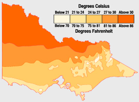
Average January temperatures: Victoria's north is always hotter than coastal and mountainous areas.
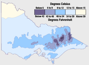
Average July temperatures: Victoria's hills and ranges are coolest during winter. Snow also falls there.
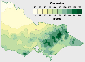
Average yearly precipitation: Victoria's rainfall is concentrated in the mountainous north-east and coast.
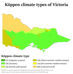
Köppen map of Victoria


غرب أستراليا


| المكان | نمط المناخ | درجة الحرارة العظمى في يناير | درجة الحرارة الدنيا في يناير | درجة الحرارة العظمى في يوليو | درجة الحرارة الدنيا في يوليو | عدد الأيام الصحو | الهطل السنوي |
|---|---|---|---|---|---|---|---|
| Albany[70] | Csb | 23 °C (73 °F) | 15 °C (59 °F) | 16 °C (61 °F) | 8 °C (46 °F) | 45 | 929 mm (37 in) |
| Broome[71] | BSh | 33 °C (91 °F) | 26 °C (79 °F) | 29 °C (84 °F) | 14 °C (57 °F) | 182 | 613 mm (24 in) |
| Eucla[72] | BSk | 26 °C (79 °F) | 17 °C (63 °F) | 18 °C (64 °F) | 7 °C (45 °F) | 94 | 274 mm (11 in) |
| Geraldton[73] | Csa/BSh | 32 °C (90 °F) | 18 °C (64 °F) | 19 °C (66 °F) | 9 °C (48 °F) | 164 | 441 mm (17 in) |
| Kalgoorlie[74] | BSk | 34 °C (93 °F) | 18 °C (64 °F) | 17 °C (63 °F) | 5 °C (41 °F) | 151 | 266 mm (10 in) |
| Karratha[75] | BSh | 36 °C (97 °F) | 27 °C (81 °F) | 26 °C (79 °F) | 14 °C (57 °F) | 158 | 297 mm (12 in) |
| Perth[76] (capital) | Csa | 30 °C (86 °F) | 18 °C (64 °F) | 17 °C (63 °F) | 9 °C (48 °F) | 131 | 868 mm (34 in) |
| Wyndham[77] | BSh | 37 °C (99 °F) | 26 °C (79 °F) | 31 °C (88 °F) | 17 °C (63 °F) | 176 | 824 mm (32 in) |
الجزر الأسترالية النائية
| Island(s) | Climate type | Coordinates | January max. temp | January min. temp | July max. temp | July min. temp | No. clear days | Annual precipitation |
|---|---|---|---|---|---|---|---|---|
| Christmas Island[78] | Am | 10°25′18″S 105°40′41″E / 10.42167°S 105.67806°E | 28 °C (82 °F) | 23 °C (73 °F) | 26 °C (79 °F) | 23 °C (73 °F) | 8 | 2,199 mm (87 in) |
| Cocos (Keeling) Islands[79] | Am | 12°07′S 96°54′E / 12.117°S 96.900°E | 30 °C (86 °F) | 25 °C (77 °F) | 28 °C (82 °F) | 24 °C (75 °F) | N/A | 1,984 mm (78 in) |
| Lord Howe Island[80] | Cfa | 31°33′15″S 159°05′06″E / 31.55417°S 159.08500°E | 25 °C (77 °F) | 21 °C (70 °F) | 19 °C (66 °F) | 14 °C (57 °F) | 68 | 1,464 mm (58 in) |
| Macquarie Island[81] | ET | 54°30′0″S 158°57′0″E / 54.50000°S 158.95000°E | 9 °C (48 °F) | 5 °C (41 °F) | 5 °C (41 °F) | 2 °C (36 °F) | 4 | 993 mm (39 in) |
| Norfolk Island[82] | Cfa | 29°02′S 167°57′E / 29.03°S 167.95°E | 25 °C (77 °F) | 19 °C (66 °F) | 18 °C (64 °F) | 14 °C (57 °F) | 41 | 1,286 mm (51 in) |
| Willis Island[83] | Aw | 16°17′15″S 149°57′52″E / 16.28750°S 149.96444°E | 31 °C (88 °F) | 26 °C (79 °F) | 26 °C (79 °F) | 22 °C (72 °F) | 67 | 1,102 mm (43 in) |
درجات الحرارة

ترتفع درجة حرارة الهواء الملامس لسطح الأرض في الصيف (الجنوبي) بسبب تعامد أشعة الشمس مع مدار الجدي، وتراوح في الأطراف الجنوبية الشرقية والجنوبية الغربية من الجزيرة بين 12.1 و 26.7 درجة مئوية. ويعد القسم الشمالي الغربي من أسترالية أكثر أجزائها حرارة، إذ تزيد حرارة الهواء الملامس لسطحه على 31.1 درجة مئوية. ومتوسط درجة الحرارة في شهر كانون الثاني في سيدني، الواقعة على الساحل الجنوبي الشرقي، 22.5 درجة مئوية. وفي بروم، الواقعة على الساحل الشمالي الغربي، 30 درجة مئوية. أما في الشتاء فتنخفض درجة حرارة الهواء الملامس لسطح الجزيرة كثيراً عما هي عليه في الصيف بسبب تعامد أشعة الشمس مع مدار السرطان. ويصبح الخط الحراري الذي يساوي 13.4 ْْ مئوية منصفاً للجزيرة تقريباً ويقسمها إلى قسمين مختلفين، فترتفع درجة حرارة الهواء الملامس للسطح في القسم الشمالي أكثر من ذلك الرقم، وتنخفض في القسم الجنوبي أقل منه وتبقى الأطراف الشمالية والشمالية الغربية للجزيرة أكثر الأجزاء دفئاً في هذا الفصل، إذ تزيد درجة حرارة الهواء الملامس لسطحها على 22.3 درجة مئوية. ومتوسط درجة حرارة شهر تموز في كوك تاون، الواقعة على الساحل الشمالي الشرقي، هو 26.1 درجة مئوية، وفي ملبورن، الواقعة على الساحل الجنوبي، 9.1 درجة مئوية.
القصوى
A list of extremes can be found in the tables below:
| نطاقات درجات الحرارة المطلقة | ||||||
|---|---|---|---|---|---|---|
| الشهر | درجات الحرارة القصوى | درجات الحرارة الدنيا | ||||
| °س | °ف | الموقع والتاريخ | °C | °F | الموقع والتاريخ | |
| يناير | 50.7 | 123.3 |
Oodnadatta, South Australia (2 January 1960)[84] |
−7.7 | 18.1 |
Thredbo Ski Resort, New South Wales (24 January 2000)[85] |
| فبراير | 50.5 | 122.9 | −7.0 | 19.4 |
Perisher Ski Resort, New South Wales (17 February 1979)[87] | |
| مارس | 48.5 | 119.3 |
Emu Creek Station, Western Australia (11 March 2019)[88] |
−7.2 | 19.0 |
Kiandra, New South Wales (25 March 1964)/Bullocks Flat, New South Wales (31 March 1988)[89] |
| أبريل | 45.0 | 113.0 |
Port Hedland, Western Australia (1 April 1948)/Marble Bar, Western Australia (2 April 1928)[90] |
−13.0 | 8.6 |
Charlotte Pass, New South Wales (29 April 2009)[87] |
| مايو | 40.6 | 105.1 |
Bidyadanga, Western Australia (6 May 1990)[91] |
−13.4 | 7.9 |
Charlotte Pass, New South Wales (24 May 2008)[92] |
| يونيو | 37.8 | 100.0 | −23.0 | −9.4 |
Charlotte Pass, New South Wales (29 June 1994)[94] | |
| يوليو | 37.6 | 99.7 |
Wyndham, Western Australia (19 July 1996)[95] |
−19.6 | −3.3 |
Charlotte Pass, New South Wales (20 July 2010)[96] |
| أغسطس | 41.2 | 106.2 |
West Roebuck, Western Australia (23 August 2020)[97] |
−20.6 | −5.1 |
Charlotte Pass, New South Wales (14 August 1968)[98] |
| سبتمبر | 43.1 | 109.6 |
West Roebuck, Western Australia (27 September 2003)[97] |
−16.7 | 1.9 |
Charlotte Pass, New South Wales (20 September 1967)[99] |
| أكتوبر | 46.9 | 116.4 |
Port Hedland, Western Australia (22 October 2002)[100] |
−12.0 | 10.4 |
Charlotte Pass, New South Wales (29 October 2006)[101] |
| نوفمبر | 48.7 | 119.7 |
Birdsville, Queensland (17 November 1990)[102] |
−9.4 | 15.1 |
Charlotte Pass, New South Wales (26 November 1968)[103] |
| ديسمبر | 49.9 | 121.8 | −9.0 | 15.8 |
Thredbo Ski Resort, New South Wales (13 December 1976)[105] | |
| بيانات مناخ أستراليا | |||||||||||||
|---|---|---|---|---|---|---|---|---|---|---|---|---|---|
| الشهر | يناير | فبراير | مارس | أبريل | مايو | يونيو | يوليو | أغسطس | سبتمبر | اكتوبر | نوفمبر | ديسمبر | العام |
| العظمى القياسية °س (°ف) | 50.7 (123.3) |
50.5 (122.9) |
48.1 (118.6) |
45.0 (113) |
40.6 (105.1) |
37.8 (100) |
37.6 (99.7) |
41.2 (106.2) |
43.1 (109.6) |
46.9 (116.4) |
48.7 (119.7) |
49.9 (121.8) |
50٫7 (123٫3) |
| الصغرى القياسية °س (°ف) | -7.7 (18.1) |
-7.0 (19.4) |
-7.2 (19) |
-13.0 (8.6) |
-13.4 (7.9) |
-23.0 (-9.4) |
-19.6 (-3.3) |
-20.6 (-5.1) |
-16.7 (1.9) |
-12.0 (10.4) |
-9.4 (15.1) |
-9.0 (15.8) |
−23 (−9٫4) |
| Source: Bureau of Meteorology, Australian Government[106] | |||||||||||||
التغير المناخي

الضغط والرياح والأمطار
ينخفض الضغط الجوي صيفاً فوق المناطق الداخلية من الجزيرة، ويبقى مرتفعاً فوق المسطحات المائية المجاورة، فتهب الرياح من المسطحات المائية باتجاه مراكز الضغط المنخفض في القسم الغربي من الجزيرة. وتهب الرياح الموسمية الشمالية على الساحل الشمالي فتسبب هطول أمطار غزيرة فوق السهول المتاخمة. وتقل كمية هذه الأمطار كلما توغلت الرياح المسببة لها جنوباً باتجاه مراكز الضغط المنخفض، ولاسيما بعد أن تجتاز سلاسل جبال باركلي وهضبة كمبرلي.
كما تهب الرياح التجارية الجنوبية الشرقية على السواحل الجنوبية الشرقية والشرقية وتسبب هطول أمطار غزيرة فوق السهول والجبال المتاخمة لها. وتقل كمية هذه الأمطار كلما توغلت الرياح المسببة لها غرباً باتجاه مراكز الضغط المنخفض، ولاسيما بعد أن تجتاز مرتفعات الألب الأسترالية.
كذلك تهب الرياح العكسية الغربية على الأطراف الجنوبية الغربية والجنوبية الشرقية من الجزيرة وتسبب هطول أمطار جيدة على السواحل فقط. أما في الشتاء فيصبح الضغط مرتفعاً فوق المناطق الداخلية من الجزيرة، ويضعف اندفاع الرياح من المسطحات المائية باتجاه هذه المناطق. وينزاح نطاق هبوب الرياح التجارية الجنوبية الشرقية التي تهب على السواحل الجنوبية الشرقية والشرقية شمالاً تبعاً لحركة الشمس الظاهرية، وتضعف شدة اندفاعها وسرعتها نحو الداخل.
وعلى العكس يتسع النطاق الذي تهب فيه الرياح العكسية الغربية ليشمل مناطق أكبر من الأطراف الجنوبية الغربية والجنوبية الشرقية من الجزيرة ويسبب هطول أمطار غزيرة فوقها.
وبسبب ما تقدم يكون الساحل الشمالي من أسترالية ممطراً طوال العام وأغزر مطراً في فصل الصيف. ويكون الساحل الشرقي غزير الأمطار طوال العام وتتساوى أمطاره في كل الفصول تقريباً. أما في الأراضي الجنوبية من أسترالية، فتكون الأجزاء الواقعة جنوب دائرة العرض 35 جنوباً ممطرة طوال العام بفعل الرياح العكسية الغربية. في حين لا تهطل الأمطار على الأجزاء الواقعة بين دائرتي عرض 30 و 35 جنوباً إلا في فصل الشتاء. وتبقى السهول الوسطى الداخلية من أسترالية شبه جافة لوقوعها في مناطق ظل المطر بسبب السلاسل الجبلية المعترضة للرياح المسببة للأمطار وتراوح كمية الأمطار السنوية فيها بين 254 و508 مم. وأعظم أجزاء أسترالية جفافاً هي المناطق الداخلية والغربية فلا تصلها إلا الرياح الجافة وتقل كمية الأمطار فيها عن 127مم. وأما أغزر المناطق مطراً فهي السهول الشرقية والشمالية، والأطراف الجنوبية الغربية، إذ تراوح كمية الأمطار السنوية فوق هذه المناطق بين 1016 مم و 3048 مم.
وأمطار أسترالية مضطربة النظام، ولاسيما في الأجزاء الداخلية. فقد تهطل وابلاً في يوم واحد بكميات كبيرة تصل إلى 89 مم. وقد تمر أشهر عدة من دون أن تهطل قطرة واحدة. وكثيراً ما يسبب عدم الانتظام هذا خسائر كبيرة في الزراعة وتربية الماشية. وإذا أضيف إلى ذلك أثر الزوابع والرياح الشمالية الحارة التي تهب على القسم الجنوبي من أسترالية، يمكن تصور مقدار الخسائر الفادحة التي تحدث بين الحين والآخر.
نماذج المناخ

يميز في الجزيرة، تبعاً لتنوع الشروط المناخية نماذج المناخ التالية:
- المناخ الموسمي المداري: ويشمل القسم الشمالي من الجزيرة. ومتوسط درجة الحرارة فيه صيفاً 30 درجة مئوية. وشتاء 25.1 درجة مئوية. وتهطل الأمطار فيه غزيرة في الصيف، ويعد مناخ مدينة داروين الواقعة في شمال الجزيرة أحسن مثال على ذلك.
- المناخ الصحراوي الحار والجاف: ويغطي معظم النصف الغربي من الجزيرة ووسطها، ويشمل مساحة تزيد على 1.5 مليون كم2. ومتوسط درجة الحرارة فيه صيفاً 28.8 درجة مئوية. وشتاء 11.2 درجة مئوية. ونادراً ما تهطل الأمطار فيه، ولاسيما في الأطراف الغربية من المنطقة التي يغطيها. ويعد مناخ مدينة أليس سپرنگز الواقعة في وسط الجزيرة أحسن مثال عليه.
- المناخ المعتدل المحيطي الدافيء: ويتركز في القسم الجنوبي الشرقي من الجزيرة ويطلق عليه اسم مناخ شرقي أسترالية أيضاً. ويتصف باعتدال درجة الحرارة فيه صيفاً (22.3 درجة مئوية)، وببرودته شتاء (11.2 درجة). وأمطاره غزيرة طول أيام السنة. ويعد مناخ مدينة سيدني الواقعة في جنوب شرقي الجزيرة أحسن مثال عليه.
- مناخ البحر المتوسط (المناخ الرومي): ويسود الأطراف الجنوبية الغربية من الجزيرة وبعض الأجزاء من الأطراف الجنوبية الشرقية. وكلها تقع على درجات عرض المناطق التي يسود فيها المناخ المعتدل المحيطي الدافىء. ويتصف هذا المناخ بجفافه وارتفاع درجة الحرارة فيه صيفاً (22.8 درجة مئوية) وجودة الأمطار واعتدال الحرارة شتاء (12.8 درجة مئوية). ويعد مناخ مدينة پرث الواقعة في جنوب غربي الجزيرة أحسن مثال عليه.
انظر أيضاً
- Indigenous Australian seasons
- List of wettest known tropical cyclones in Australia
- Weather extremes in Australia, an index of extreme Australian weather articles
الهامش
- ^ Scientists Trace Extreme Heat in Australia to Climate Change 29 September 2014 NYT
- ^ "State of the Climate 2014". Bureau of Meteorology. Retrieved 29 March 2014.
- ^ "CSIRO report says Australia getting hotter with more to come". ABC Online. 4 March 2014. Retrieved 20 April 2014.
- ^ "Stats" (Australian Government)
- ^ Climate of Australia
- ^ Precipitation in Australia. Routledge. 1997. p. 376. ISBN 978-0-415-12519-2.
{{cite book}}:|work=ignored (help) - ^ "Canberra: Climate and water". bom.gov.au. Retrieved 11 February 2020.
- ^ Territory, Bureau of Meteorology Australian Capital (3 January 2020). "Untitled". @BOM_ACT (in الإنجليزية). Retrieved 4 January 2020.
Canberra has reached 43.6C—a new hottest temperature record for any month. The previous Canberra records are 42.2C at Canberra Airport in 1968 and 42.8C at the now-closed Acton site in 1939.
- ^ Australian Bureau of Statistics, 2002 Yearbook of Australia Archived 12 أكتوبر 2012 at the Wayback Machine. Retrieved 22 July 2007.
- ^ Southerly Busters Explained. The Australian Government Bureau of Meteorology. Retrieved 21 February 2012.
- ^ أ ب ت ث "Rainfall and Temperature Records: National" (PDF). Bureau of Meteorology (BOM). Retrieved 17 November 2009.
- ^ "Climate statistics for Australian locations". bom.gov.au. Bureau of Meteorology. Retrieved 10 January 2020.
- ^ "Climate statistics for Australian locations". bom.gov.au. Bureau of Meteorology. Retrieved 10 January 2020.
- ^ "Armidale Climate Statistics". BOM. Retrieved 16 April 2009.
- ^ "Broken Hill Airport Climate Statistics". BOM. Retrieved 16 April 2009.
- ^ "Climate statistics for Australian locations". bom.gov.au. Retrieved 8 January 2020.
- ^ "Coffs Harbour Climate Statistics". BOM. Retrieved 16 April 2009.
- ^ "Orange Climate Statistics". BOM. Retrieved 10 January 2017.
- ^ "Penrith Lakes Climate Statistics". BOM. Retrieved 16 April 2009.
- ^ "Sydney (Observatory Hill) Climate Statistics". BOM. Retrieved 16 April 2009.
- ^ "Wagga Wagga Climate Statistics". BOM. Retrieved 16 April 2009.
- ^ "Wollongong Climate Statistics". BOM. Retrieved 16 April 2009.
- ^ "Summary statistics Darwin Airport". BOM. 15 July 2009. Retrieved 26 July 2009.
- ^ "Summary statistics Alice Springs Airport". BOM. 16 July 2009. Retrieved 26 July 2009.
- ^ "CHAPTER 7: Introduction to the Atmosphere". physicalgeography.net. Retrieved 15 July 2008.
- ^ BOM – Climate of Queensland
- ^ BOM – Australian climatic zones[dead link]
- ^ "Climate statistics for Australian locations". bom.gov.au. Retrieved 8 January 2020.
- ^ "Brisbane Climate Statistics". BOM. Retrieved 5 January 2017.
- ^ "Cairns Climate Statistics". BOM. Retrieved 5 January 2017.
- ^ "Gold CoastClimate Statistics". BOM. Retrieved 5 January 2017.
- ^ "Mackay Climate Statistics". BOM. Retrieved 5 January 2017.
- ^ "Mt Isa Climate Statistics". BOM. Retrieved 5 January 2017.
- ^ "Rockhampton Climate Statistics". BOM. Retrieved 5 January 2017.
- ^ "Climate statistics for Australian locations". bom.gov.au. Retrieved 7 January 2020.
- ^ "Towoomba Climate Statistics". BOM. Retrieved 5 January 2017.
- ^ "Townsville Climate Statistics". BOM. Retrieved 5 January 2017.
- ^ "Climate statistics for Australian locations". bom.gov.au. Retrieved 8 January 2020.
- ^ "Archived copy". Archived from the original on 15 March 2010. Retrieved 6 December 2009.
{{cite web}}: CS1 maint: archived copy as title (link) - ^ "Adelaide Climate Statistics". BOM. Retrieved 8 January 2017.
- ^ "Climate statistics for Australian locations". bom.gov.au. Retrieved 8 January 2020.
- ^ "Mount Gambier Climate Statistics". BOM. Retrieved 8 January 2017.
- ^ "Oodnadatta Climate Statistics". BOM. Retrieved 5 January 2017.
- ^ "Port Augusta Climate Statistics". BOM. Retrieved 8 January 2017.
- ^ "Climate statistics for Australian locations". bom.gov.au. Retrieved 26 December 2019.
- ^ "Whyalla Climate Statistics". BOM. Retrieved 8 January 2017.
- ^ "Climate of Launceston". BOM. Archived from the original on 22 February 2009. Retrieved 1 January 2009.
- ^ McIntyre, Damian (7 August 2020). "Liawenee in Tasmania's Central Highlands breaks record for coldest temperature in island state". ABC News. Retrieved 8 August 2020.
- ^ "Climate statistics for Australian locations". bom.gov.au. Retrieved 8 January 2020.
- ^ "Devonport Climate Statistics". BOM. Retrieved 8 January 2017.
- ^ "Climate statistics for Australian locations". bom.gov.au. Retrieved 9 January 2020.
- ^ "Hobart Climate Statistics". BOM. Retrieved 8 January 2017.
- ^ "Climate statistics for Australian locations". bom.gov.au. Retrieved 8 January 2020.
- ^ "Launceston Climate Statistics". BOM. Retrieved 8 January 2017.
- ^ "Climate statistics for Australian locations". bom.gov.au. Retrieved 13 January 2020.
- ^ "Climate statistics for Australian locations". bom.gov.au. Retrieved 7 January 2020.
- ^ "Climate statistics for Australian locations". bom.gov.au. Retrieved 9 January 2020.
- ^ "Strahan Climate Statistics". BOM. Retrieved 8 January 2017.
- ^ "Bairnsdale Climate Statistics". BOM. Retrieved 17 January 2017.
- ^ "Ballarat Climate Statistics". BOM. Retrieved 17 January 2017.
- ^ "Bendigo Climate Statistics". BOM. Retrieved 17 January 2017.
- ^ "Climate statistics for Australian locations". bom.gov.au. Retrieved 9 January 2020.
- ^ "Climate statistics for Australian locations". bom.gov.au. Retrieved 8 January 2020.
- ^ "Climate statistics for Australian locations". bom.gov.au. Retrieved 8 January 2020.
- ^ "Melbourne Climate Statistics". BOM. Retrieved 17 January 2017.
- ^ "Mildura Climate Statistics". BOM. Retrieved 17 January 2017.
- ^ "Climate statistics for Australian locations". bom.gov.au. Retrieved 8 January 2020.
- ^ "Shepparton Climate Statistics". BOM. Retrieved 17 January 2017.
- ^ "Warnambool Climate Statistics". BOM. Retrieved 17 January 2017.
- ^ "Albany Climate Statistics". BOM. Retrieved 10 January 2017.
- ^ "Broome Climate Statistics". BOM. Retrieved 10 January 2017.
- ^ "Climate statistics for Australian locations". bom.gov.au. Retrieved 9 January 2020.
- ^ "Geraldton Climate Statistics". BOM. Retrieved 10 January 2017.
- ^ "Kalgoorlie Climate Statistics". BOM. Retrieved 10 January 2017.
- ^ "Karratha Climate Statistics". BOM. Retrieved 10 January 2017.
- ^ "Perth Climate Statistics". BOM. Retrieved 10 January 2017.
- ^ "Climate statistics for Australian locations". bom.gov.au. Retrieved 8 January 2020.
- ^ "Climate statistics for Australian locations". bom.gov.au. Retrieved 8 January 2020.
- ^ "Climate statistics for Australian locations". bom.gov.au. Retrieved 8 January 2020.
- ^ "Climate statistics for Australian locations". bom.gov.au. Retrieved 8 January 2020.
- ^ "Climate statistics for Australian locations". bom.gov.au. Retrieved 8 January 2020.
- ^ "Climate statistics for Australian locations". bom.gov.au. Retrieved 8 January 2020.
- ^ "Climate statistics for Australian locations". bom.gov.au. Retrieved 8 January 2020.
- ^ "Official records for Australia in January". Daily Extremes. BOM. 31 July 2013. Retrieved 12 March 2013.
- ^ "Official records for Australia in January". Daily Extremes. BOM. 31 July 2013. Retrieved 12 March 2013.
- ^ "Official records for Australia in January". Daily Extremes. BOM. 31 July 2013. Retrieved 12 March 2013.
- ^ أ ب "Official records for Australia in January". Daily Extremes. BOM. 31 July 2013. Retrieved 12 March 2013.
- ^ "Australian daily extremes tables". Bureau of Meteorology. Commonwealth of Australia. 2021. Retrieved 25 May 2021.
- ^ "Official records for Australia in January". Daily Extremes. BOM. 31 July 2013. Retrieved 12 March 2013.
- ^ "Official records for Australia in January". Daily Extremes. BOM. 31 July 2013. Retrieved 12 March 2013.
- ^ "Official records for Australia in January". Daily Extremes. BOM. 31 July 2013. Retrieved 12 March 2013.
- ^ "Official records for Australia in January". Daily Extremes. BOM. 31 July 2013. Retrieved 12 March 2013.
- ^ "Official records for Australia in January". Daily Extremes. BOM. 31 July 2013. Retrieved 12 March 2013.
- ^ "Official records for Australia in January". Daily Extremes. BOM. 31 July 2013. Retrieved 12 March 2013.
- ^ "Official records for Australia in January". Daily Extremes. BOM. 31 July 2013. Retrieved 12 March 2013.
- ^ "Official records for Australia in January". Daily Extremes. BOM. 31 July 2013. Retrieved 12 March 2013.
- ^ أ ب "Official records for Australia in January". Daily Extremes. BOM. 23 August 2020. Retrieved 3 September 2020.
- ^ "Official records for Australia in January". Daily Extremes. BOM. 31 July 2013. Retrieved 12 March 2013.
- ^ "Official records for Australia in January". Daily Extremes. BOM. 31 July 2013. Retrieved 12 March 2013.
- ^ "Official records for Australia in January". Daily Extremes. BOM. 31 July 2013. Retrieved 12 March 2013.
- ^ "Official records for Australia in January". Daily Extremes. BOM. 31 July 2013. Retrieved 12 March 2013.
- ^ "Official records for Australia in January". Daily Extremes. BOM. 31 July 2013. Retrieved 12 March 2013.
- ^ "Official records for Australia in January". Daily Extremes. BOM. 31 July 2013. Retrieved 12 March 2013.
- ^ "Official records for Australia in December". Daily Extremes. BOM. 22 December 2019. Retrieved 23 December 2019.
- ^ "Official records for Australia in January". Daily Extremes. BOM. 31 July 2013. Retrieved 12 March 2013.
- ^ Bureau of Meteorology, Australian Government