ملف:Near east lrg.jpg

الملف الأصلي (3٬002 × 4٬002 بكسل حجم الملف: 1٫96 ميجابايت، نوع MIME: image/jpeg)
| ⧼wm-license-information-description⧽ |
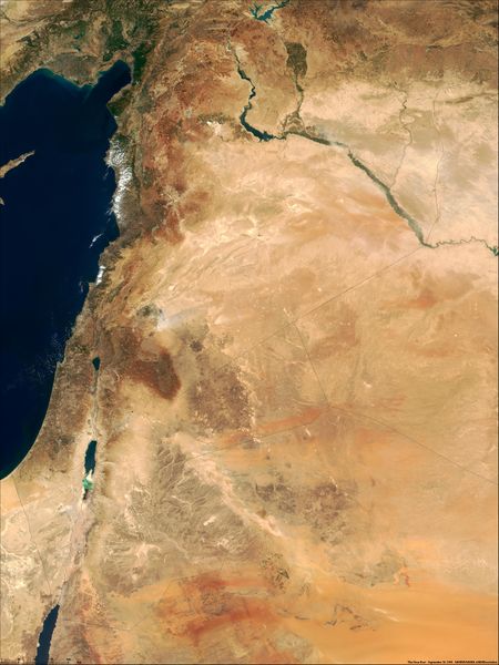
This true-color image of the region was taken on September 10, 2000, by the MODerate-resolution Imaging Spectroradiometer (MODIS) flying aboard NASA's Terra spacecraft. The image shows the lands of Israel along the eastern shore of the Mediterranean Sea, with the countries of Jordan to the southeast and Syria to the Northeast. Jerusalem is Israel's capital city and Aman is the capital of Jordan. The region known as the West Bank lies between the two countries. Running from north to south, the Jordan River links the Sea of Galilee to the Dead Sea. Image courtesy Jacques Descloitres, MODIS Land Group, NASA GSFC |
| ⧼wm-license-information-date⧽ | image taken on 10. Sep. 2000 |
| ⧼wm-license-information-source⧽ | http://earthobservatory.nasa.gov/Newsroom/NewImages/Images/modis_near_east_lrg.jpg |
| ⧼wm-license-information-author⧽ | NASA, earthobservatory, http://earthobservatory.nasa.gov/ |
| ⧼wm-license-information-permission⧽ (⧼wm-license-information-permission-reusing-text⧽) |
PD-USGov-NASA |
Error in template * unknown parameter name (Template:Information): '1'
تاريخ الملف
اضغط على زمن/تاريخ لرؤية الملف كما بدا في هذا الزمن.
| زمن/تاريخ | صورة مصغرة | الأبعاد | مستخدم | تعليق | |
|---|---|---|---|---|---|
| حالي | 19:25، 13 مارس 2010 | | 3٬002 × 4٬002 (1٫96 ميجابايت) | Shafei (نقاش | مساهمات) |
لا يمكنك استبدال هذا الملف.
وصلات
الصفحات التالية تحتوي على وصلة لهذه الصورة: