محافظة چنققلعه
محافظة چنققلعه Çanakkale Province (تركية: Çanakkale ili)، هي إحدى محافظات تركيا، وتقع في منطقة مرمرة شمال غرب البلاد. سميت المحافظة على اسم عاصمتها چنققلعه. تبلغ مساحتها 9,887 كم² ويبلغ عدد سكانها 464,975 نسمة كما يبلغ معدل الكثافة السكانية 47/كم² تقع في شمال غرب تركيا. ومثل اسطنبول، محافظة چناق قلعة لها جزء في قارة آسيا وآخر في اوروبا. الجزء الاوروبي هو شبه جزيرة گاليپولي (بالتركية: غالب اوغلو) والجزء الآسيوي هو منطقة طروادة التاريخية. ويفصل بينهم مضيق الدردنيل الواصل بين بحر مرمرة وبحر إيجة.
چنققلعه
Çanakkale ili | |
|---|---|
 | |
 موقع محافظة چنققلعه في تركيا | |
 أقضية محافظة چنققلعه | |
| البلد | تركيا |
| المنطقة | مرمرة |
| العاصمة | چنققلعه |
| المساحة | |
| • الإجمالي | 9٬737 كم² (3٬759 ميل²) |
| التعداد (2010-12-31)[1] | |
| • الإجمالي | 490٬397 |
| • الكثافة | 50/km2 (130/sq mi) |
| مفتاح الهاتف | 0286 |
| لوحة السيارة | 17 |
| الموقع الإلكتروني | چنققلعه.gov.tr |
الموقع الأثري طروادة يوجد في محافظة چنققلعه.
Çanakkale is the biggest district of the province. The European and Asian parts of the province were connected to each other with the completion of the Çanakkale 1915 Bridge in March 2022.
. . . . . . . . . . . . . . . . . . . . . . . . . . . . . . . . . . . . . . . . . . . . . . . . . . . . . . . . . . . . . . . . . . . . . . . . . . . . . . . . . . . . . . . . . . . . . . . . . . . . . . . . . . . . . . . . . . . . . . . . . . . . . . . . . . . . . . . . . . . . . . . . . . . . . . . . . . . . . . . . . . . . . . . .
التاريخ
In the early Turkish Republic, the Çanakkale Province came into existence with the abolition of the Ottoman-era sanjaks of Biga and Gelibolu. According to a population census in 1927, Çanakkale had 8,500 inhabitants, except its neighbouring villages. It is recorded that Çanakkale, which was also called as "Hellespontos" and "Dardanelles" in ancient times, has accommodated to many civilizations for about 3,000 years. Even the Archaic Troy (Troia) city, where was governed by Lydians and destroyed by the devastating earthquake in 2500 BC, has ruins in today. في 336 ق.م.، الامبراطورية الفارسية التي أصبحت قوة بارزة في الأناضول و was conducted by Alexander the Great that aimed to extend ancient Greece all over the world, was defeated. Also with the ruin of the Anatolian beylik of Karesi, most of the territory of Çanakkale was conquered in the Ottoman era, with the assistance of the castles in remuneration for helping to Byzantine Empire, locating Gelibolu. Afterwards, the Çanakkale strait was given to the Ottoman Empire.

The province was included in the Second Inspectorate General on the 19 February 1934 which span over the provinces of Edirne, Çanakkale, Kırklareli, Tekirdağ.[2] It was ruled by an Inspector General who had wide-ranging authorities over civilian, military and educational matters.[3] The office of the Inspectorate-General was abandoned in 1948[4] but the legal framework of the Inspectorate-Generals was only abolished in 1952, under the Government of the Democrat Party.[5]
الزراعة
The province of Çanakkale is a notable region for viticulture and winemaking in Turkey. The region between Saros Gulf and Gelibolu on the Gallipoli peninsula is cultivated with vineyards.[6] Wine producer "Suvla" is located in Suvla.[7]
المقاطعات
تنقسم محافظة چنققلعه إلى 12 مقاطعة (المقاطعة العاصمة بالخط العريض):
معرض الصور
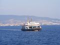
عبارة تمخر عباب بحر مرمرة من بلدة چنققلعه إلى شبه جزيرة گاليپولي
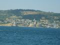
منظرچنققلعه من الدردنيل

برج الساعة التاريخي في وسط بلدة چنققلعه


المصادر
- ^ Turkish Statistical Institute, MS Excel document – Population of province/district centers and towns/villages and population growth rate by provinces
- ^ Cagaptay, Soner (2006). Islam, Secularism, and Nationalism in Modern Turkey; Who is a Turk. Routledge. p. 47.
- ^ Pekesen, Berna (16 December 2019). Florian, Riedler; Kravietz, Birgit (eds.). The Heritage of Edirne in Ottoman and Turkish Times: Continuities, Disruptions and Reconnections (in الإنجليزية). Walter de Gruyter GmbH & Co KG. pp. 423–424. ISBN 978-3-11-063908-7.
- ^ Bayir, Derya (2016-04-22). Minorities and Nationalism in Turkish Law (in الإنجليزية). Routledge. p. 141. ISBN 978-1-317-09579-8.
- ^ Bozarslan, Hamit (2008-04-17). Fleet, Kate; Faroqhi, Suraiya; Kasaba, Reşat; Kunt, I. Metin (eds.). The Cambridge History of Turkey (in الإنجليزية). Cambridge University Press. p. 343. ISBN 978-0-521-62096-3.
- ^ خطأ استشهاد: وسم
<ref>غير صحيح؛ لا نص تم توفيره للمراجع المسماةh1 - ^ خطأ استشهاد: وسم
<ref>غير صحيح؛ لا نص تم توفيره للمراجع المسماةcr
وصلات خارجية
- (إنگليزية) الموقع الرسمي لحاكم محافظة چنققلعه
- (إنگليزية) الموقع الرسمي لبلدية چنققلعه
- (إنگليزية) معلومات عن الطقس في چنققلعه
Coordinates: 40°02′27″N 26°33′37″E / 40.04083°N 26.56028°E