كونسپسيون، تشيلى
كونسپسيون (Concepción؛ النطق الإسپاني: [kon.sepˈsjon]; in full: Concepción de la Madre Santísima de la Luz, "Conception of the Blessed Mother of Light") is a city in central Chile and the core of the commune and metropolitan area of Greater Concepción, the country's second largest urban conurbation.[2] It has a significant impact on domestic trade[3] being part of the most heavily industrialized region in the country.[4] Its location is in the called Zona Centro Sur (Central South Zone), in the geographic center of the country,[5] and it is the capital of the Concepción Province and Bío Bío Region. It sits about 500 km south of Santiago, the country's capital.
كونسپسيون
Concepción La Concepción de María Purísima del Nuevo Extremo (original name) | |
|---|---|
 كولاج من كونسپسيون، أعلى: الأفق؛ أعلى اليسار: جامعة كونسپسيون؛ أعلى اليمين: محل في وسط البلد؛ وسط اليسار: منتزه إكوادور؛ وسط الوسط: Bonilla/Alonso de Ribera Highway؛ وسط اليمين: برج الساعة في جامعة كونسپسيون؛ أسفل اليسار: Lautaro statue؛ أسفل الوسط: جامعة سان سباستيان؛ أسفل الوسط: محكمة الاستئناف؛ أسفل اليمين: بيوترين. | |
 Flag .svg) Coat of arms  Location in the Bío Bío Region  كونسپسيون Location in Chile | |
| الكنية: Biobío's Pearl, The University City, The cradle of Chilean rock | |
| الشعار: La Capital del Sur de Chile The Capital of Southern Chile | |
| الإحداثيات (Alcalde's office): 36°49′41.50″S 73°03′04.93″W / 36.8281944°S 73.0513694°WCoordinates: 36°49′41.50″S 73°03′04.93″W / 36.8281944°S 73.0513694°W | |
| البلد | تشيلى |
| المنطقة | بيو بيو |
| المقاطعة | كونسپسيون |
| تأسست | October 5, 1550 |
| أسسها | پدرو دى ڤالديڤيا |
| الحكومة | |
| • النوع | بلدية |
| • Alcalde | Álvaro Ortiz (DC) |
| المساحة | |
| • City and Commune | 222 كم² (86 ميل²) |
| المنسوب | 12 m (39 ft) |
| التعداد (2006) | |
| • City and Commune | 992٬589 |
| • الكثافة | 1٬318/km2 (3٬410/sq mi) |
| • العمرانية | 1٬322٬581 |
| صفة المواطن | Penquista |
| منطقة التوقيت | UTC−4 (CLT) |
| • الصيف (التوقيت الصيفي) | UTC−3 (CLST) |
| Post code | 3349001 |
| Telephone prefix | 56 + 41 |
| Climate | Csb |
| الموقع الإلكتروني | www |
Greater Concepción (Gran Concepción, including Talcahuano, San Pedro de la Paz, Hualpén, Chiguayante, Penco, Tomé, Lota, Coronel, Hualqui and Concepción) is the second-largest conurbation in the country, with 945,650 inhabitants (2012 census). Individually, it is the 11th largest commune in the country, with a population of 229,665.[6]
. . . . . . . . . . . . . . . . . . . . . . . . . . . . . . . . . . . . . . . . . . . . . . . . . . . . . . . . . . . . . . . . . . . . . . . . . . . . . . . . . . . . . . . . . . . . . . . . . . . . . . . . . . . . . . . . . . . . . . . . . . . . . . . . . . . . . . . . . . . . . . . . . . . . . . . . . . . . . . . . . . . . . . . .
التاريخ
.jpg)
.jpg)
Concepción was founded by Pedro de Valdivia[FN 1] in 1550 north of the Bío Bío River, at the site which is today known as Penco. At that time it was given the name Concepción de María Purísima del Nuevo Extremo (Mary Immaculate Conception of the New End). The new settlement of Concepción was just a few kilometers north of La Frontera (The Frontier), the boundary between Spanish territory and the land of the Mapuche, an American Indian ethnic group that remained independent until the 1870s. The settlement was formally recognized by the Spanish authorities as a town two years later by a royal decree. It was given a coat-of-arms that is still in use today.
At the time of the Spanish arrival to the Concepción area chronicler Jerónimo de Vivar noted local Mapuches wore gold and silver bracelets and "sort of crowns". This is interpreted either as Incan gifts, war spoils from defeated Incas, or adoption of Incan metallurgy.[7]
المواصلات
The city is served by Carriel Sur International Airport in Talcahuano.
المناخ
The climate of Concepción is classified as Köppen Csb, with a dry summer nadir in February. The cool waters of the Pacific Ocean help to maintain mild temperatures throughout the year. Temperatures rarely exceed 30 °C (86 °F) or fall below 0 °C (32.0 °F). In the six-month period between May and October, the city receives approximately 83% of its total annual precipitation, which totals 1,130 mm (44 in). The wettest month since records began in 1912 was June 2000 with 565.7 millimetres (22.3 in), whilst all months from November to April have been rainless on occasions.[8] The maritime cooling brings much cooler temperatures than nearby inland areas on the same parallel in Argentina, where average summer highs match Concepción's all-time records. Summer temperatures for the 36 degrees latitude are rarely as cool as they are in Concepción, and on the Atlantic coast of Argentina, similar or hotter summer temperatures are found much further from the equator. However, this moderation is evident for the entire Chilean Pacific so is not unique for Concepción. Similar cool-summer mediterranean climate tendencies are found on the West Coast of North America on similar parallels, even though Concepción tends to have slightly wetter winters than San Francisco for example. Conversely, record winter nighttime temperatures in Concepcion are significantly more moderate than temperatures recorded on the Argentine Atlantic coast at the same latitude, where temperatures below −10 °C (14 °F) have occurred.[9]
| بيانات مناخ Concepción, Chile (Carriel Sur International Airport) 1981–2010, extremes 1966–present | |||||||||||||
|---|---|---|---|---|---|---|---|---|---|---|---|---|---|
| الشهر | يناير | فبراير | مارس | أبريل | مايو | يونيو | يوليو | أغسطس | سبتمبر | اكتوبر | نوفمبر | ديسمبر | العام |
| العظمى القياسية °س (°ف) | 34.1 (93.4) |
33.2 (91.8) |
30.9 (87.6) |
27.2 (81) |
25.8 (78.4) |
22.0 (71.6) |
21.7 (71.1) |
25.0 (77) |
28.8 (83.8) |
27.6 (81.7) |
32.5 (90.5) |
33.4 (92.1) |
34٫1 (93٫4) |
| العظمى المتوسطة °س (°ف) | 22.8 (73) |
22.5 (72.5) |
21.0 (69.8) |
18.3 (64.9) |
15.4 (59.7) |
13.7 (56.7) |
13.2 (55.8) |
14.0 (57.2) |
15.5 (59.9) |
17.2 (63) |
19.4 (66.9) |
21.4 (70.5) |
17٫9 (64٫2) |
| المتوسط اليومي °س (°ف) | 16.5 (61.7) |
15.9 (60.6) |
14.5 (58.1) |
12.3 (54.1) |
10.7 (51.3) |
9.5 (49.1) |
8.8 (47.8) |
9.3 (48.7) |
10.2 (50.4) |
11.9 (53.4) |
13.8 (56.8) |
15.6 (60.1) |
12٫4 (54٫3) |
| الصغرى المتوسطة °س (°ف) | 10.9 (51.6) |
10.6 (51.1) |
9.8 (49.6) |
8.1 (46.6) |
7.5 (45.5) |
6.6 (43.9) |
5.8 (42.4) |
6.0 (42.8) |
6.1 (43) |
7.4 (45.3) |
8.7 (47.7) |
10.1 (50.2) |
8٫1 (46٫6) |
| الصغرى القياسية °س (°ف) | 0.9 (33.6) |
3.6 (38.5) |
1.6 (34.9) |
-1.0 (30.2) |
-2.1 (28.2) |
-2.2 (28) |
-3.8 (25.2) |
-2.5 (27.5) |
-1.4 (29.5) |
-0.8 (30.6) |
1.0 (33.8) |
3.4 (38.1) |
−3٫8 (25٫2) |
| هطول mm (inches) | 15.7 (0.618) |
15.4 (0.606) |
25.4 (1) |
72.4 (2.85) |
182.7 (7.193) |
230.7 (9.083) |
198.4 (7.811) |
153.6 (6.047) |
84.1 (3.311) |
57.2 (2.252) |
33.4 (1.315) |
21.3 (0.839) |
1٬090٫3 (42٫925) |
| % Humidity | 75 | 77 | 80 | 83 | 87 | 88 | 86 | 85 | 82 | 81 | 78 | 76 | 82 |
| Avg. rainy days (≥ 1.0 mm) | 2.6 | 2.6 | 3.7 | 7.6 | 14.5 | 16.1 | 15.3 | 13.5 | 10.2 | 7.6 | 4.8 | 3.5 | 102٫0 |
| Sunshine hours | 334.8 | 271.2 | 248.0 | 183.0 | 136.4 | 108.0 | 133.3 | 155.0 | 192.0 | 238.7 | 282.0 | 331.7 | 2٬614٫1 |
| Source #1: Dirección Meteorológica de Chile (precipitation days and humidity 1970–2000)[10][11][12] | |||||||||||||
| Source #2: Universidad de Chile (sunshine hours only)[13] | |||||||||||||
As might be expected for such a large urban area heavily dependent on wood-burning for heat and diesel for transport, the air in Concepción is the third-most polluted in Chile, after Santiago and Temuco.[14]
الديمغرافيا
| التعداد التاريخي | ||
|---|---|---|
| السنة | تعداد | ±% سنوياً |
| 1970 | 161٬006 | — |
| 1982 | 267٬891 | +4.33% |
| 1992 | 326٬784 | +2.01% |
| 2002 | 216٬061 | −4.05% |
| 2006 | 225٬158 | +1.04% |
| 2012 | 229٬684 | +0.33% |
| المصدر: 1970–1992,[15] 2002,[16] 2006–2012[17] | ||
. . . . . . . . . . . . . . . . . . . . . . . . . . . . . . . . . . . . . . . . . . . . . . . . . . . . . . . . . . . . . . . . . . . . . . . . . . . . . . . . . . . . . . . . . . . . . . . . . . . . . . . . . . . . . . . . . . . . . . . . . . . . . . . . . . . . . . . . . . . . . . . . . . . . . . . . . . . . . . . . . . . . . . . .
بلدات توأم – مدن شقيقة
المدن التالية لديها علاقات توأمة مع كونسپسيون.
معرض صور

Arco de Medicina ("Arch of Medicine"), on the campus of the Universidad de Concepción
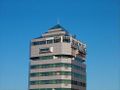
Andes Tower

Mouth of the Bío Bío River emptying into the Pacific Ocean
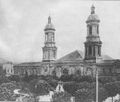
Cathedral of Concepción; it was demolished after an earthquake in 1939
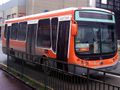
BioBus, transport to a train station
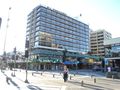
Hotel Araucano
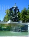
Sculpture Homage to the spirit of the founders of the University of Concepción
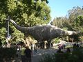
Diplodocus in the Jurassic Park of the Plaza Acevedo.
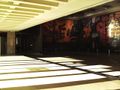
Entrance Casa del Arte together with the mural Presencia de América Latina.
Plaza de la Independencia, the Plaza de Armas of Concepcion

View of Ecuador Park, on the slopes of Cerro Caracol.
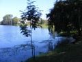
Lo Méndez Lagoon.


انظر أيضاً
المراجع
- Ida Stevenson Weldon Vernon (1969) Pedro de Valdivia, Conquistador of Chile, Greenwood Press
- John Milton Nickles, Marie Siegrist (1965) Bibliography and Index of Geology Exclusive of North America, Geological Society of America, v.28
ملاحظات
- ^ I.S.W. Vernon, 1969
الهامش
- ^ "Municipality of Concepción" (in الإسبانية). Archived from the original on 11 February 2010. Retrieved 3 September 2010.
- ^ Quezada, Rojas; Alejandra, Carolina; Muñiz Olivera, Iván; García-López, Miguel Ángel (1 August 2009). "Estructura urbana y policentrismo en el Área Metropolitana de Concepción". 35 (105): 47–70. doi:10.4067/S0250-71612009000200003. Archived from the original on 12 January 2017. Retrieved 31 October 2016 – via SciELO.
{{cite journal}}: Cite journal requires|journal=(help) - ^ "Concepción: la nueva capital de negocios del sur de Chile – soyconcepcion.cl". soychile.cl. Archived from the original on 2013-12-03. Retrieved 2013-01-16.
- ^ "INE – Error 404" (PDF). www.ine.cl. Archived (PDF) from the original on 2013-01-26. Retrieved 2013-01-16.
- ^ Coronel.cl. "Hito Centro Geográfico de Chile Continental" (in Spanish). Archived from the original on 2013-12-15. Retrieved 20 January 2013.
Playa Blanca (comuna de Coronel, corresponde a la representación del Centro Geográfico de Chile Continental. El Hito corresponde a una estructura monolítica de hormigón de tan solo 2,5 metros de altura, y posee una forma de flecha que indica la orientación Norte-Arica y Sur-Punta Arenas.
{{cite web}}: CS1 maint: unrecognized language (link) - ^ Según proyecciones del INE.
- ^ Silva Galdames, Osvaldo (1983). "¿Detuvo la batalla del Maule la expansión inca hacia el sur de Chile?". Cuadernos de Historia (in Spanish). 3: 7–25. Archived from the original on February 1, 2019. Retrieved January 10, 2019.
{{cite journal}}: CS1 maint: unrecognized language (link) - ^ Climate explorer for Concepción
- ^ [1] Archived 2019-02-07 at the Wayback Machineقالب:Servicio Meteorologico Nacional
- ^ "Datos Normales y Promedios Históricos Promedios de 30 años o menos" (in Spanish). Dirección Meteorológica de Chile. Archived from the original on 17 September 2018. Retrieved 10 December 2018.
{{cite web}}: CS1 maint: unrecognized language (link) - ^ "Temperatura Histórica de la Estación Carriel Sur, Concepción. (360019)" (in Spanish). Dirección Meteorológica de Chile. Archived from the original on 6 December 2018. Retrieved 10 December 2018.
{{cite web}}: CS1 maint: unrecognized language (link) - ^ "Estadistica Climatologica Tomo II" (PDF) (in Spanish). Dirección General de Aeronáutica Civil. مارس 2001. pp. 89–161. Archived from the original (PDF) on مارس 3, 2016. Retrieved مارس 17, 2014.
{{cite web}}: CS1 maint: unrecognized language (link) - ^ "Tabla 4.6: Medias mensuales de horas de sol diarias extraídas del WRDC ruso (en (hrs./dia))" (PDF). Elementos Para La Creación de Un Manual de Buenas Prácticas Para Instalaciones Solares Térmicas Domiciliarias (in Spanish). Universidad de Chile. September 2007. p. 81. Archived from the original on 22 January 2015. Retrieved 21 January 2015.
{{cite web}}: CS1 maint: unrecognized language (link) - ^ Severe air pollution plagues Chilean cities Archived 2014-05-25 at the Wayback Machine Friday, June 29th 2007 – 21:00 UTC
- ^ حسب Last 5 census, the INE
- ^ According to Census 2002, operated by the INE. Note that the agency's projections indicate that 2006 the estimated population of 225,158 inhabitants.
- ^ Projections by the INE.
وصلات خارجية
- El Sur El Sur, newspaper of Concepción (بالإسپانية)
- Viveconce, Event schedule of Concepción (بالإسپانية)
- Source about Concepción – Encyclopædia Britannica
- Geographical coordinates and NASA images, Google
 Concepción travel guide from Wikivoyage