فوگو، الرأس الأخضر
فوگو (Fogo بالبرتغالية هي "النار") هي جزيرة في مجموعة جزر سوتاڤنتو في الرأس الأخضر. ويبلغ تعدادها 35,837 (في 2015)،[1] بمساحة 476 كم².[1] وترتفع لأعلى منسوب في كل جزر الرأس الأخضر، وهو 2,829 متر فوق سطح البحر على قمة بركانها النشط، پيكو دو فوگو.[1]
 | |
 | |
 Fogo  Fogo | |
| الجغرافيا | |
|---|---|
| الموقع | المحيط الأطلسي |
| الإحداثيات | 14°57′00″N 24°20′33″W / 14.9500°N 24.3425°WCoordinates: 14°57′00″N 24°20′33″W / 14.9500°N 24.3425°W |
| الأرخبيل | جزر سوتاڤنتو |
| المساحة | 476 km2 (184 sq mi) |
| الطول | 26٫3 km (16٫34 mi) |
| العرض | 23٫9 km (14٫85 mi) |
| أعلى منسوب | 2٬829 m (9٬281 ft) |
| أعلى نقطة | پيكو دو فوگو |
| الإدارة | |
| Concelhos (بلديات) | Mosteiros, Santa Catarina do Fogo, ساو فيليپي |
| Largest settlement | ساو فيليپي (pop. ساو فيليپي) |
| السكان | |
| التعداد | 35,837 (2015) |
| الكثافة السكانية | 75٫3 /km2 (195 /sq mi) |
. . . . . . . . . . . . . . . . . . . . . . . . . . . . . . . . . . . . . . . . . . . . . . . . . . . . . . . . . . . . . . . . . . . . . . . . . . . . . . . . . . . . . . . . . . . . . . . . . . . . . . . . . . . . . . . . . . . . . . . . . . . . . . . . . . . . . . . . . . . . . . . . . . . . . . . . . . . . . . . . . . . . . . . .
التاريخ
The eastern side of Fogo collapsed into the ocean 73,000 years ago, creating a tsunami 170 meters high which struck the nearby island of Santiago.[2]
اِكتشف فوگو في 1460 القبطان الجنوي أنطونيو دى نولي نيابة عن هنري الملاح والتاج البرتغالي. It appeared in a 1598 map as I. de Fogo.[3] Fogo was the second island of Cape Verde that was settled by the Portuguese, between 1470 and 1490, making ساو فيليپي the second oldest town of Cape Verde after سيدادي ڤليا.[4]
كثيراً ما انفجر بركان فوگو، من قمته ومن الشقوق الجانبية، خصوصاً في 1680, 1725, 1857, 1951, 1995, and 2014–15.[5] The eruption of 1680 covered much of the island in ash, which forced many inhabitants to flee to the nearby island of Brava.[5]
Fogo has been very susceptible to drought and famine. In years that the rains during the summer months were insufficient, many inhabitants were menaced by starvation. This occurred several times in the 18th and 19th century, and also between 1941 and 1943, when 31% of the island population perished.[6]
Until January 1992 the island was one single municipality, subdivided into four parishes. The southwestern three parishes joined the new بلدية ساو فيليپي and the northeastern parish Nossa Senhora da Ajuda became the municipality of Mosteiros.[7][8] The parish of Santa Catarina do Fogo was separated from São Filipe in 2005, and became the Municipality of Santa Catarina do Fogo.[9]
الجغرافيا
One of the southernmost islands in Cape Verde, Fogo is located between the islands of Santiago to the east and براڤا to the west. It is 26.3 km long and 23.9 km wide; its area is 476 km2.[1] Practically the whole island is a stratovolcano that has been periodically active: it last erupted in 2014. The largest volcanic feature is Bordeira, a nine-kilometre-wide (5.6 mi) caldera, which has walls one kilometre (0.62 miles) high, and has a breach in its eastern rim.[5] Two small villages, Portela and Bangaeira, exist in the floor of the caldera (Chã das Caldeiras); the residents were evacuated during eruptions.
The island's main city is ساو فيليپي, near which are an airport and a port. Fogo is largely an agricultural, fertile island. The north-eastern part receives the most precipitation.
النبيت والوحيش

Key bird species of Fogo are Fea's petrel, Boyd's shearwater and Cape Verde swift.[10] The endemic plants Echium vulcanorum (endangered)[11] and Erysimum caboverdeanum (critically endangered)[12] are only found on the outer crater rim of the volcano of Fogo.[10]
المناخ
Being very mountainous, this island has quite a number of climates. Along the coast Fogo has a moderate dry tropical climate according to the Köppen–Geiger climate classification system; higher on the slopes (~ 800 metres or 2,600 feet A.S.L.) it has a semiarid mild tropical climate (Köppen–Geiger Bsh_ with very balanced temperatures year round; above 1,000 metres (3,300 feet) it has a cool highland subtropical steppe climate (Köppen–Geiger BskL). The average annual temperature on the coast is about 23–25 °C (73–77 °F), decreasing to some 12–14 °C (54–57 °F) on the highest ground.
There can be remarkably cool weather in the interior, with the warmer wet season starting in July and ending in November, with the colder dry season starting in December and ending in May. Drought, the major climate risk of Cape Verdean islands, is much less pronounced on Fogo, due to the mountain's ability to gain moisture from clouds. During the mid-nineteenth century, Fogo suffered from severe droughts. Death from starvation was common in the 1830s.[13]
| بيانات مناخ ساو فيليپي، جنوب غرب فوگو، 113 متر فوق سطح البحر | |||||||||||||
|---|---|---|---|---|---|---|---|---|---|---|---|---|---|
| الشهر | يناير | فبراير | مارس | أبريل | مايو | يونيو | يوليو | أغسطس | سبتمبر | اكتوبر | نوفمبر | ديسمبر | العام |
| العظمى المتوسطة °س (°ف) | 25.6 (78.1) |
25.6 (78.1) |
26.2 (79.2) |
26.7 (80.1) |
27.1 (80.8) |
27.8 (82) |
28.4 (83.1) |
28.7 (83.7) |
29.1 (84.4) |
29.0 (84.2) |
28.6 (83.5) |
26.4 (79.5) |
27٫4 (81٫3) |
| المتوسط اليومي °س (°ف) | 22.3 (72.1) |
22.1 (71.8) |
22.6 (72.7) |
23.0 (73.4) |
23.7 (74.7) |
24.3 (75.7) |
25.1 (77.2) |
25.7 (78.3) |
26.2 (79.2) |
26.3 (79.3) |
25.2 (77.4) |
23.5 (74.3) |
24٫2 (75٫6) |
| الصغرى المتوسطة °س (°ف) | 19.1 (66.4) |
18.7 (65.7) |
19.0 (66.2) |
19.4 (66.9) |
20.3 (68.5) |
20.8 (69.4) |
21.8 (71.2) |
22.8 (73) |
23.3 (73.9) |
23.7 (74.7) |
21.9 (71.4) |
20.6 (69.1) |
21٫0 (69٫8) |
| سقوط الأمطار mm (inches) | 3 (0.12) |
2 (0.08) |
0 (0) |
0 (0) |
0 (0) |
0 (0) |
14 (0.55) |
81 (3.19) |
121 (4.76) |
35 (1.38) |
11 (0.43) |
5 (0.2) |
272 (10٫71) |
| Source: Climate-Data.ORG[14] | |||||||||||||
| بيانات مناخ تشيا داس كالديراس، فوگو الوسطى، 1,764 متر فوق سطح البحر | |||||||||||||
|---|---|---|---|---|---|---|---|---|---|---|---|---|---|
| الشهر | يناير | فبراير | مارس | أبريل | مايو | يونيو | يوليو | أغسطس | سبتمبر | اكتوبر | نوفمبر | ديسمبر | العام |
| العظمى المتوسطة °س (°ف) | 14.8 (58.6) |
14.9 (58.8) |
15.4 (59.7) |
15.9 (60.6) |
16.4 (61.5) |
17.1 (62.8) |
17.7 (63.9) |
18.3 (64.9) |
18.9 (66) |
18.4 (65.1) |
17.4 (63.3) |
15.4 (59.7) |
16٫7 (62٫1) |
| المتوسط اليومي °س (°ف) | 11.7 (53.1) |
11.5 (52.7) |
11.8 (53.2) |
12.3 (54.1) |
13.1 (55.6) |
13.7 (56.7) |
14.5 (58.1) |
15.2 (59.4) |
15.6 (60.1) |
15.5 (59.9) |
14.2 (57.6) |
12.7 (54.9) |
13٫5 (56٫3) |
| الصغرى المتوسطة °س (°ف) | 8.7 (47.7) |
8.2 (46.8) |
8.3 (46.9) |
8.8 (47.8) |
9.8 (49.6) |
10.4 (50.7) |
11.3 (52.3) |
12.2 (54) |
12.3 (54.1) |
12.6 (54.7) |
11.1 (52) |
10.1 (50.2) |
10٫3 (50٫5) |
| سقوط الأمطار mm (inches) | 11 (0.43) |
6 (0.24) |
3 (0.12) |
0 (0) |
0 (0) |
2 (0.08) |
49 (1.93) |
151 (5.94) |
198 (7.8) |
67 (2.64) |
25 (0.98) |
12 (0.47) |
524 (20٫63) |
| Source: Climate-Data.ORG[15] | |||||||||||||
التعداد
In the 1830s, Fogo had an estimated human population of 10,000.[13] In 2015, Fogo had 35,837 inhabitants, making it the fourth most populous island in the Cape Verde archipelago after Santiago, São Vicente and Santo Antão.[1] Since 2015, there are three cities (ساو فيليپي، Mosteiros and Cova Figueira) and two towns (Ponta Verde and Patim) in the island.[1]
| Population of Fogo, Cape Verde (1940–2015) | ||||||||
|---|---|---|---|---|---|---|---|---|
| 1940[16] | 1950[16] | 1960[16] | 1970[16] | 1980[16] | 1990[16] | 2000[16] | 2010[17] | 2015[1] |
| 23,022 | 17,582 | 25,615 | 29,412 | 30,978 | 33,902 | 37,409 | 37,071 | 35,837 |
اللغة الرسمية في فوگو هي البرتغالية؛ إلا أن معظم السكان يتكلمون كريول فوگو.[بحاجة لمصدر]
. . . . . . . . . . . . . . . . . . . . . . . . . . . . . . . . . . . . . . . . . . . . . . . . . . . . . . . . . . . . . . . . . . . . . . . . . . . . . . . . . . . . . . . . . . . . . . . . . . . . . . . . . . . . . . . . . . . . . . . . . . . . . . . . . . . . . . . . . . . . . . . . . . . . . . . . . . . . . . . . . . . . . . . .
الاقتصاد
The economy of the island is based on agriculture and fishing, with coffee and wine among the main products. In the 1830s, Fogo's wine was described as being "very superior." [13] Due to its volcanic soil Fogo's coffee also has a good reputation.[18] The island has experienced a substantial diaspora. Many households live off remittances from emigrants in the U.S. and in European countries (Portugal, France, the Netherlands, Italy). Fogo fosters strong connections to Rhode Island and to Massachusetts (U.S.), where many people with Cape Verdean origin live.[بحاجة لمصدر]
Tourism is steadily becoming popular. The volcano (allowed only accompanied by a local guide) is the island's major attraction but many visitors also come to see relatives. The historic city of São Filipe and Chã das Caldeiras in the volcanic crater receive the bulk of visitors. No great tourism facilities exist, but there are small hotels and bed-and-breakfasts and local guides offer hiking tours.
التقسيمات الادارية
The island is divided in three municipalities, which are subdivided into civil parishes:
النقل
The island has a domestic airport, São Filipe Airport, located in the southwest of the island. There is a port at Vale de Cavaleiros near São Filipe, with ferry connections to the islands of Brava (Furna) and Santiago (Praia).[19] There are two first class national roads on Fogo: the Fogo Circular Road (EN1-FG01) and the road linking São Filipe and the island's port (EN1-FG02).[20]
الرياضة
The main football teams are Académica do Fogo, Botafogo, Cutelinho, Spartak d'Aguadinha and Vulcânicos.
أشخاص بارزون
- Pedro Cardoso, poet
- Zé Luís, footballer
- Pedro Pires, first Prime Minister and 3rd President of Cape Verde
- Henrique Teixeira de Sousa, writer
- Carlos de Vasconcelos, politician and journalist
معرض صور
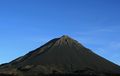
Main ash cone of Pico do Fogo
3-D image of the island of Fogo from NNE
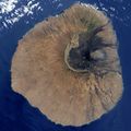
Natural colour satellite image of Fogo
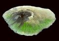
Chã das Caldeiras and main ash cone, Fogo. NASA satellite image, 2009
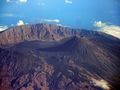
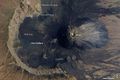
Aerial shot
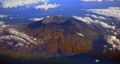
Aerial shot

Losma, an endemic medicinal plant


المراجع
- ^ أ ب ت ث ج ح خ Cabo Verde, Statistical Yearbook 2015, Instituto Nacional de Estatística
- ^ "Island boulders reveal ancient mega-tsunami". Retrieved 2015-10-06.
- ^ "Insulae Capitis Viridis" (in اللاتينية). 1598.
- ^ Centre historique de São Filipe, UNESCO
- ^ أ ب ت S. F. Jenkins; et al. (20 March 2017). "Damage from lava flows: insights from the 2014–2015 eruption of Fogo, Cape Verde". Journal of Applied Volcanology Society and Volcanoes. 6.
- ^ Cape Verde History Timeline, WorldAtlas
- ^ History of Mosteiros (البرتغالية)
- ^ Lei nº 23/IV/91, p. 43
- ^ Lei nº 66/VI/2005, p. 52
- ^ أ ب "Volcano area, Ilha do Fogo". Important Bird Areas factsheet. BirdLife International. 2018. Retrieved 2018-08-07.
- ^ "Echium vulcanorum". The IUCN Red List of Threatened Species. IUCN. 3.1. 2017. Retrieved August 7, 2018.
- ^ "Erysimum caboverdeanum". The IUCN Red List of Threatened Species. IUCN. 3.1. 2017. Retrieved August 7, 2018.
- ^ أ ب ت Roberts, Edmund (1837). Embassy to the Eastern Courts of Cochin-China, Siam, and Muscat. New York: Harper & Brothers. p. 14.
- ^ "Climate São Filipe". Retrieved 7 October 2018.
- ^ "Climate Chã das Caldeiras". Retrieved 7 October 2018.
- ^ أ ب ت ث ج ح خ Source: Statoids
- ^ 2010 Census Summary
- ^ Fogo coffee
- ^ Cabo Verde Fast Ferry's website
- ^ Ilha do Fogo, Rede rodoviária, Instituto de Estradas
وصلات خارجية
- Informations and impressions from Fogo
- Caboverde.com
- University of Massachusetts – information and images from Fogo