غيرسون
گرهسون أو غيرِسون (Giresun ؛ تُنطق [ɡiɾeˈsun]) هي عاصمة محافظة گرهسون في شمال شرق تركيا على ساحل البحر الأسود ويبلغ تعداد سكانها حوالي 83,636 نسمة.
Giresun | |
|---|---|
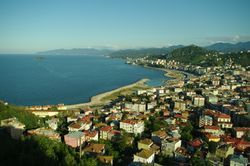
 General view of eastern part of Giresun city | |
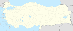
| الإحداثيات: 40°54′55″N 38°23′22″E / 40.91528°N 38.38944°ECoordinates: 40°54′55″N 38°23′22″E / 40.91528°N 38.38944°E | |
| Country | Turkey |
| Province | Giresun |
| الحكومة | |
| • Mayor | Kerim Aksu (CHP) |
| المساحة | |
| • District | 295٫71 كم² (114٫17 ميل²) |
| التعداد (2012)[2] | |
| • Urban | 100٬712 |
| • District | 123٬129 |
| • كثافة District | 420/km2 (1٬100/sq mi) |
| Climate | Cfa |
| الموقع الإلكتروني | www.giresun.bel.tr |
. . . . . . . . . . . . . . . . . . . . . . . . . . . . . . . . . . . . . . . . . . . . . . . . . . . . . . . . . . . . . . . . . . . . . . . . . . . . . . . . . . . . . . . . . . . . . . . . . . . . . . . . . . . . . . . . . . . . . . . . . . . . . . . . . . . . . . . . . . . . . . . . . . . . . . . . . . . . . . . . . . . . . . . .
أصل الاسم
Giresun was known to the ancient Greeks as Choerades or more prominently as Kerasous or Cerasus (باليونانية قديمة: Κερασοῦς), the origin of the modern name.
Pre-Greek and Greek linguist Robert S. P. Beekes has stated that the name Kerasous corresponds to κερασός (kerasós) "cherry" + -ουντ (a place marker).[3] Thus, he notes that the Greek root of the word "cherry", κερασός (kerasós), predates the name of the city,[3] Beekes holds that the ultimate origin of the word cherry (and thus the name of the city) is from a Pre-Greek substrate, likely of Anatolian origin, given the intervocalic σ in Κερασοῦς and the apparent cognates of it found in other languages the region.[3]
Pharnaces I of Pontus renamed the city Pharnacia after himself after he captured the city in 183 BCE, and it was called by that name as late as the 2nd century CE. According to A. H. M. Jones, the city officially reverted to its original name, Kerasous, in 64 CE.[4] Whatever the etymology, the Greek name Kerasous was Turkified into Giresun after Turks gained permanent control of the region in the late 15th century.
المناخ
The water temperature is cool in winter and warm in summer and fluctuates between 8° and 29 °C throughout the year.
| بيانات مناخ Giresun | |||||||||||||
|---|---|---|---|---|---|---|---|---|---|---|---|---|---|
| الشهر | يناير | فبراير | مارس | أبريل | مايو | يونيو | يوليو | أغسطس | سبتمبر | اكتوبر | نوفمبر | ديسمبر | العام |
| العظمى القياسية °س (°ف) | 24.9 (76.8) |
29.5 (85.1) |
34.9 (94.8) |
36.0 (96.8) |
35.4 (95.7) |
36.2 (97.2) |
35.3 (95.5) |
35.2 (95.4) |
32.8 (91) |
37.3 (99.1) |
32.8 (91) |
28.0 (82.4) |
37٫3 (99٫1) |
| العظمى المتوسطة °س (°ف) | 10.6 (51.1) |
10.7 (51.3) |
11.7 (53.1) |
15.1 (59.2) |
18.8 (65.8) |
23.4 (74.1) |
26.1 (79) |
26.5 (79.7) |
23.6 (74.5) |
19.7 (67.5) |
16.1 (61) |
12.9 (55.2) |
17٫93 (64٫28) |
| المتوسط اليومي °س (°ف) | 7.3 (45.1) |
7.2 (45) |
8.1 (46.6) |
11.4 (52.5) |
15.5 (59.9) |
20.0 (68) |
22.7 (72.9) |
23.0 (73.4) |
20.0 (68) |
16.2 (61.2) |
12.5 (54.5) |
9.5 (49.1) |
14٫45 (58٫01) |
| الصغرى المتوسطة °س (°ف) | 4.7 (40.5) |
4.4 (39.9) |
5.3 (41.5) |
8.6 (47.5) |
12.7 (54.9) |
16.9 (62.4) |
19.8 (67.6) |
20.1 (68.2) |
17.2 (63) |
13.6 (56.5) |
9.9 (49.8) |
6.8 (44.2) |
11٫67 (53) |
| الصغرى القياسية °س (°ف) | -6.2 (20.8) |
-9.8 (14.4) |
-4.0 (24.8) |
-1.4 (29.5) |
4.0 (39.2) |
6.8 (44.2) |
12.1 (53.8) |
12.1 (53.8) |
4.8 (40.6) |
4.3 (39.7) |
-4.7 (23.5) |
-2.4 (27.7) |
−9٫8 (14٫4) |
| هطول mm (inches) | 122.1 (4.807) |
97.7 (3.846) |
91.3 (3.594) |
77.3 (3.043) |
69.9 (2.752) |
78.0 (3.071) |
75.9 (2.988) |
88.4 (3.48) |
126.0 (4.961) |
167.0 (6.575) |
148.0 (5.827) |
124.4 (4.898) |
1٬266 (49٫843) |
| Avg. rainy days | 14.8 | 14.2 | 16.2 | 15.5 | 14.6 | 11.9 | 10.6 | 10.8 | 12.8 | 14.4 | 13.6 | 14.4 | 163٫8 |
| Sunshine hours | 74.4 | 86.8 | 86.8 | 114 | 164.3 | 192 | 186 | 139.5 | 114 | 105.4 | 96 | 58.9 | 1٬418٫1 |
| Source: Turkish State Meteorological Service [5] | |||||||||||||
التاريخ
الاقتصاد
Historically, Giresun was known for producing hazelnut. As of 1920, hazelnuts covered 460 square miles of the area. [6] Manganese mines were also in the area, producing 470 tons as of 1901.[7]
المعالم
- قلعة گرهسون، المحفوظة جيداً، في وسط المدينة.
- جزيرة گرهسون
- مسجد حاجي حسين، مسجد قلعه، قبر سيدي وقاص، ضريح طوپال عثمان
- Old Ottoman houses of Zeytinlik district
- Highlands (Kümbet, Bektaş, Kulakkaya, Çakrak, Tohumluk, Kurtbeli, Kazıkbeli, Ayıbeli, Beytarla, Buları, Kırkharman)
العلاقات الدولية
. . . . . . . . . . . . . . . . . . . . . . . . . . . . . . . . . . . . . . . . . . . . . . . . . . . . . . . . . . . . . . . . . . . . . . . . . . . . . . . . . . . . . . . . . . . . . . . . . . . . . . . . . . . . . . . . . . . . . . . . . . . . . . . . . . . . . . . . . . . . . . . . . . . . . . . . . . . . . . . . . . . . . . . .
البلدات التوأم والمدن الشقيقة
جيرسون متوأمة مع:
- Sagae, محافظة ياماگاتا، اليابان [8] (منذ 25 يونيو 1988)
- شكي، أذربيجان (منذ 12 مارس 2001)
الهامش
- ^ "Area of regions (including lakes), km²". Regional Statistics Database. Turkish Statistical Institute. 2002. Retrieved 2013-03-05.
- ^ "Population of province/district centers and towns/villages by districts - 2012". Address Based Population Registration System (ABPRS) Database. Turkish Statistical Institute. Retrieved 2013-02-27.
- ^ أ ب ت Robert S. P. Beekes (2010). Etymological Dictionary of Greek. Brill. ISBN 978-90-04-17418-4.
As the improved cherry came from the Pontos area (cf. Κερασοῦς "rich in cherries", town on the Pontos), the name is probably Anatolian as well. Given its intervocalic σ, the form must be Anatolian or Pre-Greek. For the suffix, cf. ▶-θíασος, ▶-κάρπασος, which too are of foreign origin. Assyr. karšu has also been adduced. Cf. on ▶κράνον 'cornelian cherry'. Gr. κέρασος, -íα, κεράσιον were borrowed into many languages: Asiatic names of the cherry-tree and the cherry, like Arm. ker̄as, Kurd. ghilas, and in the West, Lat. cerasus, -ium, VLat. ★cerasia, ★ceresia, -ea; from Latin came the Romance and Germanic forms like MoFr. cerise, OHG chirsa > Kirsche. Lit.: Olck in PW 11: 509f. and Hester Lingua 13 (1965): 356.
- ^ Arrian: Periplus Ponti Euxini, edited and translated by Aidan Liddle (London: Bristol Classical Press, 2003), p. 117
- ^ "Giresun". Turkish State Meteorological Service. Retrieved 1 September 2016.
- ^ Prothero, W.G. (1920). Armenia and Kurdistan. London: H.M. Stationery Office. p. 61.
- ^ Prothero, W.G. (1920). Armenia and Kurdistan. London: H.M. Stationery Office. p. 73.
- ^ "International Exchange". List of Affiliation Partners within Prefectures. Council of Local Authorities for International Relations (CLAIR). Retrieved 21 November 2015.
- The Byzantine Monuments and Topgraphy of the Pontos by A. Bryer and D. Winfield
- The Encyclopaedia of Pontian Hellenism.

