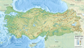
سلسلة جبال تحتلي
سلسلة جبال تحتلي (تركية: Tahtalı Dağları؛ إنگليزية: Tahtalı Mountain Range) تقع في وسط الأناضول في تركيا. وتقع في وسط جبال طوروس، أغلبها بين محافظات قيصري، أضنة، مع أجزاء صغيرة تمتد في محافظتي سيڤاس وكهرمانمراش.
| سلسلة جبال تحتلي | |
|---|---|
 جبال تحتلي، في وسط الأناضول | |
| أعلى نقطة | |
| القمة | بـِيْ داغي |
| الارتفاع | 3,075 m (10,089 ft) |
| الإحداثيات | 38°50′0″N 36°27′0″E / 38.83333°N 36.45000°ECoordinates: 38°50′0″N 36°27′0″E / 38.83333°N 36.45000°E |
| الجغرافيا | |
| البلد | تركيا |
| السلسلة الأم | جبال طوروس |
The mountain range is location to the southeast of Kayseri province, south of Siva, north of Adana and northwest of Kahramanmaraş. The Tahtalı mountain range is between the two branches of the river Seyhan, as well as between Zamantı and Göksu. The sources of both branches are also the northern tip of Tahtalı which meet the river Seyhan at the southern tip.
The Tahtalı Mountain range is about 170 km long and 50 km wide. Many mountains in this range have elevations of over 2500 m. أعلى الجبال هو (بـِيْ داغي) near طوفانبـِيْلي (Adana Province) with an elevation 3075 meters. نهرا جيحان و سيحان ينبعان من تلك الجبال وينسابان متوازيان لبعضهما البعض ويصبان بالقرب من چكروڤا، في البحر المتوسط.
. . . . . . . . . . . . . . . . . . . . . . . . . . . . . . . . . . . . . . . . . . . . . . . . . . . . . . . . . . . . . . . . . . . . . . . . . . . . . . . . . . . . . . . . . . . . . . . . . . . . . . . . . . . . . . . . . . . . . . . . . . . . . . . . . . . . . . . . . . . . . . . . . . . . . . . . . . . . . . . . . . . . . . . .
الهامش
- "Sea to Sky, Olympos Cable Car." Cable Car. OLYMPOS TELEFERIK, n.d. Web.
