سميساط
سميساط أو سميسط (باليونانية قديمة: Σαμόσατα ساموساتا، بالسريانية: ܫܡܝܫܛ؛ بالأرمنية: Շամուշատ) مدينة قديمة من مدن الأناضول تقع غربي نهر الفرات جنوبي ملطية وشرقي مرعش عندها ينعطف نهر الفرات إلى الغرب. كانت من الثغور الجزرية ومنها تخرج الجيوش الإسلامية إلى بلاد الروم.[1]
سميساط
Samsat | |
|---|---|
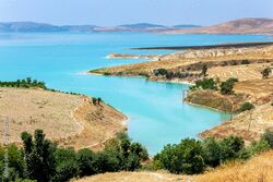
 سد أتاتورك، ضمن مشروع جنوب شرق الأناضول، بالقرب من سميساط. | |
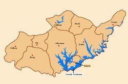
 أقضية محافظة أدييمن | |
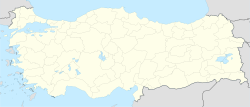
| الإحداثيات: 37°34′46.4″N 38°28′52.7″E / 37.579556°N 38.481306°ECoordinates: 37°34′46.4″N 38°28′52.7″E / 37.579556°N 38.481306°E | |
| البلد | |
| المحافظة | محافظة أدييمن |
| الحكومة | |
| • Mayor | Halil Fırat (AKP) |
| • Kaymakam | Halid Yıldız |
| المساحة | |
| • الإجمالي | 338 كم² (131 ميل²) |
| المنسوب | 610 m (2٬000 ft) |
| التعداد | |
| • الإجمالي | 3٬789 |
| منطقة التوقيت | UTC+03:00 (Turkey Time) |
| الموقع الإلكتروني | http://www.samsat.gov.tr |
Halil Fırat from the Justice and Development Party (AKP) was elected mayor in the local elections in March 2019.[2] The current Kaymakam is Halid Yıldız.[3]
Samsat was the ancient capital of Kingdom of Commagene. The current site of Samsat is comparatively new, however, being rebuilt in 1989 when the old town of Samosata was flooded during the construction of the Atatürk Dam.[4] The reconstruction process has not yet been fully completed.[5] An ancient tell nearby dating back to the paleolithic era has survived to the current day.
In 2016, the town had a population of 3,789,[6] down from 4,720 in 2008 and a peak of 6,917 in 2000.
. . . . . . . . . . . . . . . . . . . . . . . . . . . . . . . . . . . . . . . . . . . . . . . . . . . . . . . . . . . . . . . . . . . . . . . . . . . . . . . . . . . . . . . . . . . . . . . . . . . . . . . . . . . . . . . . . . . . . . . . . . . . . . . . . . . . . . . . . . . . . . . . . . . . . . . . . . . . . . . . . . . . . . . .
الاسم
كانت البلدة مركز لمملكة حيثية في العصر الحديدي وكان اسمها كـُمّوح Kummuh في تلك الفترة.[7]
By the Hellenistic Period, the Greeks and Romans knew the city as Samosata (باليونانية قديمة: Σαμόσατα) or Samosate.[8][9]
The most commonly accepted origin of the name suggests that ancient Samosata was so named in honour of Sames I, an Orontid king of Armenia and Sophene who ruled around 260 BC.[10][11][12][13]
التاريخ
القِدم
| الوجه: الرأس المكلل لـهادريان | الظهر: داخل إكليل: |
| عملة برونزية صكها هادريان في ساموستا 117-138; ref.: BMC 22 | |
المنطقة فتحها سرگون الثاني في 708 ق.م. وأصبحت مقاطعة في آشور.[7]
Control of the region of Commagene was apparently held by the Orontid dynasty from the 3rd century BC, who also ruled over Armenia and Sophene. These seem to have held Commagene continuously from the time of Sames I, as the later kings of Commagene of the 2nd century BC traced their lineage back to them.[14]
الملك أنطيوخوس الثالث was the last effective ruler,[15] and his death caused a political crisis of succession into which Rome intervened in 72 AD.[16]
It was at Samosata that Julian II had ships made in his expedition against شاپور الثاني, and it was a natural crossing-place in the struggle between Heraclius and Chosroes in the 7th century.
كانت سميساط مسقط رأس العديد من المشاهير منذ القِدم، أمثال لوقيان (حوالي 120-192) وپولس من سميساط (ازدهر 260).
العصور الوسطى
استولى العرب على كوماگنى وسيطروا على سميساط من البيزنطيين في 640. توفي صفوان بن المعطل ودُفِن في سميساط. وفي يونيو 966، كانت سميساط موقع تبادل للأسرى بين الامبراطور البيزنطي نقفور الثاني فوكاس وعدوه المسلم سيف الدولة الهمزاني.[17]
وفي القرن العاشر الميلادي، وُلِد فيها الشمشاطي الشاعر العربية الموصلي الشهير.
في فبراير 1098، هوجم الأمير بلدوخ (Bulduk) من الأسرة الأرتقية، من قِبل بودوان من أنطاكية، الذي فرّق جيش بلدوخ. وفي 1114 كانت واحدة من أكثر معاقل المسلمين عداءً لـكونت الرها، التي استسلمت له، إلا أن المسلمين استردوها حوالي 1149.
كان القرن 13 مدمراً للبلدة. Rüknettin Süleyman II of the Anatolian Seljuks captured Samosata in 1203, and it was looted in 1237 by the Harzemşah. Then it was invaded by the Mongol Emperor Hülagü Khan in 1240 and later also by the Dulkadiroğulları.
It was temporarily absorbed into the Ottoman Empire by Yıldırım Beyazıt in 1392 and in 1401 it was destroyed by Timur. In 1516, the ottoman Sultan Selim I recaptured it for the Ottomans who renamed it Samsat. It lost its old importance in the Ottoman administration and became the centre of a sanjak.
في العصور الحديثة
During Turkey's republican period, the population of the town was decreasing. In 1960, Samsat was transformed into a district center and connected to the province of Adıyaman.
The city of Samsat was evacuated from the old settlement on 5 March 1988 due to the construction of the Atatürk Dam. A new location for the settlement was announced through the law No. 3433 dated 21 April 1988. The historical Samsat was submerged in 1989 as the Atatürk Dam was filled with the water of the Euphrates river. The new town was built beside the new waterline by the Turkish government to house the displaced residents.
في المسيحية
In the Christian martyrology, seven Christian martyrs were crucified in 297 in Samosata for refusing to perform a pagan rite in celebration of the victory of Maximian over the Sassanids: Abibus, Hipparchus, James, Lollian, Paragnus, Philotheus, and Romanus. Saint Daniel the Stylite was born in a village near Samosata; Saint Rabbulas, venerated on 19 February, who lived in the 6th century at Constantinople, was also a native of Samosata. A Notitia Episcopatuum of Antioch in the 6th century mentions Samosata as an autocephalous metropolis (Échos d'Orient, X, 144); at the synod that reinstated Patriarch Photius I of Constantinople (the Photian Council) of 879, the See of Samosata had already been united to that of Amida (Diyarbakır).[18] As in 586, the titular of Amida bears only this title ([19]), it must be concluded that the union took place between the 7th and the 9th centuries. Earlier bishops included Peperius, who attended the Council of Nicaea (325); Saint Eusebius of Samosata, a great opponent of the Arians, killed by an Arian woman (c. 380), honoured on 22 June; Andrew, a vigorous opponent of Cyril of Alexandria and of the Council of Ephesus.[20]
Chabot gives a list of twenty-eight Syrian Miaphysite bishops.[21] The Syrian bishopric probably lapsed in the 12th century.[22] Samosata is included in the Catholic Church's list of titular sees, but no further titular bishops have been appointed for that eastern see since the Second Vatican Council.
. . . . . . . . . . . . . . . . . . . . . . . . . . . . . . . . . . . . . . . . . . . . . . . . . . . . . . . . . . . . . . . . . . . . . . . . . . . . . . . . . . . . . . . . . . . . . . . . . . . . . . . . . . . . . . . . . . . . . . . . . . . . . . . . . . . . . . . . . . . . . . . . . . . . . . . . . . . . . . . . . . . . . . . .
الآثار
Samsat Höyük is a tell located just north of the Samsat district of Adıyaman. Archaeological research on the hill of Şehremuz in Samsat has uncovered relics from the 7000 BC Paleolithic era; the 5000 BC Neolithic, 3000 BC Chalcolithic and 3000 to 1200 BC Bronze Ages. The ancient city of Ḫaḫḫum (Hittite: Ḫaḫḫa) was located nearby; it is recorded as a source of gold for ancient Sumeria.
The first excavations were conducted in 1964 and 1967 under the direction of T. Goell. In fact, the settlement was known and famous before these excavations. Then, in 1977, under the Lower Euphrates Project, plans were put together aimed at identifying and saving the archaeological settlements that were to be inundated by the reservoir of Karakaya and Atatürk Dams. Surface surveys were conducted under the direction of Mehmet Özdoğan. In these studies, it was concluded that the settlement was permanently inhabited from the Halaf Period to the Ottoman Period. The following year, the excavations started in 1978, except for 1980, until 1987, under Ankara University, Faculty of Language and History-Geography It was conducted by the team led by Nimet Özgüç. These excavations were carried out on a very wide area, including the lower city and surrounding walls.
Coins belonging to the 12th - 13th centuries AD were identified during the excavations in the layers dating to the late phases of the Middle Ages. Of these Seljuk sultans I. Gıyaseddin Keyhusrev (1192-1195), Ala al-Din Keykubbad, (1219-1236), II. Gıyaseddin Keyhusrev (1236-1246), IV. Rükn el-Din The coins of Kılıç Arslan (1257-1264), as well as the coins of Saladin (1170-1193) printed in Harran, were uncovered.[23]
The collection of glassware with cups, glasses and bowls is very rich. Other finds include oil lamps, ivory comb, fragrance bottle,[24] terracotta lamps, bone spoons, leaf-shaped marble sconces and coins.[25]
The walls of the Seljuk Period, built on a solid Byzantine fortress, were preserved intact. The inscription on the limestone of this fortification was studied by a master calligrapher. The landfill belonged to Diyarbekr Şah Karaaslan.[26]
The centre of the palace, which is thought to be the central courtyard, is 14,65 X 20,55 meters and it has a mosaic corner.[27]
The skeletons of five people thrown into a 1.8 meter diameter well of the Islamic Period were found. At the bottom with the skeletons, five gold coins and silver coins from the Abbasid Period were found. One of the gold coins belongs to Harun al-Rashid (766 - 709) and the others to Mutawakkil (822 - 861).[28]
Today the settlement is under the Euphrates but before inundation it was 37–40 meters above the plain level and had an area of 500 x 350 meters. The steepest slope is the eastern slope and the lowest slope is the southwest-facing slope. The mound consists of a terrace and a ruined town covered with sediment.[29] Samsat Höyük as an archaeological site is considered to no longer accessible while it is covered by the waters of the reservoir. The old town of Samosata below the tell was not excavated.[30]
الجغرافيا
The new Samsat district is a peninsula surrounded on the three sides by the Atatürk Reservoir. The distance from the sea to the city centre is 470 km. The district is a plain that descends to the south.
In the hot summers and dry winters, while the Mediterranean climate is warm and rainy, it is similar to the South East Anatolian climate due to the low relative humidity. However, due to the influence of the Atatürk Reservoir in recent years, humidity has increased relatively.
سامسات الحالية
سميساط القديمة مازالت ماثلة حتى يومنا هذا كبلدة سامسات التركية. بلدة سميساط القديمة غمرتها المياه في 1989 خلف سد أتاتورك. وقد بُنيت بلدة جديدة بنفس الاسم للسكان المرحـّلين لغرق بلدتهم القديمة. سامسات المعاصرة هي بلدة بتعداد سكان يناهز 2000 نسمة. وهي عاصمة قضاء بنفس الاسم في المحافظة التركية أدييمن.
المراجع
- ^ "موسوعة الشام Sheet". Retrieved 2010-8-8.
{{cite web}}: Check date values in:|accessdate=(help) - ^ "Adıyaman Samsat Seçim Sonuçları - 31 Mart 2019 Yerel Seçimleri". www.sabah.com.tr. Retrieved 2019-12-18.
- ^ "T.C. Samsat Kaymakamlığı". www.samsat.gov.tr. Retrieved 2019-12-18.
- ^ Samsat, Gezilecek Yerler.
- ^ Samsat’ta kalıcı konutların temelleri atılıyor.
- ^ "2016 genel nüfus sayımı verileri" (html) (Doğrudan bir kaynak olmayıp ilgili veriye ulaşmak için sorgulama yapılmalıdır). Türkiye İstatistik Kurumu. Erişim tarihi: 7 Mart 2017.
- ^ أ ب Michael Blömer / Religious Life of Commagene in the Late Hellenistic and Early Roman Period pp.95-129/The Letter of Mara bar Sarapion in Context. Proceedings of the Symposium Held at Utrecht University, 10–12 December 2009 /BRILL 2012
In doing so, Samosata, the Commagenian capital and hometown of Mara bar Sarapion, would suit best as the prime object of investigation. The place was one of the most important sites along the Upper Euphrates. It offered an easy crossing of the river and was occupied since Chalcolithic times. It is named Kummuḫ in Iron Age sources and was the centre of an eponymous independent Syro-Hittite kingdom from the 12th to the 8th century BC. The Assyrian king Sargon II conquered Kummuḫ in 708 BC, but it remained an important provincial town during late Iron Age. In Hellenistic times it was capital of the kingdom of Commagene. The city was renamed Samosata by a predecessor of the Commagenian royal family, the Armenian king Samos I, in the 3rd century BCE. After the Roman occupation in CE 72, Samosata prospered as a major commercial, cultural and military centre of the Roman province of Syria.
- ^ The Princeton Encyclopedia of Classical Sites, SAMOSATA (Sainsat) SW Anatolia.
- ^ Prof. Dr. Gönül Öney, 1978 – 79 ve 1981 Yılı Samsat Kazılarında Bulunan İslam Devri Buluntularıyla İlgili İlk Haber Sh.: 71
- ^ Toumanoff, Cyril Studies in Christian Caucasian History (1963), p. 280 and 292, Georgetown University Press
- ^ Nemrud Dağı Text, Theresa Goell, Donald Hugo Sanders, ed. Eisenbrauns, 1996, p. 367 "Puchstein's epigraphic interpretation was not unambiguous; the name of the father could be read or restored to Samos (Sames) or Arsames. Puchstein had decided to read Samos; Honigmann (1963: 981) decided likewise to read Samos; Reinach and" ... "Samos was the "founder" of Samosata in the same way that his son Arsames was "founder" of Arsameia ", p.368 "Chronologically, this king Samos belongs to the first half of the third century B.C.E." [1]
- ^ M. J. Versluys/ Visual Style and Constructing Identity in the Hellenistic World: Nemrud Dag and Commagene under Antiochos I/Cambridge University Press, 2017 г.—pp.48 (312) ISBN 1107141974, 9781107141971
We know nothing about the status of Commagene under Seleucid rule. The Armenian king Samos I is believed to have founded Samosata, later the capital of Commagene, in the middle of the third century BC. The second century BC saw the rise of the two powers that would play an important role in Commagene's future during the next centuries: Rome and Parthia. Their growing prominence, combined with the failing of the central Seleucid power, resulted in the rise of several small monarchies, of which Commagene was one. Other independent kingdoms that came into being around this time include Pergamon, Pontos, Baktria, Parthia, Armenia, Iudea and Nabatea. Diodorus tells us that a Seleucid epistates named Ptolemy rose to power in Commagene in 163 BC. Most scholars assume that Ptolemy was the first Commagenean king and that he descended from the Armenian Orontids. We know virtually nothing about the following decades. Samos II took power around 130 BC, as is concluded from some coins that have been preserved, showing a portrait with the inscription “king Samos.”
- ^ Not to be confused with a later Sames/Samos (Sames II), who ruled Commagene in the second century BCE
- ^ Brijder, Herman (2014). Nemrud Dagi: recent archaeological research and conservation activities in the tomb sanctuary on Mount Nemrud. ISBN 9781614519058.
- ^ Chahin, Mark (2001). The Kingdom of Armenia. Routledge. pp. 190–191. ISBN 0-7007-1452-9.
- ^ Tacitus, The Annals 2.42.
- ^ Fattori 2013, p. 117.
- ^ Mansi, Conciliorum collectio, XVII-XVIII, 445.
- ^ Le Quien, Oriens christianus, II, 994.
- ^ Le Quien, Oriens christianus, II, 933-6.
- ^ Revue de l'Orient chrétien, VI, 203.
- ^ Fiey, J. M. (1993), Pour un Oriens Christianus novus; répertoire des diocèses Syriaques orientaux et occidentaux, Beirut, p. 263, ISBN 3-515-05718-8
- ^ Nimet Özgüç, 1985 Yılında Yapılmış Olan Samsat Kazılarının Sonuçları' – 8. Kazı Sonuçları Toplantısı (1986) Sh.: 297
- ^ Nimet Özgüç, 8. Kazı Sonuçları Toplantısı, p298
- ^ Nimet Özgüç, 7. Kazı Sonuçları Toplantısı, p 227
- ^ Nimet Özgüç, Samsat Kazıları 1982' – 5. Kazı Sonuçları Toplantısı (1983) p111.
- ^ Nimet Özgüç, Samsat 1984 Yılı Kazıları, 7. Kazı Sonuçları Toplantısı (1985) p224.
- ^ Nimet Özgüç, 7. Kazı Sonuçları Toplantısı (1985) Sh.: 226
- ^ TAY – Yerleşme Ayrıntıları.
- ^ Samsat.
