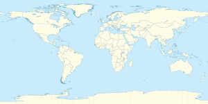
خط العرض 22° شمالاً

خط العرض 22 شمالًا (إنگليزية: 22th parallel north) هي دائرة عرض بزاوية 22 درجة شمال خط الاستواء. تمر دائرة العرض 22° شمالاً عبر أفريقيا، المحيط الهندي، آسيا، المحيط الهادي، أمريكا الوسطى، منطقة البحر الكاريبي والمحيط الأطلسي.

Line across the Earth
22°
خط العرض 22nd شمال
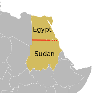
في أفريقيا, the parallel defines most of the border between Egypt and Sudan. The eastern part of the border is disputed.


تتبع غالبية الحدود بين مصر والسودان خط الموازي..[1]

عند خط العرض هذا، تكون الشمس مرئية لمدة 13 ساعة و29 دقيقة أثناء الانقلاب الصيفي، و10 ساعة و47 دقيقة أثناء الانقلاب الشتوي.[2]

. . . . . . . . . . . . . . . . . . . . . . . . . . . . . . . . . . . . . . . . . . . . . . . . . . . . . . . . . . . . . . . . . . . . . . . . . . . . . . . . . . . . . . . . . . . . . . . . . . . . . . . . . . . . . . . . . . . . . . . . . . . . . . . . . . . . . . . . . . . . . . . . . . . . . . . . . . . . . . . . . . . . . . . .

حول العالم

بدءاً من خط الزوال الرئيسي، في الاتجاه الشرقي، يمر خط العرض 22° شمالاً عبر:

الإحداثيات البلد أو الإقليم أو البحر ملاحظات
22°0′N 0°0′E / 22.000°N 0.000°E / 22.000; 0.000 (Prime Meridian)   الجزائر
22°0′N 9°21′E / 22.000°N 9.350°E / 22.000; 9.350 (Niger)   نيجر
22°0′N 15°11′E / 22.000°N 15.183°E / 22.000; 15.183 (Chad)   تشاد
22°0′N 19°4′E / 22.000°N 19.067°E / 22.000; 19.067 (Libya)   ليبيا
22°0′N 25°0′E / 22.000°N 25.000°E / 22.000; 25.000 (Egypt / Sudan border)   مصر /   السودان border
22°0′N 31°19′E / 22.000°N 31.317°E / 22.000; 31.317 (Sudan)   السودان The border diverts north at Lake Nasser, enclosing the Wadi Halfa Salient - as it passes through the lake, the parallel is entirely within Sudan
22°0′N 31°24′E / 22.000°N 31.400°E / 22.000; 31.400 (Egypt / Sudan border)   مصر /   السودان border
22°0′N 33°10′E / 22.000°N 33.167°E / 22.000; 33.167 (Egypt / Bir Tawil border)   مصر / Bir Tawil border Bir Tawil is not claimed by any country.
22°0′N 34°5′E / 22.000°N 34.083°E / 22.000; 34.083 (Hala'ib Triangle / Sudan border) Hala'ib Triangle /   السودان border The Hala'ib Triangle is a disputed territory claimed by both Egypt and Sudan - Egypt controls the territory.
22°0′N 36°52′E / 22.000°N 36.867°E / 22.000; 36.867 (Red Sea) Red Sea
22°0′N 38°56′E / 22.000°N 38.933°E / 22.000; 38.933 (Saudi Arabia)   السعودية
22°0′N 55°40′E / 22.000°N 55.667°E / 22.000; 55.667 (Oman)   عُمان
22°0′N 59°39′E / 22.000°N 59.650°E / 22.000; 59.650 (Indian Ocean) Indian Ocean Arabian Sea
22°0′N 69°10′E / 22.000°N 69.167°E / 22.000; 69.167 (India)   الهند Gujarat - Kathiawar Peninsula
22°0′N 72°14′E / 22.000°N 72.233°E / 22.000; 72.233 (Indian Ocean) Indian Ocean Gulf of Khambhat
22°0′N 72°30′E / 22.000°N 72.500°E / 22.000; 72.500 (India)   الهند Gujarat
Madhya Pradesh
Chhattisgarh
Orissa
West Bengal
22°0′N 89°5′E / 22.000°N 89.083°E / 22.000; 89.083 (Bangladesh)   بنگلادش Several islands in the Ganges Delta
22°0′N 90°41′E / 22.000°N 90.683°E / 22.000; 90.683 (Indian Ocean) Indian Ocean Bay of Bengal
22°0′N 91°53′E / 22.000°N 91.883°E / 22.000; 91.883 (Bangladesh)   بنگلادش
22°0′N 92°36′E / 22.000°N 92.600°E / 22.000; 92.600 (India)   الهند For about 3 km
22°0′N 92°38′E / 22.000°N 92.633°E / 22.000; 92.633 (Myanmar)   ميانمار (Burma)
22°0′N 92°53′E / 22.000°N 92.883°E / 22.000; 92.883 (India)   الهند For about 4 km
22°0′N 92°56′E / 22.000°N 92.933°E / 22.000; 92.933 (Myanmar)   ميانمار (Burma) For about 5 km
22°0′N 92°58′E / 22.000°N 92.967°E / 22.000; 92.967 (India)   الهند For about 3 km
22°0′N 93°0′E / 22.000°N 93.000°E / 22.000; 93.000 (Myanmar)   ميانمار (Burma)
22°0′N 99°59′E / 22.000°N 99.983°E / 22.000; 99.983 (China)   الصين Yunnan - passing just north of Jinghong, Xishuangbanna Dai Autonomous Prefecture
22°0′N 101°37′E / 22.000°N 101.617°E / 22.000; 101.617 (Laos)   لاوس
22°0′N 102°29′E / 22.000°N 102.483°E / 22.000; 102.483 (Vietnam)   ڤيتنام
22°0′N 106°41′E / 22.000°N 106.683°E / 22.000; 106.683 (China)   الصين Guangxi (for about 4 km)
22°0′N 106°44′E / 22.000°N 106.733°E / 22.000; 106.733 (Vietnam)   ڤيتنام For about 6 km
22°0′N 106°48′E / 22.000°N 106.800°E / 22.000; 106.800 (China)   الصين Guangxi and Guangdong
22°0′N 113°22′E / 22.000°N 113.367°E / 22.000; 113.367 (South China Sea) South China Sea
22°0′N 113°44′E / 22.000°N 113.733°E / 22.000; 113.733 (China)   مكاو Passing through islands in the Wanshan Archipelago (Guangdong), about 12 km south of Macau
22°0′N 113°50′E / 22.000°N 113.833°E / 22.000; 113.833 (South China Sea) South China Sea
22°0′N 114°8′E / 22.000°N 114.133°E / 22.000; 114.133 (China)   هونگ كونگ More islands in the Wanshan Archipelago (Guangdong), about 20 km south of Hong Kong
22°0′N 114°13′E / 22.000°N 114.217°E / 22.000; 114.217 (South China Sea) South China Sea
22°0′N 120°41′E / 22.000°N 120.683°E / 22.000; 120.683 (Taiwan)   تايوان
(Taiwan)
Passing through Hengchun and Kenting
22°0′N 120°52′E / 22.000°N 120.867°E / 22.000; 120.867 (Pacific Ocean) Pacific Ocean Passing just south of Orchid Island,   تايوان
22°0′N 160°6′W / 22.000°N 160.100°W / 22.000; -160.100 (United States)   الولايات المتحدة Island of Niihau, Hawaii
22°0′N 160°3′W / 22.000°N 160.050°W / 22.000; -160.050 (Pacific Ocean) Pacific Ocean
22°0′N 159°46′W / 22.000°N 159.767°W / 22.000; -159.767 (United States)   الولايات المتحدة Island of Kauai, Hawaii - passing just north of Lihue
22°0′N 159°21′W / 22.000°N 159.350°W / 22.000; -159.350 (Pacific Ocean) Pacific Ocean Passing just north of the island of San Juanito,   المكسيك
22°0′N 105°39′W / 22.000°N 105.650°W / 22.000; -105.650 (Mexico)   المكسيك Passing 8 km north of Aguascalientes
22°0′N 97°43′W / 22.000°N 97.717°W / 22.000; -97.717 (Gulf of Mexico) Gulf of Mexico
22°0′N 84°36′W / 22.000°N 84.600°W / 22.000; -84.600 (Cuba)   كوبا
22°0′N 84°0′W / 22.000°N 84.000°W / 22.000; -84.000 (Caribbean Sea) Caribbean Sea Gulf of Batabanó - passing just north of Isla de la Juventud,   كوبا
Gulf of Cazones - passing just south of the Zapata Peninsula,   كوبا
22°0′N 80°23′W / 22.000°N 80.383°W / 22.000; -80.383 (Cuba)   كوبا Passing 3 km north of Sancti Spíritus
22°0′N 77°38′W / 22.000°N 77.633°W / 22.000; -77.633 (Atlantic Ocean) Atlantic Ocean Passing between islands of the   البهاما
Passing just north of North Caicos,   جزر تركس وكايكوس
22°0′N 16°52′W / 22.000°N 16.867°W / 22.000; -16.867 (Western Sahara) Western Sahara Claimed by   المملكة المغربية
22°0′N 13°4′W / 22.000°N 13.067°W / 22.000; -13.067 (Mauritania)   موريتانيا
22°0′N 6°13′W / 22.000°N 6.217°W / 22.000; -6.217 (Mali)   مالي
22°0′N 0°9′W / 22.000°N 0.150°W / 22.000; -0.150 (Algeria)   الجزائر


انظر أيضاً


المصادر

  1. ^ Brownlie, Ian (1979). African Boundaries: A Legal and Diplomatic Encyclopedia. Institute for International Affairs, Hurst and Co. pp. 110–20.
  2. ^ "Duration of Daylight/Darkness Table for One Year". U.S. Naval Observatory. 2019-09-24. Archived from the original on 2019-10-12. Retrieved 2021-03-10.