جنوب أستراليا
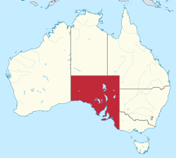
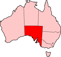
جنوب أستراليا أو أستراليا الجنوبية (بالإنجليزية: South Australia) هي إحدى ولايات أستراليا، تقع في الجزء الجنوبي من البلاد. تغطي المراعي الجافة جزء كبيراً من الأراضي في غرب المرتفعات الشرقية. في تلك المنطقة ترعى قطعان الضأن. الولاية جزء من أراضي الهضبة الغربية. الولاية تحتل المرتبة الرابعة بالنسبة لولايات أستراليا من حيث المساحة، وتقع على الساحل الجنوبي. تغطي مساحتها ثمن القارة الأسترالية تقريباً. طول ساحلها يصل إلى أكثر من 3500 كيلومتراً. مساحتها 1043514 كم2.
| أستراليا الجنوبية | |||||
|---|---|---|---|---|---|
| |||||
| Slogan or nickname | The Festival State; The Wine State | ||||
 Other Australian states and territories | |||||
| Coordinates | 30°S 135°E / 30°S 135°ECoordinates: 30°S 135°E / 30°S 135°E | ||||
| Capital city | أدليد | ||||
| Demonym | South Australian, Croweater (colloquial),[1] South Aussie | ||||
| Government | Constitutional monarchy | ||||
| - Governor | Hieu Van Le | ||||
| - Premier | Jay Weatherill (ALP) | ||||
| Australian state | |||||
| - Declared as Colony | 1834 | ||||
| - Proclaimed | 28 December 1836 | ||||
| - Responsible government | 22 أبريل 1857 | ||||
| - أصبحت ولاية | 1901 | ||||
| - Australia Act | 3 March 1986 | ||||
| Area | |||||
| - Total | 1٬043٬514 كم² (4th) 402٬903 sq mi | ||||
| - Land | 983٬482 كم² 379٬725 sq mi | ||||
| - المياه | 60٬032 طك² (5.75%) 23٬178 sq mi | ||||
| السكان (End of March 2014)[2] | |||||
| - السكان | 1,682,600 (5th) | ||||
| - Density | 1.67/km² (6th) 4٫3 /sq mi | ||||
| Elevation | |||||
| - Highest point | Mount Woodroffe 1,435 m (4,708 ft) | ||||
| - Lowest point | Kati Thanda-Lake Eyre −16 m (−52 ft) | ||||
| Gross state product (2010–11) | |||||
| - Product ($m) | $86٬323[3] (5th) | ||||
| - ن.م.إ. للفرد | $52٬318 (7th) | ||||
| منطقة التوقيت | UTC+9:30 (ACST) UTC+10:30 (ACDT) | ||||
| التمثيل الفدرالي | |||||
| - مقاعد مجلس النواب | 11/150 | ||||
| - مقاعد مجلس الشيوخ | 12/76 | ||||
| Abbreviations | |||||
| - الرمز البريدي | SA | ||||
| - ISO 3166-2 | AU-SA | ||||
| Emblems | |||||
| - الزهرة | Sturt's Desert Pea (Swainsona formosa) | ||||
| - الحيوان | Southern hairy-nosed wombat (Lasiorhinus latifrons) | ||||
| - الطائر | Piping shrike | ||||
| - السمكة | Leafy seadragon (Phycodurus eques) | ||||
| - المعدن أو الحجر | Opal | ||||
| - Colours | Red, blue, and gold | ||||
| الموقع الإلكتروني | www | ||||
تعد الولاية الأكثر جفافاً في أستراليا. في 80 % من مساحتها الإجمالية يهطل مقدار من المطر أقل من 254 مم سنوياً. رغم ذلك فإن الولاية تعرف بإنتاجها الوافر للقمح والشعير وغير ذلك. بسبب مهرجان أديليد ومهرجان قطف العنب في وادي باروسا، تعرف الولاية بأنها مقاطعة المهرجانات. تشتهر الولاية بوجود سلسلة جبلية تدعى لوفتي تجذب العديد من السياح. هذا بالإضافة إلى البحيرات البركانية في مونت جامبير، وغابة الصنوبر الملكية في جنوب شرق الولاية، والمغارات الجيرية في ناراكورت.
عاصمتها أديليد، ومن أكبر مدنها الأخرى: وايالا، وماونت جامبير، وبورت أوغستا، وبورت بري، وبورت لنكولن. عدد سكانها 1540200 نسمة، يعيش 75 % منهم في العاصمة أديليد. يوجد فيها إنتاج زراعي، كما يوجد فيها عدة صناعات مثل: الأجهزة، والمواد الكيميائية، والمنتجات الكهربائية والحديد والصلب، والآلات، والسيارات والسفن. يوجد فيها جامعتين هما جامعة أديليد وجامعة فلندرز.
. . . . . . . . . . . . . . . . . . . . . . . . . . . . . . . . . . . . . . . . . . . . . . . . . . . . . . . . . . . . . . . . . . . . . . . . . . . . . . . . . . . . . . . . . . . . . . . . . . . . . . . . . . . . . . . . . . . . . . . . . . . . . . . . . . . . . . . . . . . . . . . . . . . . . . . . . . . . . . . . . . . . . . . .
التاريخ
الجغرافيا
| بيانات مناخ أستراليا الجنوبية | |||||||||||||
|---|---|---|---|---|---|---|---|---|---|---|---|---|---|
| الشهر | يناير | فبراير | مارس | أبريل | مايو | يونيو | يوليو | أغسطس | سبتمبر | اكتوبر | نوفمبر | ديسمبر | العام |
| العظمى القياسية °س (°ف) | 50.7 (123.3) |
48.2 (118.8) |
46.5 (115.7) |
42.1 (107.8) |
36.5 (97.7) |
34.0 (93.2) |
34.2 (93.6) |
36.5 (97.7) |
41.5 (106.7) |
45.4 (113.7) |
47.9 (118.2) |
49.1 (120.4) |
50٫7 (123٫3) |
| الصغرى القياسية °س (°ف) | 0.2 (32.4) |
0.8 (33.4) |
-2.2 (28) |
-3.5 (25.7) |
-6.6 (20.1) |
-8.1 (17.4) |
-8.2 (17.2) |
-6.0 (21.2) |
-4.5 (23.9) |
-4.4 (24.1) |
-2.0 (28.4) |
-0.5 (31.1) |
−8٫2 (17٫2) |
| Source: Bureau of Meteorology[4] | |||||||||||||
الاقتصاد
الحكم
| Composition of the Parliament of South Australia | ||
|---|---|---|
| Political Party |
House of Assembly |
Legislative Council |
| Labor | 23 | 7 |
| Liberal | 22 | 8 |
| Family First | 0 | 2 |
| Nick Xenophon Group | 0 | 2 |
| Greens SA | 0 | 2 |
| D4D | 0 | 1 |
| Independent | 2 | 1 |
| Source: Electoral Commission SA | ||
الديمغرافيا
الأماكن
انظر ايضاً
- أستراليا
- Outline of Australia
- Index of Australia-related articles
- قالب:Wikipedia books link
- أدليد
- Country Fire Service
- Proclamation Day: 28 December 1836
- South Australian Ambulance Service
- South Australian English
الطعام والشراب
قوائم
مراجع
- Dorothy Jauncey, Bardi Grubs and Frog Cakes – South Australian Words, Oxford University Press (2004) ISBN 0-19-551770-9
. . . . . . . . . . . . . . . . . . . . . . . . . . . . . . . . . . . . . . . . . . . . . . . . . . . . . . . . . . . . . . . . . . . . . . . . . . . . . . . . . . . . . . . . . . . . . . . . . . . . . . . . . . . . . . . . . . . . . . . . . . . . . . . . . . . . . . . . . . . . . . . . . . . . . . . . . . . . . . . . . . . . . . . .
الهامش
- ^ "Wordwatch: Croweater". ABC NewsRadio. Archived from the original on 2005-09-15. Retrieved 11 October 2011.
- ^ "3101.0 – Australian Demographic Statistics, Mar 2012". Australian Bureau of Statistics. 27 September 2012. Retrieved 5 October 2012.
- ^ 5220.0 – Australian National Accounts: State Accounts, 2010–11.
- ^ "Official records for Australia in January". Daily Extremes. Bureau of Meteorology. 31 July 2013. Retrieved 12 March 2014.
- ^ 1345.4 – SA Stats, Jun 2011
وصلات خارجية
- الموقع الرسمي
- sa.gov.au
- Official Insignia and Emblems Page
- University of South Australia
- South Australian Tourism Commission – Travel Guides, Accommodation, Tours, Online Booking, Maps etc
- South Australia's greenhouse (climate change) strategy (2007-2020)
- Ground Truth – towards an Environmental History of South Australia Community resources


