الخضيرة
الخضيرة أو (بالعبرية: חֲדֵרָה, Ḥadera حديرا) هي مدينة تقع في منطقة حيفا في إسرائيل تقريباً في منتصف الطريق بين تل أبيب وحيفا. أوجدت المدينة على شكل قرية أقامها يهود مهاجرون من أوروبا الشرقية من جماعة حوفيفي صهيون عام 1891 بعد أن اشترى الأرض الناشط اليهودي يهوشع حنكين من أفندي مسيحي يدعى سليم خوري حيث كانت الأرض المحيطة بالقرية مستنقعات في حين أن سكانها كانوا من البدو والرعاة العرب الذين يقوا يرعون مواشيهم في أرض القرية في حين تخللت علاقتهم مع اليهود فترات غير مستقرة. يقع في قلب المدينة كنيس يهودي وإلى جانبه بقايا خان عربي قديم الذي استخدم كسكن أولي للمستوطنين الأوائل في القرية.
الخضيرة
| |
|---|---|
 | |
 | |
 الخضيرة  الخضيرة | |
| الإحداثيات: 32°27′N 34°55′E / 32.450°N 34.917°ECoordinates: 32°27′N 34°55′E / 32.450°N 34.917°E | |
| البلد | |
| المنطقة | حيفا |
| تأسست | 1891 |
| الحكومة | |
| • النوع | مدينة (من 1952) |
| • العمدة | Zvika Gendelman |
| المساحة | |
| • الإجمالي | 53 كم² (20 ميل²) |
| التعداد (2019)[1] | |
| • الإجمالي | 97٬335 |
| معنى الاسم | الخضراء(بالعربية) |
| الموقع الإلكتروني | https://www.hadera.muni.il/ |

. . . . . . . . . . . . . . . . . . . . . . . . . . . . . . . . . . . . . . . . . . . . . . . . . . . . . . . . . . . . . . . . . . . . . . . . . . . . . . . . . . . . . . . . . . . . . . . . . . . . . . . . . . . . . . . . . . . . . . . . . . . . . . . . . . . . . . . . . . . . . . . . . . . . . . . . . . . . . . . . . . . . . . . .
التاريخ
العصر العثماني


تأسست الخضيرة في 24 يناير 1891، في الأيام المبكرة للصهيونية على يد مهاجرين يهود من لتوانيا ولاتڤيا على أرض اشتراها يهوشع هانكن، المعروف بلقب "مخلّص الوادي".[2] وقد اشترى الأرض من افندي مسيحي، سليم خوري. وكانت تلك أكبر صفقة شراء أراضي في أرض إسرائيل من قِبل جماعة صهيونية، بالرغم من أن الأرض كانت ذات جودة منخفضة وتملؤها المستنقعات. السكان الوحيدون قبل الشراء كانوا بضعة عائلات ترعى الجاموس وتبيع خوص البردي.[3] سُميت القرية على اسم وادي الخضيرة[4] (العربية: وادي الخضيرة),[5] كما كان يُعرف الجزء القريب من غدير الخضيرة. وقبل ذلك، فإن كل غدير الخضيرة كان يُعرف بإسم نهر الأخضر.[6][7]
سمّى الصليبيون الموقع Lictera – وهو تحوير للاسم العربي، الخضيرة. مذن البداية، جرت محاولات لإطلاق اسم عبري على المستوطنة الجديدة.[8] وبعد نحو نصف عام من تأسيسها، أفاد الحاخام يعقوڤ گولدمان حول حدث في "موشاڤ هاديره Hadere، أي هاتسور".[9] الاسم ليكتيرا كان الاستخدام المفضل من قِبل العسكريين البريطانيين أثناء الحرب العالمية الأولى.[10][11]
زعم المساح الخاص للبارون إدموند جيمس دى روتشيلد، يتسحاق گولدهار، أن هاديرا كانت مبنية على موقع بلدة سابقة تُدعى گـِديرا قيصارية (بالعبرية: גדרה של קיסרין)، كما ذُكِر في توسفتا شڤعيت، الفصل 7.[12] فضـّل بنجامن مزار أن گادور القديمة، المعروفة سابقاً بإسم گـِديرا بجانب قيصارية، في تل الاخضر، ولاحقاً عُرفت بإسم تل الشيخ زيرق[13] and currently as Tel Gador، على الساحل جنوب گڤعات أولگا.[14] ويقول آخرون أن گـَديرا القديمة يجب تـُقرَن مع أم قيس أو مع الجديرة.
عاش المستوطنون اليهود الأوائل في مبنى عُرف بإسم "الخان" بالقرب من الكنيس الرئيسي بالخضيرة.[بحاجة لمصدر] تكون المجتمع من عشر عائلات وأربع حراس. في 1896 دفع البارون روتشيلد لـ "مئات العمال السود" من مصر "ليحفروا خنادق عريضة وعميقة" لتجفيف المستنقعات. They "died in scores".[15][16] شواهد القبور القديمة في المقبرة تكشف أنه من تعداد 540 نسمة، فقد مات 210 بالملاريا.[17] ولذلك، نُقِش إصحاح من مزامير التوراة (تهليم) في شعار المدينة: "أولئك الذين بذروا الدموع، سوف يحصدون بأغاني الفرح." (المزمور 126:5). وواصل حراس هاشومر مراقبة الحقول لمنع هجمات البدو المجاورين.
وبحلول مطلع القرن العشرين، أصبحت الخضيرة المركز الاقتصادي الإقليمي.[2] وفي 1913، ضمت المستوطنة أربعين عائلة، وكذلك حقول وكروم، تمتد على 30,000 دونم.[12]
الانتداب البريطاني
في تعداد فلسطين 1922 الذي أجـْرَته سلطات الانتداب البريطاني، بلغ إجمالي تعداد الخضيرة 540 نسمة؛ 89 مسلم، 1 مسيحي و 450 يهودي.[18] نزاعات الأراضي في المنطقة تم حلها بحلول عقد 1930، ونما التعداد إلى 2,002 نسمة في 1931.[بحاجة لمصدر] أُدخِل التعليم المجاني في المدينة في 1937 في كل المدارس عدا مدرسة الهستدروت.[19]

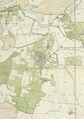
الخضيرة 1932 1:20,000
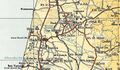
الخضيرة 1945 1:250,000


دولة إسرائيل
بعد حرب 1948، توسع الجزء الشمالي الغربي من الخضيرة (بما في ذلك "نڤى حاييم") على الأراضي التي كانت مِلك قرية عرب الفقراء الفلسطينية المُفرَغة بقوة السلاح.[20]
Hadera's population increased dramatically in 1948 as immigrants flocked to the country. Most of the newcomers were from Europe, though 40 Yemenite families settled there, too.[17] In 1953, Israel's first paper mill opened in Hadera. Financed by investors from Israel, United States, Brazil and Australia, the mill was designed to meet all of Israel's paper needs.[21] New neighborhoods were built, among them Givat Olga on the coast, and Beit Eliezer in the east of the city. In 1964, Hadera was declared a city.[2]
In the 1990s, large numbers of Russian and Ethiopian immigrants settled in Hadera.[2] Hadera, considered a safe place by its inhabitants, was jolted by several acts of terrorism during the second intifada. On October 28, 2001, four civilians were killed when a terrorist opened fire on pedestrians at a bus stop.[22] A massacre of six civilians at a Bat Mitzvah occurred in early 2002.[23] A suicide bomber blew himself up at a falafel stand on October 26, 2005, killing seven civilians[24][25] and injuring 55, five in severe condition.[26] During the second Lebanon War, on August 4, 2006, three rockets fired by Hezbollah hit Hadera. Hadera is 50 miles (80 km) south of the Lebanese border and marked the farthest point inside Israel hit by Hezbollah.[27]
In the 2000s, the city center was rejuvenated, a high-tech business park was constructed, and the world's largest desalination plant was built.[2][28] New neighborhoods are under construction in the underdeveloped northeastern part of the city, and plans are under way for a large park, shopping malls and hotels with a total of 1,800 rooms.

The city is envisaged as a future vacation destination due to its closeness to the Galilee, beaches, and access to major highways.[29]
ديمغرافيا
According to the Israel Central Bureau of Statistics, as of October 2013, Hadera had a population of 91,634 which is growing at an annual rate of 1.2%.[30] As of 2003, the city had a population density of 1,516.6 per km2.[31] Of the city's population of 2013 of 91,634, approximately 23,407 were immigrants, many from Ethiopia.[31]
According to a census conducted in 1922 by the British Mandate authorities, Hadera had a population of 540 inhabitants, consisting of 450 Jews, 89 Muslims and 1 Christian.[32] Hadera has grown steadily since 1948, when the city had a population of 11,800. In 1955, the population almost doubled to 22,500. In 1961 it rose to 25,600, 1972 to 32,200, and 1983, to 38,700.[31]
In 2003, the ethnic makeup was 93.2% Jewish, 0.8% Arab and 6.0% other.[33] In 2000, there were 27,920 salaried workers and 1,819 self-employed. The mean monthly wage in 2000 for a salaried worker was ILS 5,135, a real change of 8.0% over the course of 2000. Salaried males had a mean monthly wage of ILS 6,607 (a real change of 9.0%) compared with ILS 3,598 for females (a real change of 3.1%). The mean income for the self-employed was 6,584. A total of 1,752 people received unemployment benefits and 6,753 received income supplements. In 2019, the total population was 97,334, of which 91.8% were Jewish and 0.9% were Arab.[33]
الاقتصاد

Hadera Paper, established in 1953, continues to be a major employer in the city. The world's largest desalination plant of its type,[34] was inaugurated in December 2009.[2] Hadera is the location of the Orot Rabin Power Plant, Israel's largest power station.[35]
المدن الشقيقة
 بزانسون، فرنسا
 بيگ سپرنگ، الولايات المتحدة
- شارلوت، الولايات المتحدة (2008)
 دربند، داغستان، روسيا الاتحادية
- إل پاسو، الولايات المتحدة (2015)[37]
 نورنبرگ منذ عام 1995.
 ريژاو، الصين
 تومار، البرتغال[38]
- سانت پول، مينسوتا، الولايات المتحدة (منذ عام 1981)
 هارن (خروننگن) في هولندا.
- جاكسونڤل، فلوريدا، الولايات المتحدة
. . . . . . . . . . . . . . . . . . . . . . . . . . . . . . . . . . . . . . . . . . . . . . . . . . . . . . . . . . . . . . . . . . . . . . . . . . . . . . . . . . . . . . . . . . . . . . . . . . . . . . . . . . . . . . . . . . . . . . . . . . . . . . . . . . . . . . . . . . . . . . . . . . . . . . . . . . . . . . . . . . . . . . . .
الهامش
- ^ "Population in the Localities 2019" (XLS). Israel Central Bureau of Statistics. Retrieved 16 August 2020.
- ^ أ ب ت ث ج ح "New Urbanism, Israeli Style". Haaretz. Retrieved 2008-11-28.
- ^ Avneri, Aryeh L. (1984). The Claim of Dispossession: Jewish Land-Settlement and the Arabs, 1878-1948. Transaction Publishers. p. 93. ISBN 0-87855-964-7. Retrieved 2008-10-25.
- ^ Yehoshua Levinzon (1959). HaSharon (PDF). Tel Aviv: Ma'arachot.
חדרה נקראה על שם הנחל הסמוך, אשר קטע ממנו נקרא בערבית ואדי חודֵירה - הנחל הירקרק.
- ^ The Survey of Western Palestine: A General Index. Vol. 1. London: Committee of the Palestine Exploration Fund. 1838. p. 155.
- ^ Trelawney Saunders (1881). An Introduction to the Survey of Western Palestine: its Waterways, Plains, & Highlands. London: Richard Bentley and Son. pp. 24, 32–33.
- ^ Marom, Roy (2021-06-09). "The Abu Hameds of Mulabbis: an oral history of a Palestinian village depopulated in the Late Ottoman period". British Journal of Middle Eastern Studies: 2. doi:10.1080/13530194.2021.1934817. ISSN 1353-0194. S2CID 236222143.
- ^ Irit Zaharoni (1990). Israel, Roots & Routes: A Nation Living in Its Landscape. Ministry of Defense (Israel). p. 288.
- ^ Ya'akov Goldman (1891) [Tammuz 5651 (July-Aug)]. "שאר ישוב". In Ze'ev Yavetz (ed.). מירושלם [Mirushalayim]. Vol. 1. Warsaw: Schuldberg Brothers. p. 13).
לנחלת חדֶרי (היא חצור) כבר נעשתה "מֻצְדַקְיָה"
- ^ Through Palestine with the 20th Machine Gun Squadron. London. 1920. p. 113.
the Brigade, winding its way through the groves, came out into the pretty little Village of Liktera (a Jewish settlement called by them Hudeira)
{{cite book}}: CS1 maint: location missing publisher (link) - ^ John D. Grainger (2013). The Battle for Syria, 1918-1920. Boydell Press. p. 133. ISBN 9781843838036.
At Liktera (also called Hadera) on the Nahr el-Mafjir, another five miles on, the division halted
- ^ أ ب Yitzhak Goldhar (1913). "4. הימים שמקיפין את ארץ ישראל.". אדמת קדש [Admat Kodesh]. Frankfurt am Main: Jiddisch Literarische Gesellschaft. pp. 83–84.
כמעט באמצע המרחק שבין עין טב ולבין קיסרין במרחק 2½ קילומיטר למערבה של החורבה הנקראת תל דרור היא עיר דאר שבחלק מנשה (ב) נוסדה (בשנת התרנ"א) מושבה של יהודים שקראו לה חֶידֶירֶה ואולם גדרה שמה לראשונה כי המושבה הזאת נבנתה במקום אשר לפנים היתה עיר גדרה של קיסרין הנזכרת בתוספתא שביעית פ"ז: ושאר כל ארצות אוכלין עד שיכלו מבית אל ומגדרה של קיסרין. [...] בגדרה של קיסרין יושבים כעת ארבעים בעלי בתים ולהם שדות וכרמים ובתים טובים. כל שטח אדמתם עולה בערך שלשים אלף דולאם.
- ^ Archaeological Survey of Israel
- ^ B. Maisler (1934). "Der Distrikt Śrq in den Samarischen Ostraka". The Journal of the Palestine Oriental Society: 96–100.
Für (A)gdōr = Gedera kommt m.E. kein anderer Punkt so sehr in Betracht, als Tell Ahḍar an der Meeresküste, kaum 7 km. südlich von Caesarea. Tell Ahḍar ist eine ausgedehnte Ruinenstätte, die zahlreiche antike Säulen und sonstige Reste aus römischer Zeit aufweist.
- ^ Gilbert, Martin (1998). Israel, a History. Morrow. p. 9. ISBN 0-688-12362-7.
- ^ Barbour, Nevill Nisi Dominus - A Survey of the Palestine Controversy. First published 1946. The Institute for Palestine Studies, Beirut 1969. Reprint series No. 3. p.115
- ^ أ ب Winter, Dave (1999). Israel Handbook. Footprint Travel Guides. p. 532. ISBN 1-900949-48-2. Retrieved 2008-10-25.
- ^ Barron, J.B., ed. (1923). Palestine: Report and General Abstracts of the Census of 1922. Government of Palestine. p. 33.
- ^ Sternhell, Zeev (1999). The Founding Myths of Israel: Nationalism, Socialism, and the Making of the Jewish State. Princeton University Press. p. 255. ISBN 0-691-00967-8. Retrieved 2008-10-25.
- ^ Khalidi, W. (1992). All That Remains: The Palestinian Villages Occupied and Depopulated by Israel in 1948. Washington D.C.: Institute for Palestine Studies. p. 144. ISBN 0-88728-224-5.
- ^ "First Paper Mill Opened in Israel; Plant at Hadera is Expected to Help Nation Cut Currency Gap $1,000,000 a Year". New York Times. 1953-12-18. Retrieved 2008-10-25.
- ^ Victims of Palestinian Violence and Terrorism since September 2000
- ^ "Bat mitzvah massacre in Israel leaves seven dead". The Independent (in الإنجليزية). 2002-01-18. Retrieved 2020-06-07.
- ^ "Larissa Grishchenko". GxMSDev.
- ^ Ben-Zur, Raanan (17 September 2009). "Woman injured in Hadera terror attack dies 4 years later". ynet.
- ^ "Suicide bomber rocks Hadera market". Haaretz.com. 27 October 2005.
- ^ "For first time: Hizbullah targets Hadera area". Ynet News. 2006-08-04. Retrieved 2008-11-30.
- ^ Rabinovitch, Ari (16 May 2010). "Israel opens largest desalination plant of its kind". Reuters. Retrieved 2013-03-26.
- ^ "No Longer a Backwater, Hadera Plans Big Push - Inside Israel". Israel National News.
- ^ "Table 3 - Population of Localities Numbering Above 2,000 Residents" (PDF). Israel Central Bureau of Statistics. 2010-06-30. Retrieved 2010-10-30.
- ^ أ ب ت "Population and Density per Km² in Localities Numbering Above 5,000 Residents" (PDF). 55th Statistical Yearbook. Israel Central Bureau of Statistics. 2003. Archived from the original (PDF) on 2008-02-29. Retrieved 2008-03-15.
- ^ "Palestine Census ( 1922)" – via Internet Archive.
- ^ أ ب Central Bureau of Statistics, [1]
- ^ Rinat, Zafrir (2008-04-02). "Where will the water go? - Haaretz Daily Newspaper | Israel News". Haaretz.com. Retrieved 2011-09-16.
- ^ Paz, Shelly (2007-03-01). "Greenpeace protests at Hadera power plant | Israel | Jerusalem Post". Jpost.com. Retrieved 2009-05-05.
- ^ "Hadera - Identity Card". forum15.org.il. Forum 15. Retrieved 2020-02-25.
- ^ "New Sister City Relationship". embassies.gov.il. Consulate General of Israel in Houston. 2015-05-20. Retrieved 2020-02-25.
- ^ "Cidade vai ter geminação com Ribeira Grande de Santiago (Cabo Verde)". mediotejo.net (in البرتغالية). Mediotejo. 2019-09-18. Retrieved 2020-02-25.
وصلات خارجية
- Official website {{{1}}}, {{{2}}}